Articles tagged with: PETER MUMFORD

In a modern mobile mapping system, the navigation component usually consists of a GPS receiver and an inertial navigation system (INS), which can provide accurate geo-referencing to the imaging sensors [1][2]. To achieve centimetre-level positioning accuracy, RTK-GPS is a natural choice. However, RTK-GPS in urban areas suffers from frequent outages due to blockages of either the GPS signals or the reference station radio links. In addition, multipath from buildings, trees and heavy vehicles could degrade the accuracy of the GPS when the vehicle is near them.

Although Global Navigation Satellite Systems (GNSS) technology is developing rapidly, the major disadvantage of GNSS will still exist even when the European Galileo system is fully operational, that is, signal blockage due to obstructions and the low power of the signals. The combination of GNSS with a self-contained inertial navigation system (INS) provides an ideal solution, which can not only address the weakness of GNSS and but also bound…

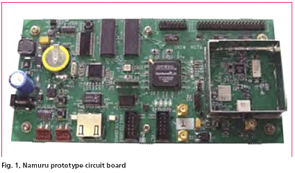
Development of a Field Programmable Gate Array (FPGA) based GNSS receiver platform has been underway at the University of New South Wales (UNSW) ‘SNAP’ lab since 2004. The receiver now has a name; ‘Namuru’ that means ‘to see the way’ in the language of the Eora people who inhabited an area around Sydney, including the UNSW campus, before the arrival of the British. The receiver was introduced in the Coordinates January 2006 edition and in this article we first provide a brief recap and then look at the latest developments and results from testing. But before launching into this, the question of why such a research and development platform is desirable must be answered.

In early 2004 a plan was hatched to develop a Global Navigation Satellite System (GNSS) receiver based around Field Programmable Gate Array (FPGA) technology as a platform to support research in this fi eld. A joint project was set up between the School of Surveying and Spatial Information Systems (SISS) at the University of New South Wales and the National ICT Australia (NICTA), and soon after a small team was established. The team consisted of Kevin Parkinson, a post-graduate student at SISS with experience in FPGA and circuit board design, Frank Engel, a researcher with NICTA with software, Real Time Operating Systems (RTOS) and VHDL design knowledge and me, Peter Mumford from the SISS GNSS research group. At the end of the project we hoped to have an L1 GPS receiver running on a custom circuit board with the baseband processor and navigation solution processor running on an FPGA chip. The project is coming to an end now, and in this article, I will describe our design path, what has been achieved to date and then some potential research areas, but fi rst a little background.


 (5.00 out of 5)