
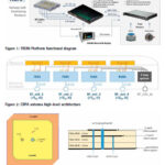
This paper presents the TRENI railway GNSS receiver and antenna development, to be used directly or integrated in a train multi-sensor safe positioning platform, suitable for railway safety-related applications
Marco Puccitelli
Thales Alenia Space Italia., Via E. Mattei 1, 20064 Gorgonzola (Milan), Italy
Chiara Manno
Thales Alenia Space Italia., Via E. Mattei 1, 20064 Gorgonzola (Milan), Italy
Livio Marradi
Thales Alenia …

This paper offers a state-of-the-art review of several proposed methods for interference detection and mitigation with solutions ranging from traditional to machine learning-based approaches.
Arul Elango
Department of Computer Science, University of Helsinki, Finland
Ahmed Al-Tahmeesschi
Department of Computer Science, University of Helsinki, Finland
Mikko Saukkoriipi
Department of Computer Science, University of Helsinki, Finland
Titti Malmivirta
Department of Computer Science, University of Helsinki, …

A clear, methodical and scientific distinction needs to be drawn between land use and land cover, especially in the context of urban planning and development
Dr Mahavir
Former Professor and Dean (Academic), School of Planning and Architecture, New Delhi, India
Dr Prabh Bedi
CEO, Resonance Integrated Solutions Canada Inc., Canada
The geospatial industry got another impetus from Government of India …
The University of New South Wales has produced an advanced satellite receiver that accepts GPS and Galileo signals. This locally developed technology could play an important role in Australia’s space future.
This receiver accepts signals from two satellite systems, GPS and Galileo, across multiple frequencies. The Australian Space Agency provided funding via the International Space Investment …
After years of negotiations, the member states of the United Nations have finally reached an agreement on the conservation of biodiversity in the oceans. The High Seas Treaty must protect international waters, which make up about two thirds of the ocean surface.
Two thirds of the oceans lie outside countries’ exclusive economic zones and belong to …
CHC Navigation has released the NX510 SE Auto-Steer, an automated steering system that retrofits several types of new and old farm tractors and other vehicles. It can be connected to local real-time kinematic (RTK) networks or GNSS RTK base stations.
NX510 SE is a guidance controller powered by multiple corrections sources and five satellite constellations: GPS, …
North America’s geospatial science data firm, NV5 Geospatial, announced that it will conduct aerial lidar and orthoimagery surveys across the Caribbean on behalf of the Caribbean Community Climate Change Centre (CCCCC).
Funded by the Caribbean Development Bank (CDB), this pilot project will provide advanced geospatial data to help the island nations better understand natural and man-induced …
Rohde & Schwarz will launch its R&S EVSD1000 VHF/UHF nav/drone analyzer. The analyzer provides accurate and efficient drone inspection of terrestrial navigation and communications systems along with outstanding accuracy and the measurement repeatability customers need.
The R&S EVSD1000 VHF/UHF nav/drone analyzer is a signal level and modulation analyzer for medium-sized drones. It is the only instrument …
Orbital Insight, specialising in Geospatial intelligence, and Carahsoft Technology Corp., announced a partnership. Under the agreement, Carahsoft will serve as Orbital Insight’s Master Government Aggregator.
This makes the company’s AI-powered geospatial data analytics available to the Public Sector through Carahsoft’s reseller partners, and Information Technology Enterprise Solutions – Software 2 (ITES-SW2), NASA Solutions for Enterprise-Wide Procurement …


 (5.00 out of 5)