

The findings of this study show the potential of using UAS-lidar as a sampling tool for estimating and monitoring AGB and other forest structural attributes.
Hastings Shamaoma
Department of Urban and Regional Planning, Copperbelt University, 21692 Kitwe, Zambia.
Paxie W. Chirwa
Forest Science Postgraduate Programme, Department of Plant and Soil Sciences, University of Pretoria, Private Bag X20, Hatfield, Pretoria …

We present a detailed landslide vulnerability map developed on the Google Earth Engine (GEE) platform using a Weighted Overlay Model.
Dr. Satish Kumar Negi
Associate Professor, Department of Geography, Govt. Degree College Dharampur, Solan, Himachal Pradesh, India
Shashi Shekha
Scientific Officer, H.P. State Pollution Control Board, Shimla, Himachal Pradesh, India
Abstract
This study addresses the escalating threat of landslides in Himachal …
The General Authority for Survey and Geospatial Information (GEOSA) and the Singapore Land Authority (SLA) officially launched the outcomes of their cooperation project to develop and manage the geospatial system. The partnership is part of GEOSA’s broader effort to establish a robust national geospatial infrastructure, aligning with global best practices to enhance the positive and …
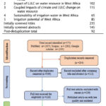
This study aims to review the existing literature on the impacts of climate, and LULC changes on the sustainability of irrigation water in West Africa.
Gemechu Fufa Arfasa
Department of Natural Resource Management, Wolaita Sodo University, Sodo, Ethiopia
Ebenezer Owusu-Sekyere
Faculty of Natural Resources and Environment, Department of Environment and Sustainability Sciences, University for Development Studies, Tamale, Ghana
Dzigbodi Adzo …

In this study, a small-scale customised drone – the so- called Maggy – was developed to simplify and automate the procedures of cleaning explosive devices. Readers may recall that we publsihed the first part of the paper in February issue. We present here the concluding part
Kaya Kuru
School of Engineering and Computing, University of Central Lancashire, …
On 13 March 2025, the High Court of Malaya granted leave for the judicial review concerning the amendments to the Licensed Land Surveyors (Amendment) Act 2024 and the Licensed Land Surveyors (Amendment) Regulations 2024.
The High Court also issued an ad interim stay, which applies exclusively to the Institution of Geospatial and Remote Sensing Malaysia (IGRSM) …

In this study, a small-scale customised drone – the so- called Maggy – was developed to simplify and automate the procedures of cleaning explosive devices. We present here the first part of the paper. The conculding part of the paper will be publsihed in March issue.
Kaya Kuru
School of Engineering and Computing, University of Central Lancashire, …
e-GEOS (Telespazio 80% and ASI 20%) is Prime Contractor of the consortium commissioned by the European Space Agency (ESA) to develop a digital twin for the simulation of heat island and urban flooding scenarios. The project, called “SURE” (Smart Urban Resilience Enhancement), began on 6 November.
The project will be developed by a consortium led by e-GEOS …
A total of 13 professional organisations, representing a broad range of professions, have joined in issuing the attached press release, formally protesting the legislative amendment and advocating for more inclusive regulations in Malaysia.
They highlight their joint concerns regarding the amendment to the Licensed Land Surveyors Act 1958 and accompanying regulations (Licensed Land Surveyors (Amendment) Regulations …
Following the Town Hall session held on 9 September 2024 by the Ministry of Natural Resources and Environmental Sustainability, Land Surveyors Board (LJT) and Department of Survey and Mapping Malaysia (JUPEM), we are compelled to express our deep concerns regarding the amendment to the Licensed Land Surveyors Act 1958 (Akta Jurukur Tanah Berlesen 1958) and …


 (5.00 out of 5)