| My News | |
Resilient PNT – Making way through rough waters
The Accessibility for Shipping, Efficiency Advantages and Sustainability (ACCSEAS) project will be considering several means of obtaining alternative PNT information |
 |
|
 |
|
 |
|
The International Maritime Organisation (IMO) is developing e-Navigation as the future approach to marine navigation in order to enhance maritime safety. As such, the IMO state that positioning systems for e-Navigation “should be resilient …. robust, reliable and dependable. Requirements for redundancy, particularly in relation to position fixing systems should be considered” [1].
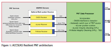
GPS has become the primary source of positioning for mariners; but no Global Navigation Satellite System (GNSS) alone can provide resilient Position, Navigation and Timing (PNT). GNSS, including GPS, GLONASS, BeiDou, QZSS and Galileo, is vulnerable to deliberate, accidental or natural radio interference. Despite these weaknesses, GPS has become a crucial element not only of maritime navigation, but also of critical national infrastructure, and is often used without any backup being provided. A complementary system, compatible with GNSS but independent from it, is essential to achieving the resilient PNT required for e-Navigation; it is also essential for supporting a wide range of national and international critical infrastructure systems. The Accessibility for Shipping, Efficiency Advantages and Sustainability (ACCSEAS) project will consider resilient PNT as part of its overall aim of developing potential e-Navigation services that will enhance maritime safety and efficiency within the North Sea Region (NSR). The project will develop an e-Navigation test bed within the NSR which will be used to demonstrate the potential e-Navigation services, developed by the project. The project is being completed by a collaboration of 11 partners from across the NSR, made up of service providers, industry and academia [2].
The need for resilient PNT
The ACCSEAS project is investigating the future navigation issues which are due to affect shipping in the NSR and has highlighted the fact that shipping density is set to increase with bigger, faster vessels, leading to reduced manoeuvrability. The navigable area of the North Sea will reduce in size due to the growth in offshore installations, such as wind farms and oil and gas platforms. As a result, the risk of an incident or accident occurring will increase, particularly at pinch points such as approaches to major ports and constrictions, such as Rotterdam and Dover, and inland waterways like the Kiel Canal.
Within this environment, the project recognizes that GPS has become the normal method used for maritime PNT, primarily because it is freely available and usually provides excellent performance. As a result, the number of GPS receivers installed on a ship’s bridge is increasing and, depending on the nature of the vessel operations, GPS data can be fed to a large number of the bridge systems, including some which may be unexpected, for example the vessel’s radar, gyrocompass and clocks.
In addition to ordinary positioning and navigation functionality, another key component affected is the Automatic Identification System (AIS). While AIS was developed to provide information fro


 (No Ratings Yet)


