| Geodesy | |
Mumbai floods: How GPS-GIS can help
|
||||||||||||
|
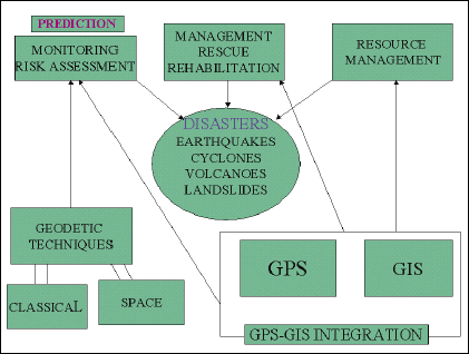
The 26th July 2005 floods in Mumbai, which caused widespread destruction, deaths and damage to property and infrastructure, have once again highlighted the importance of disaster mitigation and management using modern technology. Monitoring natural disasters like floods, earthquakes, volcanic eruptions, landslides, avalanches, cyclones, etc., with the ultimate aim of predicting them, and managing the rescue and rehabilitation operations during and after such calamities, have been discussed in various forums in the past. The devastating Latur earthquake of 1993, the Bhuj earthquake of 2001, the Orissa cyclone, and the recent tsunami after the Sumatra earthquake, which caused extensive damage in terms of human lives and property, have drawn the attention of the Indian scientific community to the immediate need of monitoring and managing such disasters in our country in the most effective, efficient and economic manner. Traditionally, maps are being used for this purpose, as an effective tool, since ancient times. However, with the introduction of computeraided techniques in map-making, and the space technology in surveying and mapping, the utility of geodetic and map data for this important activity has increased many-fold. However, a well-coordinated programme for optimum utilization of these important technological tools, resulting in efficient management of the disasters, still remains an elusive dream of administrators, scientists and technologists. The Geographical Information System (GIS), and the Global Positioning Both GPS and GIS have a vital role to play in the three aspects of disaster management: the rescue work, the relief work, and the rehabilitation work, including all types of rehabilitation: human, economic, dwellings, education, business, etc. Even though floods is a natural calamity, and no system can cope with a once-in-hundred years rainfall event, the importance of proper design and construction of the urban drainage system in managing floods in cities, is beyond question. Most recent and accurate maps/ GIS of the area, is a prerequisite for this. The Mumbai metropolitan region, with a total area of 4355 sq. km, consists of 1273 sq. km urban area, which has a population of 17.7 million, out of the total population of 18.9 million. Thus, this urban area has a very high population density of 139 persons per hector, as compared to overall density of only 43 persons per hector. Such high population density, in a gently undulating region, with several low elevation patches, requires a very elaborate drainage system. Such a system is certainly non-existent at present, which is the main cause of the severe flooding problems the city faces every year. Accurate large scale GIS of the entire region is a must for the planning, design and installation of such an elaborate drainage system. Considering the aspect of hazard assessment, an extensive GPS-based national programme for earthquake hazard assessment has been launched by the Department of Science & Technology (DST), since 1993. The extensive geodetic data being generated through the GPS networks established under this programme, can also contribute signifi cantly in monitoring the other natural disasters, like floods. These GPS stations can be utilized as base stations for precise positioning of rescue teams and vehicles during the disasters. Another important application is the use of GPS-GIS integrated systems to disaster mitigation and management. GPS, integrated with GIS, has the potential to become an effective tool for monitoring the natural disasters, and during the rescue and relief operations, for instantaneous accurate positioning, and as an input to the Digital maps and GIS. The integration of locationbased spatial mapping system: GIS, The effective monitoring and management of natural calamities requires the most recent terrain information, and quick updating of the digital maps / GIS of the affected area on real – time basis. For this purpose, aerial photographs and satellite imagery of the area, when integrated with the digital maps / GIS, can yield the best results. For controlling the scale and other errors in the imagery, ground survey control is absolutely essential. The GPS technique can be used for this purpose, to yield very accurate results in an efficient and economic way. The GPS receivers on-board the camera can provide the accurate co-ordinates in realtime basis, and GPS surveys on the ground can establish an accurate GPS ground control network. In conclusion, an integrated approach to include input from several diverse techniques is a must for understanding, monitoring and managing the various natural and man-made disasters. It is essential that coordination at all levels must be ensured to facilitate smooth functioning of the entire system, easy data exchange, and scientific cooperation. Frequent meetings of the agencies involved in the work, and close monitoring are essential for this purpose. It is important that latest digital map data on largest possible scale, and GPSGIS integrated positioning systems are made available to the disaster management teams, for effective rescue and rehabilitation operations. |
||||||||||||
|
||||||||||||
|


 (No Ratings Yet)


