| Positioning | |
Meeting the demands of real-time positioning
|
|
|||||||||||||||||||||
Lars Jamtnas and Bo Jonsson
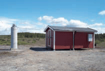
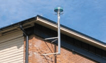
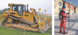
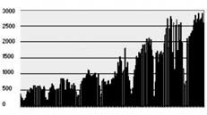
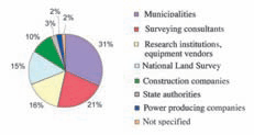
SWEPOS network RTK serviceThe SWEPOS Network RTK Service was launched in 2004, following the successful completion of several pre-study projects. The SWEPOS network has during recent years been extended step by step through establishment projects. The coverage area for the service approximately coincides Figure 2: One of the first SWEPOS stations, belonging to Class A. Figure 3: A SWEPOS station with a roof-mounted antenna, belonging to Class B. Figure 4: Two increasingly common production applications for SWEPOS positioning services are machine guidance and detail surveying (e.g. for mapping purposes) Figure 5: Total user connection time (in hours) per week for the SWEPOS Network RTK Service, from mid summer 2004 to late 2007. Figure 6: SWEPOS Network RTK Service users, per organization category (early April 2008). 33with the blue dotted area in figure 1. The SWEPOS Network RTK Service is based on the virtual reference station concept, with two-way communication between the RTK users and the SWEPOS Control Centre. GSM and GPRS (mobile Internet) are used as communication links, and users have the option to receive correction for either GPS or GPS/GLONASS. Given the average in-between station distances in the SWEPOS network of about 70km, the expected position accuracy is on the centimetre level. Data for the SWEPOS Network-RTK service is charged according to a subscription system based on unlimited or per-data access. Participants in the establishment projects have received a one-time discount if they have signed a subscription after the end of project. The number of registered users of the Network RTK service is now well over 1000, with the goal to have 1500 users within the next three years. The network RTK service is widely used for data capture in mapping applications, but also in several other areas such as cadastral surveying and for building and construction work (e.g. machine guidance). Figures 5 and 6 demonstrate some user statistics from the Network RTK Service. SWEPOS network DGNSS serviceSWEPOS single frequency Network DGNSS Service was launched in April 2006. This service runs on the same platform as the SWEPOS Network RTK Service. The expected position accuracy is at the decimetre level. The data for the SWEPOS DGNSS Service is charged according to a similar subscription system as the Network RTK Service. Figure 5: Total user connection time (in hours) per week for the SWEPOS Network RTK Service, from mid summer 2004 to late 2007.Figure 6: SWEPOS Network RTK Service users, per organization category (early April 2008). 34 | December 2008Typical applications are found within farming, forestry and GIS data capture. The Epos serviceThe Epos service is a DGPS service for metre accuracy, run by the Swedish company Teracom. The service is based on single-base DGPS corrections from a number of SWEPOS stations, distributed via FM radio. Epos was launched in 1994 when Selective Availability (SA) was activated in the GPS system. User experiencesDuring February 2008 a survey of the users of the SWEPOS Network-RTK service was carried out by questionnaire. We received close 400 answers from the 900 users. Most of the users were very satisfied with the performance of the service and considered it to be worth its price. The users were also very satisfied with the support from the personnel at the control centre. The survey indicated that almost 50 percent of the users can perform all their positioning with the Network RTK service. The present horizontal accuracy of the service meets the demands from most of the users, but a higher vertical accuracy than the present is required by 40% of the users. Better information about failures in the operation of SWEPOS through SMS messaging and the SWEPOS web site, and improved performance of the mobile Internet link (GPRS) were common proposals from the users. Other proposals concerned various improvements of user equipment, e.g. some standard for the internal position accuracy that is indicated in the GNSS rovers, and better initialization algorithms when you have many satellites available above the horizon. The users of the SWEPOS services expect high availability and high service performance. But this is a combination of the performance of the GNSS satellites, the GNSS rover equipment, the SWEPOS system and the cellular phone network. Because of the many links in the chain, it is at times hard to locate the reason behind a failed initialization of the user rover equipment. Notably, the coverage of the cellular phone network is still is a severe bottleneck in the rural parts of Sweden For the future the users expect that the SWEPOS Network RTK service is an improved tool in their toolbox which can be used in almost all their positioning needs because of increased number of signals and satellites, improved accuracy of the positions and improved coverage of mobile Internet. Of course the users also expect a reduction in the subscription fees for the services. One final note: many of the users of SWEPOS Network RTK service do not belong to the conventional surveying community. This has led to the development of a field manual for network RTK measurements with the SWEPOS service [3] which is distributed to all new users. The major Swedish GNSS equipment vendors also provide ready-to-go packages for the SWEPOS positioning services. These packages are tailor-made for different applications, and minimize the need for new users to master all aspects of their equipment in order to use the positioning services. Future plansThe remaining extension of the SWEPOS network will be carried out during 2009 (see figure 1). As with previous establishment projects, this will be a co-operative effort between a number of private and public participants, in order to create a viable user base for future contributions to operation and maintenance costs. A likely scenario in the near future will be an increasing demand for flexible solutions, primarily for real-time positioning in advanced applications (e.g. services fit for large-scale construction projects). Special attention will be paid to the use of the SWEPOS Network RTK Service for machine guidance and other forms of high-precision navigation. The infrastructure of SWEPOS will continue to be modernized, in order to benefit from further enhancements of present GNSS, such as the introduction of the new GPS L5- and GLONASS L3-frequencies, as well as the development of new satellite systems such as Galileo. Concluding remarksA multi-purpose network of permanent reference stations is beneficial for both users and providers of national geodetic infrastructure. It facilitates the development of services for positioning and non-safety-of-live navigation, and also the successful integration of GNSS technique into a wide range of applications. The professional use of these techniques is increasing very rapidly outside the conventional surveying community, which in turn spurs the development of more user friendly equipment and positioning concepts. The long-term plan for SWEPOS, which was developed in the early 1990s, will be completed in coming years. Further information about the SWEPOS network can be found at: www.swepos.com References[1] Jonsson B, Hedling G, Jämtnäs L, Wiklund P, 2006: SWEPOS Positioning Services – Status, Applications and Experiences. XXIII International FIG Congress, October 8-13 2006, Proceedings, TS3.1 (14 pages), FIG, München. [2] Jivall L, 2001: SWEREF 99 – New ETRS 89 Coordinates in Sweden. Report series: Geodesy and Geographical Information Systems, 2001:6, Lantmäteriet, Gävle. [3] Norin D, Engfeldt A, Johansson D, Lilje C, 2007: Short manual for surveying using SWEPOS Network RTK Service. Report series: Geodesy and Geographical Information Systems, 2007:9, Lantmäteriet, Gävle (in Swedish). |
|||||||||||||||||||||
|
|||||||||||||||||||||
|
Pages: 1 2



 (No Ratings Yet)


Leave your response!