|
Readers may recall that we have published an article” Geodesy: Out with the Old, In with the New” by Prof Chris Rizos in November 2011. We present here some observations of SIRGAS on that article and clarification by Prof Rizos
|
|
 |
C Bruninit
|
SIRGAS President
|
|
|
|
|
 |
L Sánchez
|
SIRGAS Vice-President
|
|
|
|
Geodesy has taken several important steps forward since the early days in which it was defined by Helmert as the science devoted to measuring and mapping the Earth’s surface. Today, the challenge of modern Geodesy is to incorporate within Helmert’s definition the determination of many more parameters of the “Earth System”. As in other fields, the continuous and relentless transition from the “old” Geodesy to the “new” Geodesy generates controversial discussions within the geodetic community. One point of view regarding this process was recently proposed by Prof. Chris Rizos in his article “Geodesy: Out with the Old, In with the New”, published in Coordinates (vol. VII, No. 11, November 2011). We have read this article with interest and appreciate the opportunity offered to us by the Coordinates’ Editor to debate the point of view presented there regarding the evolution of Geodesy in different parts of the world. We hope the arguments presented in the following paragraphs provide valuable information regarding the current situation of Geodesy in the Latin America and Caribbean regions.
From Chris’ article we particularly quote the following paragraph: “It must be pointed out however, that the representation of countries from South America, Asia and Africa, as hosts of GNSS tracking stations, as homes to product analysis centres, and on its governance body is disappointing. Nevertheless, some progress is being made with the Asia-Pacific Reference Frame Project (APREF – http://www. ga.gov.au/earth-monitoring/geodesy/ asia-pacific-reference-frame.html), which aims to encourage cross-border cooperation in GNSS geodesy; and the demonstration campaigns being promoted under the auspices of the Multi-GNSS Asia Organisation (MGA – http://www. multignss.asia) to encourage regional experimentation with next generation GNSSs such as the new Japanese QZSS and Chinese BeiDou satellite signals.”
For nearly two decades we have been committed to activities concerning the Geocentric Reference System for the Americas, SIRGAS, which was initiated in 1993 as a South American project with support of the International Association of Geodesy (IAG) and the Pan American Institute of Geography and History (PAIGH), and was recommended by the United Nations’ Cartographic Conference in 2001 to be extended to all American countries. In the new structure of IAG 2003, SIRGAS was integrated as Sub-Commission 1.3b “Regional Reference Frame for South and Central America”. This quite long experience convinced us that the reasons of the somewhat low participation of the Latin-American organisations and their scientists in the global IAG Services that Chris pointed out in his article, should be attributed to cultural reasons (in the broad sense of the word “culture”, the idiom being not a minor limitation), rather than to a real underdevelopment of Geodesy in these regions. Cultural transformations take longer to occur, but along the years we have experienced encouraging progress in most Latin American and Caribbean countries.

SIRGAS has made efforts to build stronger expertise, including organising several training courses to install analysis centres for its Continuously Observing Network of GNSS stations (SIRGASCON), the present realisation of SIRGAS, and the IAG-PAIGH-SIRGAS Schools on Reference Systems. The Schools have been convened during the last three years with local support from the Agustin Codazzi Geographic Institute (Colombia) in 2009, the National Geographic Institute of Peru in 2010, and the National University of Costa Rica in 2011. More than 350 participants from almost all Latin American and Caribbean countries have attended these Schools – a demonstration of the great interest in modern Geodesy. We are confident of attracting even greater participation of geodesists of these regions in the activities being coordinated by the IAG and other international organisations concerned with the production and application of georeferenced data. Fig. 1 summarizes the participation of different countries in the organisational structure of SIRGAS.
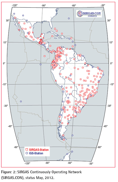
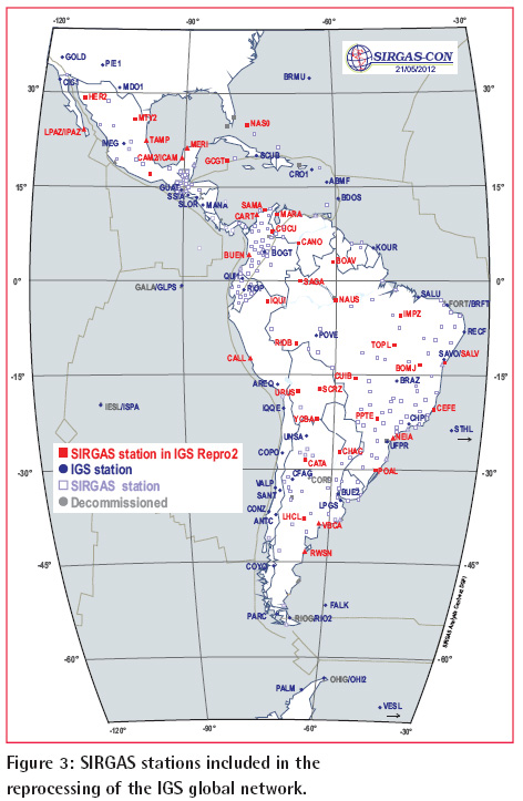
At present, SIRGAS-CON consists of more than 240 continuously operating GNSS stations (Fig. 2). Until the first years of this century, most of these stations were installed as part of research projects initiated and funded by foreign institutions, while local scientists were mostly involved in the collection of the data. This situation has changed dramatically during the last decade. Most national mapping/geodetic agencies now understand the need for upgrading their geodetic infrastructure and have begun the deployment of modern GNSS networks, including in many cases with real time capabilities. At present, 14 Latin American countries rely upon SIRGAS to realise their national geodetic reference networks, stations of which are integrated in SIRGAS-CON, and are maintained and data processed following international standards and specifications, particularly those of the International GNSS Service (IGS) and the International Earth Rotation and Reference Systems Service (IERS). Thanks to the operational and administrative efforts of the Latin American institutions responsible for the national reference frames, SIRGAS is today able to make available high quality, long time series observation data of about 40 regional stations, which will be included in the second global IGS reprocessing. This will enable the improvement of the International Terrestrial Reference Frame (ITRF), by strongly linking the northern and southern western hemispheres (Fig. 3).
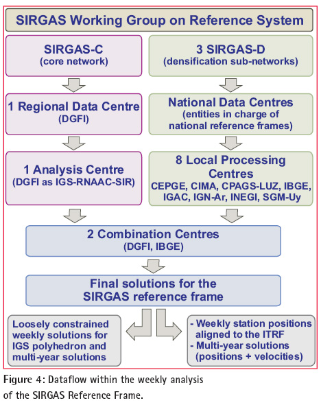
The installation and management of continuously operating GNSS stations has complemented an intense capacity building process that led to a strong involvement in the analysis of the data produced by SIRGAS-CON (Fig. 4). Today, SIRGAS-CON is divided into different sub-networks that are processed, on a weekly basis, by 8 analysis centres operated by: the Military Geographic Institute of Ecuador, the National University of Cuyo (Argentina), the University of El Zulia (Venezuela), the Brazilian Institute of Geography and Statistics, the Agustin Codazzi Geographic Institute (Colombia), the National Geographic Institute of Argentina, the National Institute of Statistics and Geography (Mexico), and the Military Geographic Service of Uruguay. The processing strategy satisfies all IGS requirements and guarantees that each station is included in three individual solutions. The loosely constrained weekly solutions produced by the analysis centres are combined in a continentally consistent solution aligned to the ITRF by two combination centres, one operated by the Brazilian Institute of Geography and Statistics and the other by the Deutsches Geodätisches Forschungsinstitut (DGFI – Germany). Having two combination centres, functioning independently in different institutions, improves quality control and redundancy of the final products delivered to the community by SIRGAS.
SIRGAS policy promotes the installation of (at least) one analysis centre per country, ensuring the development and sustainability of in-country capabilities to manipulate modern reference frames at the national level. Within this policy, SIRGAS encourages and supports the installation of experimental analysis centres, which are candidates to become SIRGAS analysis centres. During a specified probation period, they align their processing strategies to those required by SIRGAS and demonstrate their capacity for timely and regular delivery of weekly solutions. Once they satisfy these requirements, they may be appointed as official analysis centres. During this test period (at least one year), they process a set of SIRGASCON stations, however their solutions are not included in the computation of the final SIRGAS-CON products. Presently, the Military Geographic Institute of Chile is an experimental analysis centre, and the Geographic Institute of Bolivia and the National University of Costa Rica are this year preparing to become experimental processing centres.
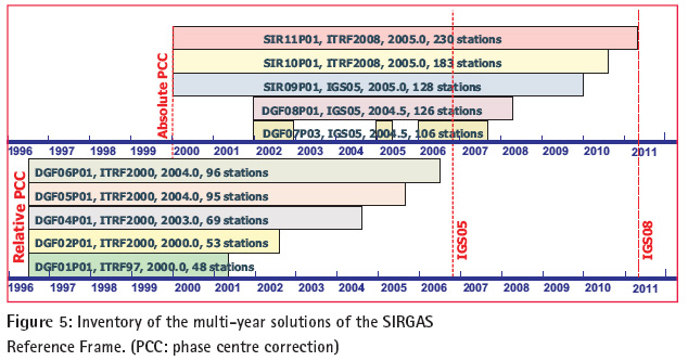
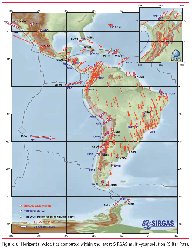
SIRGAS contributes to the IGS through the IGS Regional Network Associate Analysis Centre for SIRGAS (IGSRNAAC- SIR), operated by the DGFI. Since 1996 this centre delivers loosely constrained weekly solutions, that are combined together with those generated by the other global and regional IGS analysis centres, to form the IGS Polyhedron. In addition, state-of-theart multi-year solutions for the SIRGAS reference frame have been computed on an almost yearly basis (Fig. 5, Fig. 6).
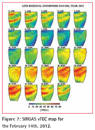
Since 2006, SIRGAS operates a service for computing regional ionospheric maps based on SIRGAS-CON observations (Fig. 7 ). The ionospheric model used by SIRGAS has evolved from a “thin layer” simplification for computing the integrated electron density to a formulation that represents the four-dimensional distribution of the electron density of the E, F1, F2 and top-side ionospheric layers. The SIRGAS maps of vertical Total Electron Content are being used for kind of studies, such as validating the International Reference Ionosphere (IRI) over the South American region, improving the performance of single-frequency GPS receivers, and testing the feasibility of computing the ionospheric corrections for a regional satellite based augmentation system (SBAS). SIRGAS is also contributing to the modernisation of the classical vertical reference systems. The main objective is to refer all existing physical heights to one and the same equipotential surface, which has to be defined and realised in a global frame with high precision. This demands a close collaboration with all colleagues working worldwide on this topic. During the four coming years, SIRGAS is participating in GGOSTheme 1 (Unified Global Height System) through activities carried out within the joint working group “Vertical Datum Standardisation”, a common effort of the Global Geodetic Observing System, the IAG Commission 2 (Gravity Field) and the International Gravity Field Service (IGFS).
The International Association of Geodesy (IAG) Response
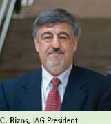 In my article “Geodesy: Out with the Old, In with the New”, published in Coordinates (vol. VII, No. 11, November 2011), the following sentence caused some controversy: “It must be pointed out however, that the representation of countries from South America, Asia and Africa, as hosts of GNSS tracking stations, as homes to product analysis centres, and on its governance body is disappointing.” I am pleased to see Claudio Brunini and Laura Sánchez respond with a very enlightening article on the development and current status of SIRGAS (Geocentric Reference System for the Americas). In my article “Geodesy: Out with the Old, In with the New”, published in Coordinates (vol. VII, No. 11, November 2011), the following sentence caused some controversy: “It must be pointed out however, that the representation of countries from South America, Asia and Africa, as hosts of GNSS tracking stations, as homes to product analysis centres, and on its governance body is disappointing.” I am pleased to see Claudio Brunini and Laura Sánchez respond with a very enlightening article on the development and current status of SIRGAS (Geocentric Reference System for the Americas).
In hindsight my words may have been ill-chosen, and perhaps a little harsh, and I apologise if they caused offense to my South American, Asian or African colleagues. Certainly progress in South America has been rapid, as the Brunini and Sánchez article explains very well. In fact SIRGAS is a successful example of regional geodetic cooperation in which, in addition to a number of objectives being met, the resulting institutions, expertise and linkage mechanisms have become permanent and self-sustaining. The SIRGAS experience in many ways mirrors the foundation of the International Association of Geodesy (IAG). Let us look back at the history of the IAG and tease out some lessons.
At the invitation of the Prussian General Johann Jacob Baeyer, representatives of the states of Prussia, Austria and Saxony met from 24th to 26th April 1862 in Berlin to discuss Baeyer’s “Proposal for a Central European Arc Measurement” (“Entwurf zu einer Mitteleuropäischen Gradmessung”). By the end of 1862, 16 nation states had agreed to participate in the project: Austria, Belgium, Denmark, France, seven German states (Baden, Bavaria, Hannover, Mecklenburg, Prussia, Saxony, Saxe-Gotha), Italy, The Netherlands, Poland, Sweden, Norway and Switzerland. The IAG counts this international scientifi c initiative, and the organisation it spawned, as its origin and is therefore celebrating its 150th anniversary this year.
In October 1864, the fi rst “General Conference of the Representatives to the Central European Arc Measurement” took place in Berlin. The organisational structure (Permanent Commission, Central Bureau, and triennial General Conferences) was agreed to and a research program was developed. The IAG considers this conference as its fi rst General Assembly. Baeyer was appointed Director of the Central Bureau and Peter Andreas Hansen appointed President of the Permanent Commission. The project extended rapidly to other European states and consequently the name of the organisation was changed in 1867 to “Europäische Gradmessung”, and in 1886 to “Internationale Erdmessung” (“Association Internationale de Géodésie”) with additional member states Argentina, Chile, Japan, Mexico, and USA. (The current name “International Association of Geodesy” was adopted in 1932.)
The past 150 years cover a remarkable historical era. From the mid-19th Century – with its social turmoil, national rivalry and endless continental wars – to the present day, characterised by technological wizardry and unprecedented levels of globalisation. That so many countries, in such a short time, pledged to work together, is an amazing achievement in itself. I have compiled some lessons that I believe can be drawn from this enterprise:
Strong personalities – administrators, government offi cial, military leaders, scientists, all contribute through expertise, drive and leadership.
Rationale for cooperation – a range of benefi ts were expected, including scientifi c results, engineering and practical outcomes, and the sharing of know-how and expertise.
Well defi ned structures – clear objectives, emphasis on operational and analysis guidelines, strong central bureau, signifi cant government “buyin”, and being well-funded, served the organisation well in its early years.
Active government agency involvement – critical early support by governments is mirrored by today’s crucial contributions by national mapping/geodetic organisations and space agencies.
Range of activities – promotion of “blue sky” research projects, by groups and individuals from different countries, as well as the development of standards and practical procedures, ensures the needs of multiple stakeholders are addressed.
Communications –publication of reports, convening regular conferences and encouraged networking amongst scientists and national agencies.
Strong scientifi c focus – the geodetic enterprise was (and still is) taking advantage of advances in data measurement technology and analysis theory, driving the generation of geodetic outputs of ever improving quality.
Service oriented – what drove the establishment of the IAG still holds today, that its outputs can be applied in the service of science and society.
Adaptability – as circumstances change, the organisation and its objectives, structures and rules must adapt.
We can see from the Brunini and Sánchez article that SIRGAS exhibits many of the characteristics of a long-lived institution such as the IAG. The will to cooperate with other countries, to share experiences, expertise and data, are necessary conditions, however not suffi cient conditions. What is required is a change in mindset – from local or national perspective to one that is regional and global – implying a deep cultural change. Competing countries become cooperative nations.
Baeyer died in 1885, and under his successor, Friedrich Robert Helmert, the Central Bureau moved from Berlin to Potsdam, together with the Geodetic Institute, which is the predecessor of today’s GeoForschungsZentrum (GFZ) at Potsdam. Against all odds the IAG survived two World Wars, evolving in the process, and becoming part of the International Union of Geodesy and Geophysics (IUGG) after its establishment in 1919. For more details the reader is referred to an excellent article by Torge (2005).
It must be acknowledged that the (perhaps utopian) goals of close European cooperation and unfettered sharing of geodetic data were not substantially achieved until well after WWII. However, in the past few decades the IAG has “come full circle”, and is again strongly promoting increased global collaboration in order to advance the practice and science of geodesy. The SIRGAS enterprise therefore shares the original ideals of the IAG, and at the same time is a positive example of the relevance of Modern Geodesy – the application of advanced geodetic technologies to address the needs of science and society. It is hoped that the SIRGAS geodesists will share their experiences with colleagues in other parts of the world, where tight regional-level cooperation still more an aspiration than a reality. That will require SIRGAS geodesists to play a larger role in global geodesy by, for example, leading and contributing to IAG components (Commissions, Sub-Commissions, Working Groups, Services, etc).
To celebrate its origins, the IAG will hold its regular quadrennial Scientifi c Assembly in 2013, between the dates of its foundation and the fi rst General Conference of the Mitteleuropäische Gradmessung, in Potsdam and Berlin.
Torge, W.: The International Association of Geodesy 1862 to 1922: From a regional project to an international organization, Journal of Geodesy (78): 558-568, 2005. |
Besides the SIRGAS participation in the IAG Commission 1 (as Sub-Commission 1.3b), the IGS-RNAAC-SIR and GGOS-Theme 1, SIRGAS contributes to the IAG Commission 1 working group on “Integration of Dense Velocity Fields into the ITRF”, the IGS working group TIGA, the IAG Commission 1 working group on “Deformation Models for Reference Frames”, the IAG Commission 1-IERS-ICTT joint working group “Strategies for Epoch Reference Frames”, and the IAG Commission 4 study group “Ionosphere Modelling and Analysis”. Up-to-date and detailed information about SIRGAS, its achievements and challenges, can be obtained from the organisation’s web page (www.sirgas.org) and, among others, the following papers recently published in S. Kenyon, M.C. Pacino, U. Marti (Eds.), “Geodesy for Planet Earth”, IAG Symposia, Vol. 136, Springer 2012:
Brunini, C., F. Azpilicueta, M. Gende, A. Aragón-Ángel, M. Hernández-Pajares, J.M. Juan, J. Sanz: Toward a SIRGAS Service for Mapping the Ionosphere’s Electron Density Distribution, 753-760.
Brunini, C., L. Sánchez, H. Drewes, S. Costa, V. Mackern, W. Martínez, W. Seemüller, A. da Silva: Improved Analysis Strategy and Accessibility of the SIRGAS Reference Frame, 3-10.
Costa, S.M.A, A.L. Silva, J.A. Vaz: Processing Evaluation of SIRGAS-CON Network by IBGE Analysis Center, 859-867.
Costa, S.M.A., A.L. Silva, J.A. Vaz: Report on the SIRGASCON Combined Solution by IBGE Analysis Center, 853-858.
Drewes, H., O. Heidbach: The 2009 Horizontal Velocity Field for South America and the Caribbean, 657-664.
Sánchez, L., W. Seemüller, M. Seitz: Combination of the Weekly Solutions Delivered by the SIRGAS Processing Centres for the SIRGASCON Reference Frame, 845-852.
Seemüller, W., M. Seitz, L. Sánchez, H. Drewes: The new Multi-year Position and Velocity Solution SIR09P01 of the IGS Regional Network Associate Analysis Centre (IGS RNAAC SIR), 877-884.
|
|
|
|
My Coordinates
|
|
|
Mark your calendar
|
|
|
News
|
|
|


 (6 votes, average: 2.00 out of 5)


Leave your response!