| GNSS | |
Galileo Technology Centre
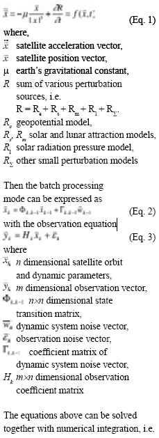
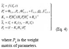
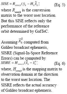
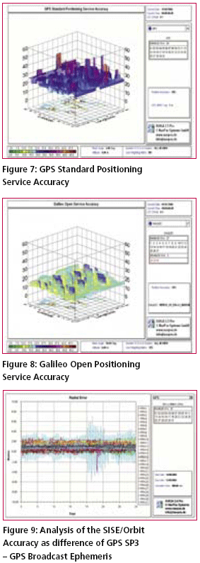
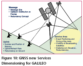
Reference OD&TSThe reference orbit determination and time synchronisation (OD&TS) is a very important component for GalTeC. It provides the precise reference orbit for further data analysis and processing. The reference orbit determination is performed in GalTeC using raw measurements from GSS stations and monitoring station networks like IGS (International GNSS Service). Also GalTeC own ground stations will collect pseudo-range and carrier phase measurements and provide them offline to GalTeC for further data processing. The major processing steps of reference orbit determination can be illustrated as in figure 5 and 6. The Galileo or generally GNSS satellite orbits are determined using the dynamic method in batch processing mode. Assuming the satellite movement equation is GalTeC can compute the so-called SISE (Signal-in-Space Errors) as follows SISRE is a key performance parameter which can be used for monitoring and validation of the performance of the Galileo broadcast orbit. Based on SISRE, another key performance parameter, SISRA\ (Signal-in-Space Reference Accuracy) can also be computed. SISRA is a minimum standard deviation of the unbiased Gaussian distribution over-bounding SISRE. SISRA can be directly compared with Galileo broadcast SISA and SISMA. Service Level PredictionFor the prediction of the system performance and also for the design and dimensioning of the GNSS Services a simulation function is needed. For this purpose, the NavPos Systems Service Volume Simulator AVIGA® will be used and further developed to a GalTeC Prediction tool in the frame of the GalTeC project. The prediction tool offers the means to predict, analyse and evaluate Galileo Services. A main AVIGA Objective shall be the analysis of the GNSS performance at the user using simulation data. AVIGA offers to run the simulation analysis at point, over area and along routes in terms of In addition, AVIGA shall allow to analyse the GNSS constellation performance in terms of AVIGA simulation will be composed of modules, which will fulfil the following tasks: Space Segment Module: predicts satellites trajectories from standard almanacs, e.g. Almanac YUMA files, computes satellite trajectories from user – defined Keplerian elements; Broadcast Ephemeris or SP3 Precise Ephemeris. Visibility Module: evaluates visibility characteristics of satellite coverage accounting for mask skyline angles; DOP (or Geometry) Module: evaluates DOP and Position Error characteristics of satellite coverage, position accuracy is estimated from the position errors covariance matrix. Availability Module: evaluates availability of DOP and position accuracy. Models of satellite outages and navigation solution errors are used in this model. Integrity/ Continuity Module consists of sub modules which can be also considered as independent modules: RAIM: evaluates availability of the snapshot RAIM FD/FDE methods. SBAS: evaluates availability of the SBAS Protection Levels. Galileo: evaluates availability of protection level according to concept proposed for Galileo system, calculates the pertaining Integrity Risk. Availability of Integrity Risk: analyses availability of Integrity Risk according to concept proposed for Galileo system GBAS/Galileo LE: analyses performance of GPS, Galileo based LAAS systems Route Module: analyses performance along a specified route SISE Analysis Module: assesses satellite orbital and clock errors from SP3 and RINEX Navigation files. Further modules which will be implemented or extended as part of GalTeC Phase II Data Dissemination Module: simulates disseminating of Galileo Messages from Ground Mission Segment via ULS network to world-wide or regional users. End-to-End Service Volume Simulation: This module will allow error components simulation on Galileo element level to analyse the Galileo Service performance and the impact of various errors sources. The prediction of the Galileo Services according to their specification, and also with further parameter settings, shall be done with the GalTeC Prediction Tool. The tool shall also allow the simulation of seldom failures of the system such as erroneous behaviour and outages. Figure 7 and Figure 8 show examples of the GNSS Services Accuracy Performance prediction for the GPS SPS and the Galileo OS. A further very important parameter for the performance assessment of the Galileo Safety of Life Service is the Signal in Space Error (SISE). For the provision of Galileo integrity, the main role is assigned to the integrity flags which are generated in the Integrity Processing Facility. The generation of integrity flags is based on the determination of SISE in real time. The value of SISE depends on the number of ground sensor stations (GSS) and the satellite to GSS errors. A further means to determine and evaluate the SISE performance is done in post-processing. Figure 9 shows the difference between the GPS/SP3 reference orbit and the Broadcast Ephemeris data which were broadcast in real-time. The Prediction Tool shall be used for the dimensioning of services and for the performance assessment in relation to the needed signal bandwidth. The signal bandwidth will probably play an important role in the service transmission cost estimation. The design and dimensioning is needed for the feasibility and cost estimation of a service. An application example for GalTeC will be to offer Service Providers the possibility to check needed data volume and distribution strategies for their planed Services. The GalTeC Service Volume Simulation and Level Prediction Tool offers the means to predict, analyse and evaluate Galileo Services. |




 (No Ratings Yet)


