
| Interviews | |
Empowering Planners, Not Algorithms: Leveraging AI as an Advisory Tool
In an interview with Coordinates, Prof. Dr. Mahavir and Dr. Prabh Bedi explore how AI and geospatial technologies could reshape urban planning – from the conceptualisation of city plans and scenario generation to master-plan preparation, approval, public participation and the emergence of City Digital Twins. At the same time, they also caution against assuming that technology alone can solve the complexities of planning |
 |
|
 |
|
Urban planning traditionally begins with analysing land use, infrastructure, demographics, and environmental constraints. With AI and geospatial intelligence now available, how do you see the conceptual stage of city planning evolving?
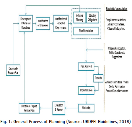
Well, not as simple as that! It starts with the formulation of goals and objectives, vision statements, demography, land availability, land features, thresholds, and regional considerations. It is a continuous, time oriented process where planning, implementation, monitoring, review and plan updating go on as a dynamic cycle (Fig. 1). Planning had become dynamic when computer-based GIS was integrated into it. Planning had transformed from a static and linear process into a dynamic system with the incorporation of RS and GIS into its fold; Geospatial Artificial Intelligence (GeoAI) shifts it further towards a continuous workflow. It also depends upon whether we are talking about planning for an existing city or a greenfield development. Further, at what scale of planning, i.e., a site, neighbourhood, zone/ sector, city or a region. Planners can now instantly simulate thousands of scenarios across overlapping datasets like human mobility and climate constraints. Instead of preparing a single master plan, large Geospatial models allow planners to input specific textual requirements e.g., increase housing density or FAR or green spaces and instantly generate multiple viable alternative plans.
Rather than relying on periodic census surveys, which already have poor temporal resolution (as compared to urban dynamics) and can be further delayed, as is the case presently in India, the conceptual stage is now driven by indirect population indicators as realtime (validated) data, including GPS traces, IoT sensors, and mobile signals. This highlights actual functional flows and collective human behaviours. Geospatial AI platforms can process thousands of data layers (static and nonstatic) – topography, zoning, and market context – so planners can immediately evaluate which plans improve traffic, optimise infrastructure, or increase land value before the actual planning begins.
Core Geospatial technologies driving this shift are Generative Urban AI and Advanced Geospatial Analysis. Advanced computational models with hybrid intelligence architecture are now capable of analysing diverse data streams to interpret dynamic social behaviours. Systems are designed to encode multifaceted conditions into structured embeddings to guide generative models. This aspect is more attuned towards urban management, at least in the current space and time. To be able to incorporate it as a planning input, a continuous data stream aggregated over broader timelines (maybe 10 years at least for development plans) would be required.
Integration of Geographic Information Systems (GIS) with machine learning instantly models urban dynamics, anticipates urban sprawl, and optimises land uses. Some more quick applications that come to mind include resolution between conflicting and competing land uses while planning; identification of lands having potential for encroachments in future; predicting directions of growth; performing spatial SWOC analysis; detailing the spatial phasing of plans, etc.
You mentioned the levels and scales of planning. How can Geospatial AI help in providing a seamless transition between different scales and levels of (urban) planning in terms of data and plans?
Geospatial AI (GeoAI) acts as an analytical bridge in urban planning by continuously aggregating, downscaling and interpreting multi-source data. It resolves disconnects between macro-level regional policies and micro-level site designs, creating dynamic, data-driven planning frameworks. The transition between these scales can be achieved in several specific ways, such as Seamless Data Aggregation and Downscaling, Multi-Level Scenario Modelling and Digital Twins, Policy and Regulatory Translation, and Human-Centric Planning.
GeoAI resolves conflicting scales by utilising advanced deep learning models to convert macro-datasets (e.g., regional satellite imagery and census data) into hyper-local, block-level insights (e.g., predicting exact building uses and demographics at neighbourhood level). GeoAI integrates diverse layers – such as IoT sensor data, mobility traces, and socio-economic indices – so planners have a consistent foundation of realworld awareness, whether analysing an entire city or a small site. GeoAI can automatically extract unstructured data like building footprints and road networks from high-resolution aerial and LiDAR data, obtained through drones or otherwise, continuously updating local databases in real-time.
GeoAI can feed region-wide macroeconomic and environmental forecasts into hyper-local models. This creates Urban Digital Twins, allowing planners to simulate how zoning changes at the city level impact micro-scale issues like urban local flooding, heat islands or traffic bottlenecks. Feeding broader goals (e.g., net-zero emission targets or mass-void ratios) into generative AI tools can instantly evaluate and generate thousands of localised 3D urban layouts compliant with those macro-level targets.
GeoAI can interpret complex, lengthy policy documents using Natural Language Processing (NLP) and vector search and overlay them onto 3D mapping environments. This allows planners and decision-makers as well to visualise whether region-wide master plans for density or environmental protection are feasible at the neighbourhood and lower levels. Agent-based models driven by Large Language Models (LLMs) that simulate human behaviour can be employed to evaluate proposed spaces from a micro-scale pedestrian perspective to test street vibrancy, walkability, and safety across the entire city’s network. By decoding the spatial patterns of past land uses, GeoAI models can predict future developmental pressures and directions. Planners can dynamically adjust macrozoning laws based on these forwardlooking spatial models, avoiding the limitations of static, outdated master plans. Tools such as UrbanistAI allow citizens to easily visualise and propose local, street-level changes via prompts. Planners can seamlessly integrate these community inputs into larger, topdown policy configurations to ensure multi-scale stakeholder concerns.
Remote sensing and GIS have been important tools in planning for decades. With the rise of GeoAI, do you see a shift from analytical tools towards intelligent planning systems that can support or even anticipate planning decisions?
Absolutely. A basic paradigm shift from GIS as a system of record (which stores, displays, analyses and answers what currently exists) to GeoAI as a system of intelligence (which learns spatiotemporal dynamics to sketch, predict, and anticipate spatial planning outcomes).
Several key technological shifts are making this possible. Automating labour-intensive tasks through machine learning and computer vision instantly automates tedious workflows like landuse classification and building footprint extraction, freeing planners to focus on strategy and community engagement. Planners can now use tools like NASA’s Prithvi geospatial foundation models and Esri’s ArcGIS deep learning pipelines to automatically forecast urban sprawl, model traffic congestion, and simulate flood zones in near-real-time. Once popular simulation models like SimCity are now progressing to predictive simulation. By merging spatial data with IoT sensors and socio-economic variables, GeoAI can anticipate which utility assets (water and gas pipes, road networks) are most at risk of failing before it happens, optimising maintenance budgets and delays. Being predictive, GeoAI is likely to become a more enhanced and robust tool than existing RS and GIS, enabling planners to take more informed decisions. Since the output of GeoAI will be based on a varied set of data, rigorous analysis and faster response time, it will cause planners’ decisions to be indicative and logical.
One of the limitations of conventional master planning has been its static nature. Could GeoAI enable planners to simulate multiple urban futures and move towards dynamic or continuously selfevolving city plans? Can City Digital Twins be helpful? How can Geospatial AI help prepare and apply City Digital Twins?
GeoAI can actively revolutionise urban planning by replacing outdated, static master plans with dynamic, data-driven simulations. By leveraging city digital twins and advanced machine learning, planners can now continuously model multiple urban futures and create living city plans that evolve alongside socioeconomic and environmental changes. Geospatial AI transforms static Master Plans into dynamic, self-evolving frameworks by integrating real-time data with predictive spatial modelling. GeoAI processes high-resolution satellite imagery and LiDAR to continuously monitor urban expansion and detect unauthorised constructions automatically. Planners gain instant visibility through spatial data-driven Real-Time Morphological Tracking, i.e., how a city is morphing rather than waiting for surveys. It shifts planning from rigid 20-year documents to responsive systems, continuously updated to adapt to urban growth, population shifts, and climate vulnerabilities. Selfevolution can help break the 20-year plan period into shorter periods, say 5-year plans. It is noteworthy that the shift from a 20-year plan to a 10-year (or lesser) plan is more a derivative of urban dynamics than GeoAI. GeoAI has the tools facilitating this shift. GeoAI can function as a core in the process of integration of plans at regional, subregional, urban area/ city, sub-city/ zone, neighbourhood and site levels, along with cross-functional plans like environmental, transportation and traffic plans. However, its success remains in the purview of the planners through a functional institutional framework and adoption of GeoAI tools in the plan preparation. Planning has various cyclical stages, broadly: preparation, implementation, monitoring, feedback, and again plan preparation. Amongst these GeoAI will have a role to play in varying degrees, in some stages more than others. While projecting the future, these self-evolving plans will keep a connect with the past heritage, history and land uses and other planning policies in the case of plan preparation for existing cities.
GeoAI takes in real-time data from IoT sensors, mobility systems, and environmental monitors to build highly accurate virtual replicas of cities. These digital twins allow planners to test ‘what-if’ scenarios for traffic congestion, housing demands, and climate change in real time before building in the physical world. Advanced GeoAI allows planners to use ‘generative agents’ (Agent-Based Modelling) that simulate human-like behaviour, such as shopping, pedestrian movement, and commuting preferences.
As you rightly pointed out, one of the main criticisms of existing master plans is their rigid and static nature. Rather than a city plan being a rigid document that is updated typically every 20 years, GeoAI integrates a feedback loop where real-world outcomes continuously refine the simulation. As urban demographics and economic landscapes shift, the spatial-digital framework automatically adapts, allowing planning bodies to make proactive, evidence-based policy adjustments rather than reacting to crises. These spatial data-driven master plans rely on several core mechanisms, viz. predictive scenario modelling, dynamic spatial digital twins, and climate and vulnerability integration, etc.
City Digital Twins model environmental factors like the Urban Heat Island (UHI) effect, helping planners design green spaces that maximise cooling and reduce carbon footprints. Planners and private developers can model the full impact of new private residential townships (as in the case of Bengaluru) or zoning changes before it takes shape on the ground.
GeoAI transforms static 3D city models into dynamic city models by automating data preparation and powering predictive scenario simulations. It acts as the intelligent engine that turns raw data into functional urban planning ecosystems. The model analyses satellite and drone imagery and LiDAR scans to automatically identify and classify physical features such as roads, building footprints, trees and utilities. For instance, AI can process massive urban areas and model thousands of buildings in minutes. Huge amount of multisource, spatial, attribute and aspatial data is then synthesised and stitched together into standard GIS layers.
AI algorithms infer properties about unmapped assets, adding semantic context (e.g., estimating the age, material, or function of a building) to the 3D models. Once prepared, GeoAI transitions the digital twin from a static 3D visualisation into a predictive tool for urban management. Besides planning, GeoAI can examine building permit applications against a city’s zoning and other bylaws and instantly visualise the proposed building’s shadow, height, and line-of-sight impacts on the digital twin. It can further visualise the impact on neighbourhood density or the overall built space, or on the infrastructure. It can also facilitate an urban designer to visualise the overall built form and scale it up or down at other levels of planning.
Cities today generate massive volumes of spatial data – from satellites, sensors, mobility platforms, and administrative databases. How can planners effectively integrate and interpret these diverse datasets at various stages of planning?
Planners integrate spatial data through Geospatial Digital Twins, which fuse realtime IoT sensors, satellite imagery, UAVdrones, and administrative databases into a single living model. This allows cities to shift from reactive planning to predictive, spatial data-driven management across all project phases. Planners can use AI algorithms combined with GIS spatial mapping to assess environmental risks (e.g., flood zones), proximity to transit, and land-use mix simultaneously. Mobility platforms and smart traffic cameras feed live data into predictive simulation models. Planners can virtually reroute traffic or trial new transit lines to measure impacts before real-world implementation. This can be particularly effective in deciding optimum stations for TOD.
Digital Twins at different levels can transform flat, static maps into immersive 3D/4D models. This visual context makes complex data much easier for community members and government leaders to understand, fostering public trust and collaborative and evolutionary decision-making.
It is reasonable to mention that this hi-tech situation in India exists in metropolitan cities or maybe Class I cities. The intent should be that the benefit of these tools is experienced by smaller towns as well, though their models will need to be adapted to their conditions using the data of these small towns. Achieving this will not be easy, especially considering funding, institutional and political issues, but it must be remembered that it can not be one (GeoAI) model fits all.
Can Geospatial AI reduce overall Master Plan preparation time in terms of data collection, data analysis and projections?
Planning is a team effort with planners from varied backgrounds, such as architecture, economics, geography, sociology, and environmental sciences, etc. So are the various fields from where data is fed into a master planning process. Geospatial AI (GeoAI) accelerates Master Plan preparation by integrating these data and fields, replacing manual, time-intensive tasks with automated workflows. It slashes months from traditional timelines through rapid data processing, intelligent pattern recognition, and scenario generation.
AI computer vision models can automate feature extraction by instantly extracting building footprints, road networks, green cover, and water bodies, etc. from satellite imagery and LiDAR, replacing months of extensive field surveys and manual digitisation. GeoAI can act as a ‘universal translator’, decoding fragmented, mismatched public data from various civic departments into uniform GIS layers, saving countless hours of data sieving and formatting. It can rapidly compare historical and current aerial imagery to identify urban sprawl, unauthorised developments, and land use changes over time.
GeoAI can literally reproduce and analyse all the spatial parameters (for example, those suggested by McHarg and many more) by quickly modelling machine-learned Land Suitability overlays with multiple variables -such as terrain, transport access, and proximity to utilities, etc. to instantly flag optimal areas for development versus high-risk environmental zones. Using historical mobility, demographic, and economic data, GeoAI runs predictive simulations to forecast spatial growth and predict future congestion hotspots. The ripple effects of proposed zoning changes or new infrastructure on population density can be developed in seconds, even before real-world rollout.
Can Geospatial AI reduce overall Master Plan approval time also, typically in India?
Yes, it’s not only the preparation time but also the overall time taken in the process of inviting and incorporating public opinions and objections, deciding upon and incorporating the valid and feasible ones, and the necessary approvals. Master Plan for Delhi – 2041, for example, though first notified in 2021 for inviting objections/ suggestions, has taken 5 years to finally approve and notify for the Perspective Year 2047 (MPD2047). With better plan preparation, more alternatives, especially with ‘what if’ scenarios, Geospatial tools for better public participation and better vertical and horizontal integration, the overall time is bound to be reduced.
GeoAI can substantially reduce the Master Plan approval times by bypassing traditional bureaucratic bottlenecks and enabling instant, data-driven compliance reviews. Better reasoning supported with geospatial data (trends as well as current and projections), alternative plans with pros and cons of ‘what if’ scenarios, including feasibility and social-environmental-economic cost-benefits, help faster decisionmaking and the approval process. GeoAI evaluates environmental and infrastructure impacts, creating 3D visual models that allow authorities and stakeholders to assess proposals in a short period of time, streamlining both review and public consultation.
How can Geospatial AI help in generating alternative scenarios instead of just one Master Plan?
Traditionally, we have been creating just one Master Plan due to lack of time, real-time data, resources, and the very complex nature of considerations. This further delays the processes of public engagement and approvals, as the only option we offer is ‘take it’ or ‘leave it’. Yes, suggestions from the public and the decision makers are incorporated, but the base template remains the same. GeoAI transforms traditional planning by shifting from single, static, linear plans to more dynamic, ‘what-if’ simulations. Instead of delivering just one rigid master plan, GeoAI automates the iteration process to rapidly evaluate several alternative future scenarios based on real-time data and specific policy guidelines. Options offered with associated pros and cons strengthen the logic behind major proposals and hence make it easier for the decision maker to choose the most optimal. It also reduces biases on both the planners’ side as well as the decision maker’s side.
Planners input strict, non-negotiable rules (e.g., desired land use percentages, FAR constraints, density targets, zoning bylaws, etc.), and the GeoAI generates several plan proposals with related maps. Inputs from the supporting fields like Urban Design, Environment, Heritage, Landscape, Disaster Management, Social justice and equity can also be incorporated not as an appendix but as a foundation. Alternative infrastructure mappings can also be generated proactively. Stakeholders and citizens can interact with the system using simple prompts to instantly generate and visually compare alternative zoning or neighbourhood maps. Esri ArcGIS and Autodesk Forma are providing these GeoAI-driven capabilities. Planners can simulate a new metro line to see how it affects local land uses and property values, accessibility to jobs for low-income areas, and localised emissions simultaneously.
How can Geospatial AI provide better integrity between different aspects of planning, like social, economic, environmental and infrastructure?
GeoAI breaks down data silos by synthesising massive, multi-dimensional datasets into a single, location-based intelligence platform. By adding geospatial context to machine learning algorithms, it solves the challenges of cross-sector evaluation, allowing planners to optimise complex trade-offs across social, economic, environmental, and infrastructure domains. Isolated datasets like census data, real estate prices, utility networks, and satellite images are anchored to precise geographic coordinates. This enables a unified, spatial database where actions in one sector are immediately evaluated against impacts in others. GeoAI also takes care of the spatial data available at different scales of mapping.
GeoAI models perform analysis on real-time IoT sensor networks and continuous satellite feeds to automatically identify and map urban heat islands, monitor air quality, and predict areas vulnerable to flooding. This pinpoints exact zones where expanding blue-green infrastructure will yield maximum results. The UN-Habitat GeoAI Toolkit provides methods for planners to integrate spatial analysis into their decision-making, ensuring social inclusiveness and climate resilience. Spatial analysis platforms like Esri Geospatial AI can be used to run automated land use mapping, monitor climate risk, and maintain up-to-date, digitised urban infrastructure inventories. More importantly, GeoAI can help bring the health and QoL aspects (Geddes, Howard, etc.) back into planning.
India is urbanising rapidly and faces challenges such as congestion, environmental stress, and informal growth. Could AI-enabled geospatial systems help planners address issues like climate resilience, flood risks, and urban sprawl more effectively?
Yes, AI-enabled geospatial systems are highly effective tools for managing India’s rapid urbanisation. By integrating satellite imagery, IoT sensors, and local data, these systems provide planners with predictive models to tackle climate resilience, flood risks, and urban sprawl. However, besides the technology, the state needs to formulate and implement a National Urbanisation Policy, including counter-urbanisation in some areas, a population and migration policy and a strong directive for preparing regional plans not only for major cities but for regions defined based on political boundaries, if not geographical, social and economic entities.
GeoAI maps terrain, drainage networks, and historical weather data to run hyperlocal flood simulations. One of the major problems in urban areas today is waterlogging due to intense rainfall, which can be addressed using predictive GeoAI models and tools to augment the infrastructure and be prepared with mitigative measures, such as identifying vulnerable neighbourhoods in floodprone cities like Mumbai and Bengaluru before disasters strike. Algorithms evaluate optimal locations for Blue-Green Infrastructure like urban forests, wetlands, and permeable surfaces to reduce heat stress and mitigate urban flooding. Models process real-time data streams of satellite imagery to monitor city peripheries and sprawl. The same is true for informal settlements and conversions of agricultural land and green belts.
GeoAI-driven systems may increasingly shape urban policy and planning choices. How should planners ensure transparency, accountability, and trust in such technologies?
Transparency, accountability, and trust are very important. Human-in-theloop (HITL) oversight requiring public algorithmic audits and adopting opensource civic tech prevent ‘black box’ decisions, combat systemic biases, and ensure that technology augments rather than replaces democratic decisionmaking. While GeoAI can interpret and structure data, final decisions must remain with professional, accountable, ‘human planners’ who understand local sociopolitical realities. Robust data privacy measures that adhere to global or local national data protection standards should be implemented, ensuring constituent data is anonymised and securely managed. Reasoning and arguments for developing and adopting a particular vision for planned development, or trends of population growth or spatial spread, though, can be relied upon various GeoAI models, must be owned and defended by ‘human’ planners and decision makers. As regards trust, we will repeat what Dr. Mukund Rao said, “Trust, but Verify” Rao, MK (2026).
Do you see any risks and challenges that excessive reliance on AI could lead to technocratic planning, where algorithms dominate human judgment and local knowledge?
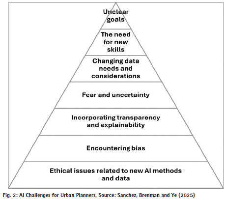
Yes, the risk of shifting toward algorithmic governance is substantial. Excessive reliance on AI can lead to technocratic planning, where opaque models and narrow performance metrics override human values. Over-reliance threatens human oversight, marginalises vital local knowledge, and can lead to automation bias. Algorithms might fail to capture the nuanced realities, cultural subtleties, and specific context of local communities. There is a danger of decline in critical thinking skills and the atrophy of human expertise. AI systems should not be allowed to ‘make’ critical decisions; rather, they should aid in making a decision. Governance structures must enforce a human-centric approach to preserve human values, judgement and local knowledge. There are ethical and ownership issues as well. It must be acknowledged that the models may not be structured to reflect local conditions and nuances, which can be provided only through the intervention of the planners. A summary of challenges, as identified by Sanchez, Brenman and Ye (2025) is presented in Fig. 2.
How can Geospatial AI provide better horizontal and vertical integration between different levels of planning?
GeoAI provides better horizontal and vertical integration in planning by acting as a universal, spatial data translator. It enables cross-sector communication (horizontal) and connects local, urban, regional, and national goals (vertical) by transforming massive datasets into shared, predictive, and interactive planning models.
Planners can query unstructured administrative documents, policy guidelines, and spatial maps simultaneously using tools within enterprise ecosystems like ArcGIS, allowing domain experts without coding backgrounds to interact with multi-level datasets. By evaluating historical zoning, socio-economic layers, and development trends, GeoAI algorithms can accurately forecast where future infrastructure strain will occur, ensuring long-term city-level plans align with local neighbourhood or zonal level plans. Ideally, it is possible to seamlessly plan and flow through the local level plans to the city and regional level plans and viceversa, typically like one would zoom in and out in Google Maps. In the same way, comparison and integration are possible between neighbouring wards or zones, etc
How can Geospatial AI ensure better stakeholders’ participation at each stage of Master Plan preparation – opinion and objections, plan preparation, and feedback?
Stakeholders’ participation is an important stage in the planning process. But before the stakeholders can react, they must understand the plan proposals from the policy and layout perspectives. Gathering public input is traditionally hindered by technical jargon, complicated zoning maps, and overwhelming administrative data. Ideally, the stakeholders themselves should be able to generate ‘what if’ scenarios based on their suggestions. GeoAI transforms a Master Plan from a top-down techno-administrative process to an inclusive, data-driven and comprehendible framework. It bridges the gap between experts and citizens by making complex spatial data intuitive, automating public input analysis, and ensuring that community feedback is accurately reflected at every stage of the planning process. AI Natural Language Processing (NLP) translates dense techno-administrative planning text into simpler, local languages and accessible terminology, ensuring all residents understand how the plan proposals are going to affect their overall quality of life. When citizens submit feedback or drop location-based pins on maps (Public Participation GIS), GeoAI automatically analyses the text and categorises the data by specific themes like land use compatibility, congestion, green spaces or historical aspects. Instead of manually reading thousands of localised objections and suggestions, GeoAI tools immediately sort and summarise complex feedback to differentiate between localised voices and those at the city level.
During the plan preparation stage, GeoAI acts as a real-time consensus and visualisation tool, bridging the gap between community needs and physical land use mapping. Complex 2D layers can be converted into 3D/4D visualisations, allowing all stakeholders to intuitively view how master plan proposals, new infrastructure, or changing building heights will look in their neighbourhood. Interactive GeoAI platforms enable planners to adjust draft plans live during community workshops. If residents request more parks, the system calculates the impact on connectivity and accessibility in real time, fostering an environment of co-creation rather than one-way communication. A similar process can be followed for periodic reviews and feedback.
The final check ensures the draft master plan accurately aligns with the thousands of opinions before it is finalised. GeoAI can facilitate consensus by grouping draft outcomes based on community preferences, ranking proposed solutions, and building automated dashboards that verify which public objections were integrated into the finalised master plan. Interactive mobile-based or internetbased apps can be developed to generate alternative scenarios for the suggestion being made. AI algorithms can segregate large volumes of unstructured public comments into organised, geo-referenced, quick-mappable solutions. These tools can expose structural inequalities and help evaluate whether the feedback captures a representative demographic group.
How can Geospatial AI help prepare app-based tools for public participation in the Master Plan preparation process?
App-based tools can ensure public participation in Master Plan preparation by automating data synthesis and making complex spatial data intuitive. It allows citizens to interact directly with urban planning data, analysis and plan proposals. AI-powered chatbots and Natural Language Processing (NLP) within apps can automatically translate complex, technical planning statements into simple, locally understood language for residents. Using 3D models and augmented reality, citizens can view and interact with proposed zoning (like mixed-use) or FAR and building height proposals in realtime, helping stakeholders easily grasp the impact of proposals. These models can also easily classify existing land use, creating a baseline map of current activities so the public can review spatial plans against current ground realities. Tools like UrbanistAI can help users to suggest public space designs on interactive maps using text prompts and visual generation. App dashboards can be used to model scenarios. GeoAI models can analyse proposals to show how close the citizens would be to public amenities, allowing them to spot and highlight service gaps at a neighbourhood or zonal level.
Urban Planners were late in adopting technology in general, especially the Systems Approach to Planning. Please elaborate.
Urban planners were historically late in adopting technology, primarily because the profession originated in engineering, public health and architecture, focusing on physical aesthetics rather than empirical data. Early urban planning was treated as an artistic and spatial design process. Planners mapped physical layouts and were slow to integrate the social, economic, and digital data required by a systems perspective. At the same time, planners lacked the mathematical and computational training to handle complex, cybernetic urban models. The Systems Approach conceptualised the city as a complex, interconnected organism – where transportation, housing, economics, and ecology influence one another. When technological tools and the Systems Approach emerged in the late ‘60s (Chadwick, Hall, McLoughlin), the profession resisted them, viewing these methods as overly technocratic and dismissive of human complexity. Gradually, cities were viewed as Generators of Economic Momentum (GEM; NCU) and Engines of Growth rather than a place to live with a certain Quality of Life. With the availability of raster-based satellite images and GIS, early attempts were made to predict growth and sprawl based on the fractal geometry of cities (Batty and Longley). Smart Cities Mission further pushed the technology aspect rather than the environment and quality aspect. However, the GeoAI technology of today can very efficiently merge statistical and spatial data, technical and humanistic considerations, environment and Quality of Life concerns, both for understanding the present and forecasting the future.
How can GeoAI and Agentic GIS help make better statistical and spatial projections and prepare better Master Plans for urban areas?
Geospatial AI (GeoAI) combines artificial intelligence with geographic information systems (GIS) to process satellite imagery, IoT sensors, and spatial data. Rather than estimating growth based solely on historical flat statistics, GeoAI combines demographic shifts, economic data, and satellite imagery to forecast population changes and map future demand for resources like land and infrastructure. Reasonably accurate estimates of population can be made in the absence of frequent or delayed census data. Not only the population in aggregate but also how the population is distributed over zones or wards, etc. It can automatically process drone and satellite imagery to map urban heat islands, calculate green cover loss, or predict flood zones and at-risk households. Geospatial AI (GeoAI) and Agentic GIS transform traditional urban planning by replacing static master plans with dynamic, data-driven systems. These technologies allow planners to automate complex workflows, predict urban growth, and analyse vast, multimodal spatial datasets in minutes rather than months. Also, self-evolving shorter-term plans can be prepared at various spatial levels.
Agentic GIS uses specialised AI agents that break down complex goals into smaller steps, autonomously fetch necessary geospatial data, analyse it against constraints, and output recommendations. Archivinci, CARTO and Mapbox are some of the tools that provide an Agentic GIS approach. GeoAI capabilities are directly connected to GIS workflows, offering assistive assistants and agentic systems for spatial analysis, geoprocessing, and geographic understanding.
Planners are expected to mainstream diverse fields like climate change, urban biodiversity, disaster prevention and management, socioeconomic inclusion, equity, carbon emissions, urban heat islands, quality of life, etc. in one Master Plan document. Can Geospatial AI help achieve this?
Yes, GeoAI is highly capable of mainstreaming these complex, multidisciplinary factors into a unified Master Plan. It serves as an analytical exoskeleton for planners, blending machine learning with spatial data to automate feature extraction, predict environmental vulnerabilities, and optimise infrastructure development.
First of all, GeoAI streamlines the massive task of preparing digitised basemaps and zoning, automatically extracting plot boundaries and estimating population density. This gives human planners the time and high-resolution data needed to focus on a qualitative, holistic plan. Through automated object detection on satellite and drone imagery, GeoAI inventories tree canopies, tracks greenspace fragmentation, and calculates functional biodiversity connectivity. For disaster management, AI models analyse historical topography and hydrological data to accurately predict flood risks and landslide vulnerabilities. At a local level, individual structures can be identified which could be prone to fire hazard.
GeoAI maps Land Surface Temperature (LST) and micro-climates at the ward or street level. It correlates building density and surface reflectivity to pinpoint UHI hotspots, allowing planners to simulate how strategic tree-planting or cool roofs will lower ambient temperatures. It also models carbon footprints by assessing transportation networks and building energy usage. AI models overlay demographic profiles, income data, and spatial accessibility indices, revealing systemic disparities and allowing planners to prioritise equitable infrastructure investments.
As GeoAI becomes increasingly embedded in planning systems, what do you believe should remain fundamentally human in the process of planning and shaping cities?
Human oversight will always remain vital. The UN-Habitat GeoAI Toolkit for Urban Planners notes that while these tools give planners ‘digital superpowers’, they also risk inheriting human biases, violating data privacy, and overlooking community context if deployed without strict ethical frameworks. Therefore, GeoAI is not replacing urban planners; rather, it elevates them from basic spatial analysts into proactive, forward-looking strategists. The fundamentally human components of urban planning must remain grounded in values, empathy, and community consensus. GeoAI cannot replace human oversight; planners must blend these computational models with solid planning theory and public engagement to ensure algorithmic biases do not marginalise vulnerable communities. Human, planners’ oversight is crucial to audit these systems, ensuring they promote social justice and protect citizen privacy.
As we said in the very beginning, the planning activity starts with the formulation of goals and objectives and vision statements. This should and will remain planner-driven. Setting the philosophical direction – such as deciding whether a city prioritises sustainability or economic growth; whether it showcases itself as an educational hub or a religious node – is a planner’s responsibility. What built form should emerge will be decided by planners. Which parts of the city’s heritage should be conserved or taken up for redevelopment must be decided by planners. GeoAI can help achieve those goals and built form through the Development Plans. GeoAI cannot become a Planner by itself. GeoAI being only a tool, more sophisticated than GIS and RS, planners should continue to be the final thinkers and decisionmakers, basing it all on first principles of planning. After all, it will be a city for humans and not for the machines!
Having spent decades teaching planning at the School of Planning and Architecture, New Delhi, how do you think planning education should evolve to prepare future planners for an AI-enabled planning environment?
We, at the School, were perhaps the first ones to start teaching Aerial Photography to the students of planning, way back in the early 80’s, in collaboration with the Indian Institute of Remote Sensing (then Indian Photo-Interpretation Institute). It was followed by establishing an Aerial Photography Lab, which was later transformed to a Remote Sensing and GIS Lab. From a small part of a subject on Planning Techniques, it expanded to a full subject on Remote Sensing and GIS. Today, besides offering compulsory courses on Geo-Informatics in Planning, the School is offering an Institutional Elective on Geospatial AI. We are also in the process of starting a GeoAI Lab. With its ties across various departments and institutions in the country, the School is best suited to function as a centre for building, generating and testing GeoAI models through capture of relevant data through its studio exercises, so that the future planners graduate with the skill of GeoAI while at the same time benefiting the institute and the involved cities and towns.
Our curriculum is designed to equip students with the skills to build predictive models for urban growth, utilise AI to optimise infrastructure, and apply generative design not only for aesthetic purposes but also for addressing complex social challenges. Several of our students continue their higher and doctoral studies in Geoinformatics at internationally renowned institutions like ITC and TU Delft, the Netherlands. They demonstrate a unique ability to think strategically and emerge not merely as analysts, but as future leaders and urban strategists.
Several other planning institutions now have full-fledged GIS labs and subjects related to GeoSpatial technologies. Several bachelor’s, master’s and doctoral theses have been completed on topics revolving around the GeoSpatial technologies either conceptually or used as a major tool. Several training programmes, short courses, Faculty Development Programmes and symposia are also organised from time to time.
Planning education at institutions like the School of Planning and Architecture, New Delhi must evolve by integrating computational thinking and data literacy into the core studio curriculum. Planners need to be trained to use AI for predictive modelling and real-time scenario planning while retaining the socio-cultural understanding of Indian cities. Students should learn to simulate the impacts of urban policies, zoning, and transit in realtime, leveraging tools like City Digital Twins. GeoAI tools must be used to address uniquely Indian urban challenges, such as informal settlements, high-density environments, mixed land uses and varied transit behaviours. Future planners must act as translators, communicating algorithmic outputs into actionable, human-centric plans. Ethical concerns like data privacy, algorithmic bias, and equitable resource distribution should remain one of the primary objectives.
References/ Bibliography
Batty M. and Longley, P. (1994), Fractal Cities: A Geometry of Form and Function, Academic Press, London ISBN 0124555705, 9780124555709
Bedi, P. (2015) Indian National Urban Information System as an Input for Planning Decision Making by Municipalities, Doctoral Thesis, School of Planning and Architecture, New Delhi
Chadwick, G. (1978) A Systems View of Planning: Towards a Theory of the Urban and Regional Planning, Pergamon, ISBN 978-0-08-020625-7
ESRI https://www.esri.com/en-us/geospatialartificial-intelligence/overview
ESRI Digital Twin Overview https://www.esri.com/en-us/ digital-twin/overview
Geddes, P. (1915) Cities in Evolution: An Introduction to the Town Planning Movement and to the Study of Civics, Williams, London
Hall, P. (2002) Urban and Regional Planning, Routledge, ISBN 9780367474935
Howard, E. (1898) Garden Cities of Tomorrow, Swan Sonnenschein, London
McHarg, I. L. (1969) Design with Nature, Garden City, New York
McLoughlin, J. B. (1969) Urban and Regional Planning: a Systems Approach, Faber, London
MPD – 2047, The Gazette of India: Extraordinary, CGDL-E-20082026-275618; PART IISection 3-Sub-section (ii), August 20, 2026. https://dda.gov.in/sites/ default/files/notice/275618.pdf
Niti Ayog (2018) National Strategy for AI #AI for All, Government of India https://www.niti.gov.in/sites/default/ files/2023-03/National-Strategyfor-Artificial-Intelligence.pdf?utm_ source=substack&utm_medium=email
Rao, M. K. (2026) The mantra for Geospatial AI must be only Trust, but verify, Coordinates, Vol. XXII, Issue 01, January 2026, ISSN 0973- 2136, pp.05-11. https://mycoordinates. org/the-mantra-for-geospatial-aimust-be-only-trust-but-verify/
SuperMap AI Solutions https://www.supermap.com/ en-us/news/?82_4118.html
TCPO (2015) Sub-Scheme on Formulation of GIS based Master Plans for AMRUT Cities, Ministry of Housing and Urban Affairs, Government of India
Thomas W. Sanchez, T. W., Brenman, M. and Ye, Xinyue (2025), The Ethical Concerns of Artificial Intelligence in Urban Planning, Journal of the American Planning Association, Vo. 91, Issue 2 https://www.tandfonline.com/ doi/ full/10.1080/01944363.2024. 2355305#abstract
UN-Habitat GeoAI https://unhabitat.org/ai-for-spatialmapping-and-analysis-geoaitoolkit-for-urban-planners
URDPFI Guidelines (2015), Urban Development Plan Formulation and Implementation Guidelines, TCPO, Ministry of Urban Development, Government of India (pp. 23)







Leave your response!