| LBS | |
Cell-based positioning for improving LBS
|
Markus Ray
|
|||||||||||||||

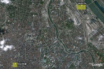
Figure 3: Example for visualizing prominent places in GoogleEarth. Yellow rectangles indicate the composition of cell-based positions for prominent places. Step-by-step, for each hour of day, the visiting frequencies of the prominent places are compared and the prominent place with the highest representation is selected for the sequence. In order to avoid toggling in the sequence at transition times of one prominent place to another, smoothed distributions are used for prominent place selections. i) being at home (at night/early morning), being at work (in the morning) ii) being somewhere else (in the afternoon/evening) and iii) being at home (in the evening/night) From this daily routine three classes of prominent places ‘home’, ‘work’ and ‘spare time’ are derived. Hence, the sequence which is to be compared to the computed sequence is {‘home’, ‘work’, ‘spare time’, ‘home’}. Experimental resultsvalidated by a 250 000 cell-based positioning data set obtained during a half year of permanent observation. Eleven of twelve home locations (92%) and nine of ten work locations (90%) have been found and correctly classified (Two volunteers moved their home during observation phase). Each volunteer has validated the result based on her provided cell-based positioning data with respect to the correctness of found and classified prominent places. All found prominent places are close to the real location. Geographical accuracy of the found places mainly depends on the cell-network distribution in the surrounding area and cannot be influenced by the used method. Hence, no quantitative validation about the localization quality was performed. Acknowledgements References[1] Ray, M. and Schrom-Feiertag, H.: Cell-based Finding and Classification of Prominent Places of Mobile Phone Users, In: Proceedings 4th International Symposium on Location Based Services & TeleCartography, November 2007 [2] Zhou C., Frankowski D., Ludford P., Shekhar S. and Terveen L.: Discovering Personally Meaningful Places: An Interactive Clustering Approach, In: ACM Transactions on Information Systems, Vol. 25, No.3, Article 12, July 2007 [3] Hightower J., Consolvo S., LaMarca A., Smith I. and Hughes J.: Learning and Recognizing the Places We Go, In: Proceedings of Ubicomp’05, 2005 [4] Ashbrook D. and Starner, T.: Using GPS to learn significant locations and predict movement across multiple users, In: Proceedings of Personal and Ubiquitous Computing 7, 2003 [5] Marmasse N. and Schmandt [6] Nurmi P. and Koolwaaij J.: Identifying meaningful locations, Submitted to: Conference on Mobile and Ubiquitous Systems: Networking and Services, 2006. [7] Laasonen K.: Clustering and prediction of mobile user routes from cellular data, In: Proceedings of the 9th European Conference on Principles and Practice of Knowledge Discovery in Databases (PKDD). Lecture Notes in Artificial Intelligence, vol. 3721. Springer-Verlag, 2005. |
|||||||||||||||
|
|||||||||||||||
|
Pages: 1 2


 (1 votes, average: 3.00 out of 5)


