Articles in the GNSS Category


Giovanni Dore, Mario Calamia
The integrity concept, intended as a continuous control of the information broadcast by the satellites, has been introduced by the Galileo system. Though the RAIM technique represents the first example of integrity monitoring, it has the characteristic to detect only local errors, at receiver level. The integrity monitoring applied by EGNOS, instead, could be seen as the forerunner of the Galileo one. Though there are many differences in the definition of integrity of the two system, the main aim is the same for both, that is to protect the user…

James L Farrell, John W lavrakas
Addressing GPS user problems
While GPS offers a ubiquitous, precise, and reliable positioning and timing service to much of the world, in many cases this service falls short. Anyone who has walked into a building with a GPS receiver actively displaying a location is aware of the immediate effect of the …

Phase centre is defined as a point (or a set of points) in space from which, when emitted, far-field phasefronts or, correspondingly, group-delay fronts are spherical or substantially spherical [1-2]. That is, the phase value is constant in a certain angular area of interest when measured with respect to the coordinate system whose origin is in the PC. However, PC is ambiguous for most of the real-life antennas and its position varies for…

GIOVE-A is a first Galileo test satellite launched on December 28, 2005. The satellite payload transmits two frequency signals at L1+E5 or L1+E6. There are 13 world wide located Galileo Experimental Sensor Stations (GESS) to track and monitor the GIOVE-A signals. High accuracy of GIOVE-A ephemeris or orbit, however, is essential for navigation applications. The paper presents a new method to deal with the precise orbit…

The idea of a software receiver is to sample the analog input signal as close to the antenna as possible and to implement the complete the data processing in software. Thus, the hardware is reduced to the minimum while all the digital signal processing is done by the mean of a microprocessor…

The development and deployment of the European Satellite Based Augmentation System EGNOS followed by the development of the Global Navigation Satellite System (GNSS) Galileo, that is currently under deployment, definitely represent the largest technological initiative promoted by the European Union so far. While designing and setting up its…

A GAGAN (GPS Aided Geo Augmented Navigation) is an Indian SBAS (Satellite Based Augmentation System) intended to provide accurate and reliable navigation information for all phases of flight over the Indian FIR (Flight Information Region) and in the adjoining areas applicable for safety-of-life operations meeting the performance requirements of ICAO. The implementation of the GAGAN program is being realized through the following two phases…

There are some countries trying to develop their own GNSS system. Is there any race? If yes, how appropriate and where would it lead to? Here are some views
“Well first of all there is the issue of robustness and putting all your eggs in one basket – that is one aspect and a major legitimate concern. The other, is a matter of national pride. In Europe there is a feeling that GPS dominates things…
Today, the civil positioning, navigation, and timing (PNT) community needs a clear and concise statement of PNT needs. This statement should incorporate all aspects of PNT services and all applications and modes of PNT use. With such a statement, providers of PNT technology and services will be better able to plan for, develop, and implement their PNT services. While I offer my thoughts on this need for the United States, the arguments…
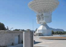
For interplanetary missions, the determination of S/C state vector (position and velocity) is required both for navigation purposes and science operations. The main error sources affecting S/C tracking data are the solar corona and the interplanetary plasma, which could be removed by using the multifrequency link technique between the probe and the ground station [1]. Once solar plasma noise has been removed…


 (5.00 out of 5)