Articles in the GIS Category

Landslide occurrence is one of the natural disasters which causes great damages annually all over the world and that is the reason, prediction and monitoring of landslides is of great concern. Landslide susceptibility determination relies largely on information which is provided by the landslide inventory maps. Therefore, precise land displacement determination can be regarded as one of the preliminary steps towards a more reliable landslide prediction.

A comparison between the seismicity and active faulting density maps indiactes that a good spatial correlation can be observed between these two parameters. It probably means that active faults are the main seismogenic sources responsible for generating earthqukes in this region. The good consistency observed between the seismogenic zoning map presented in this research and the results of the previous works indicates that the spatial analysis techniques can reliably be used for seismic hazard regionalization and identifying seismogenic hazardous zones in seismically active regions.

Ali Javidaneh, Mohammad A. Rajabi, Shima Rahmatizadeh
Ali Javidaneh
Graduate students of GIS
Department of Surveying and Geomatics Engineering,
College of Engineering,University of Tehran
Tehran, Iran
ajavidaneh@ut.ac.ir
Shima Rahmatizadeh
Graduate students of GIS
Department of Surveying and Geomatics Engineering,
College of Engineering, University of Tehran
Tehran, Iran
sh_rahmat@ yahoo.com
Mohammad A. Rajabi
Associate professor of GIS
Department of Surveying and Geomatics Engineering,
College of Engineering, University of Tehran
Tehran, Iran
marajabi@ut.ac.ir
KEYWORDS
Urban Growth, Cellular Automata, neighborhood …

The study areas are situated in the Arabian Gulf. -It is a shallow sea with its long axis oriented in NW-SE direction, and its average water depth is about 36m. The Evaporation and wind are the main driving forces for water circulation in the Arabian Gulf. Evaporation is stronger in winter due to high wind speed, than summer when the water surface temperature is higher. The overall circulation in the inner Arabian Gulf is cyclonic…

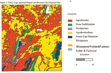
The present study aims at developing a generic automated methodology for addressing Multi-Objective Multi- Criteria Decision-Making problems. Scientific approach which make use of analytical modeling techniques are essential to suggest suitable changes in land use and to generate action plan for an area for land and water resource development. This problem can be cast into a multi-objective multicriteria decision-making problem…

Beneath our feet in the UK lies a vast labyrinth of millions of kilometres of buried pipes and cables, delivering key products and services essential to our social and economic well-being. These networks of buried assets need repair and maintenance, and the growing demands of the UK economy mean that in years to come the networks will continue to grow significantly, as will the amount of traffic on the streets under which many of these assets lie.
There are now more companies involved in digging holes across the UK than ever before. Latest estimates put this figure at around 4 million holes dug by utility companies annually, and this excludes any excavations made as part of construction projects and works away from the street. Every time a hole is dug it impacts on traffic and the local environment. Often, holes turn out to be ‘dry’ – inaccurate information means that assets thought to be there cannot be found.

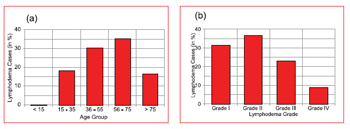
The disability problem due to Lmphatic Filariasis (LF) disease has been reported in 80 countries Ottesan EA (2000). Globally, the 1.1 billion people are exposed to risk of LF and the estimated LF affected population is 120 million Ottesan EA (2000), Michael E et al. (1996). Our recent estimation showed that there are 21 million diseased individuals in India alone Sabesan S et al. (2000) contributing approximately 40 per cent of global burden. A progressive lymphadema with increasing episodic attack adenolymphngistis (ADL) is the most important cause of physical suffering, permanent disability Pani SP and Lall R (1998) and the economic loss of the affected individuals and the community Ramaiah KD et al. (1998, 1999, 2000). Apart from these LF is also responsible for social problems including sexual disability and discomfort of marital life Dreyer G et al (1997).

The onset of the 21st century marked the beginning of the Asia-Paci?c era. This is the region where most of the world’s growth and economic development will occur over the next twenty years. The new millennium also signaled the birth of the urban era. Half of the world’s population now lives in cities, and that number is growing rapidly. In fact, the rate of urbanization in the Asia/Paci?c is alarming. The region currently has a population of 3.5 billion people; with that number expect to grow to 5 billion within the next 20 years. Most of that growth will occur in Asia’s cities.
This rapid urbanization presents staggering challenges for the region’s city governments. Up until now, most cities have not developed in a sustainable way. Economic development, land use planning, urban infrastructure, sewers, potable water systems, solid waste handling, and transportation systems are all inadequate to meet current needs let alone the rapid growth that lie ahead.

Universal lessons have emerged from Australian local governments using GIS for more than 25 years. This commonality of GIS experience rises above the significant variations in functions, statues, geographical coverage and population densities in Australian local government. These lessons are relevant to the skill development, data access, technology integration, and functional integration of GIS to any organisation managing the assorted demands upon a region, or locality.


 (5.00 out of 5)