| LBS | |
SAT-SURF: An innovative & flexible HW+SW platform to assist research
The integration of navigation and communication functionalities is one of the key elements exploited in new location-based systems and services |
|
GNSS technologies are progressively becoming one of the key elements in most of innovative wireless applications. Most location-based services and systems are in fact employing standalone GPS, GPS+EGNOS (or WAAS), Assisted-GPS and Differential GPS as core technologies. In order to support the fast diffusion of such technologies, and in order to be ready for the Galileo innovations, companies and academy need to invest at the R&D level as well as to train engineers, technicians and students on these subjects. For this purpose a novel platform has been designed and developed by the Navigation Signal Analysis and Simulation (NavSAS) group (research lab in cooperation with Politecnico di Torino and Istituto Superiore Mario Boella), focused on navigation & localization research topics.
SAT-SURF/ER: A brief description of the system
The new device is composed by SAT-SURF, a hardware box integrating NAV/COM capabilities, and SAT-SURFER, a software suite able to control and communicate with the hardware [1].
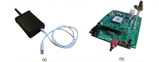
A graphical image of the hardware/software device is depicted in Fig.1.
Fig. 1: SAT-SURF : view of the case (a) and of the hardware board (b)
The SAT-SURF hardware includes components of the shelf, i.e. mass market GPS and GSM/GPRS modules. The innovation of this platform resides in its flexibility, since it has been designed not for a GPS module made by a single manufacturer, but it is has been conceived with a multiple footprint (i.e. pinout of a GPS module) of different GPS receivers. In detail, the current version of SAT-SURF can mount the following five GPS modules:
• uBlox ANTARIS 4 GPS module (DGPS compliant);
• uBlox 5 GPS module (OMA-SUPL Assisted GPS compliant);
• Falcom JP13-LP GPS module based on SiRFstarIII (low power consumption);
• Falcom JP15 GPS module based on SiRFstarIIx (DGPS compliant).
• SkyTraq Venus634LPx-T, a high-performance, low-power, precision timing GPS module.
SAT-SURF also allows to get the data from a remote receiver via TCP/IP connection. In particular SAT-SURF is capable of getting and logging data from all receivers supporting the Septentrio proprietary protocol called Septentrio Binary Format (SBF).
At time of writing, there is no Evaluation Kit (EVK) in the market allowing the same degree of freedom.
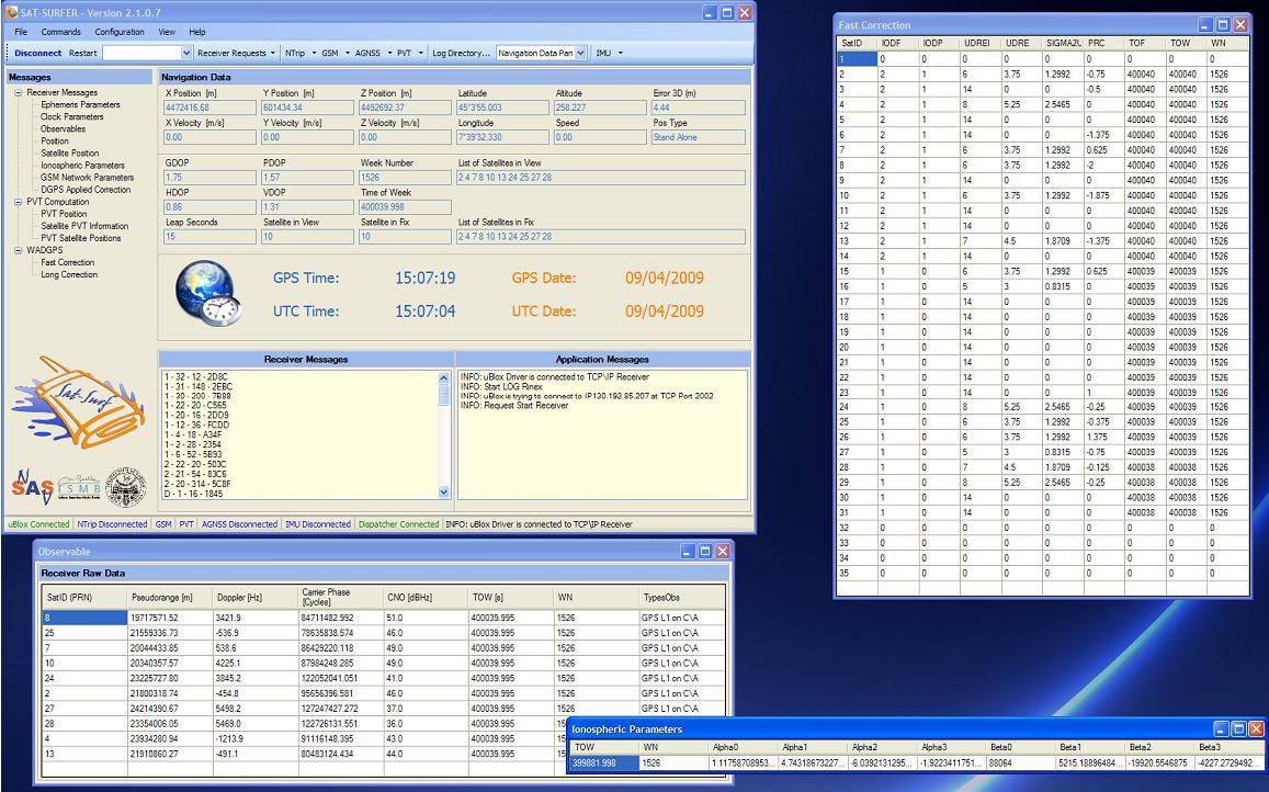
SAT-SURFER is the software suite running on standard PC that gets and processes data from SAT-SURF (Fig.2).
Fig. 2: Screenshot of SAT-SURFER Graphical Unit Interface
SAT-SURFER uses the proprietary protocols (not only NMEA) of GPS modules to get all the available receiver parameters and raw measurements, in addition to conventional positioning information. Such data are displayed in real time on a graphical user interface in order to easily monitor satellites, signals, receiver and user’s position. The same data are also logged with the related GPS time stamp and stored in different file formats (ASCII text files, MATLAB®, Microsoft Office Excel®, binary, RINEX 2/3, KML and NMEA) for easy post-processing and analysis purposes.
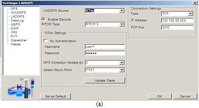
Such tool provides the possibility to have a common interface towards different GNSS receivers in order to perform measurements and detailed analysis on a common set of data. In particular considering the DGPS technique, it is possible to get the differential corrections as computed by the base receiver through different ways of connection (via COM, GPRS or TCP). Furthermore in case of TCP connection SAT-SURF is able to connect to a Networked Transport of RTCM via Internet Protocol (NTRIP) caster to obtain the required corrections and store all the parameters according to the RTCM standard.
SAT-SURF is equipped with a GSM module in order to provide AGPS functionalities as well. The connection to the Assistance Server can be set via TCP or via GPRS by using the GPRS modem integrated within SAT-SURF. All the communication sessions between the two terminals (Assistance Server of the Base Station and SAT-SURF) are based on OMA-SUPL protocol.
Recently SAT-SURFER allows the user to collect data from three different external Inertial Measurement Units (Microstrain 3DM-GX2, Microstrain 3DM-GX3, and Crossbow IMU.). An Inertial Unit is able to measure accelerations and angular rates of the system that is monitoring.
The supported IMUs implement three axes accelerometers, three axes gyroscopes and, only on the Microstrain models three axes magnetometers. Collected data are tagged using the IMU internal clock, synchronized with GPS (when it is required) and stored in MS Excel, Matlab or text files.
The core of the SAT-SURFER is realized in managed C++ based on .NET 2.0 and is able to control all the other software modules, including the data logging functionalities and several drivers for each GPS receiver, for the GSM modem and for other advanced functionalities (e.g. AGPS, NTRIP DGPS, SISNeT, etc.). Each driver is written in native C++ (unmanaged) allowing to a low level control of the connected hardware modules.
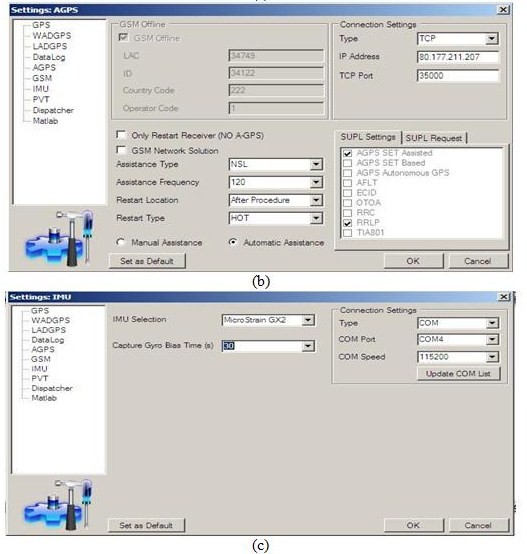
An example of different SAT-SURFER configurations and settings is reported in Fig.3.
Fig.3: An Overview of different settings and configurations of SAT-SURFER: Local Area Differential GPS (a), Assisted-GPS (b), Integration with external sensors: IMU (c).
SAT-SURF for research and educational purposes
The SAT-SURF and SAT-SURFER features discussed in previous Section offer a wide range of potential type of analysis and applications both for education and research purposes.
On an educational point of view some possible uses can be the following ones:
• practical training in the field of GNSS and communication technologies: in fact SAT-SURF and SAT-SURFER can be used in order to complement the necessary theoretical knowledge giving to the students a practical experience with real receivers;
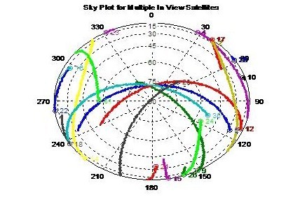
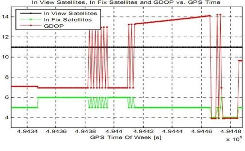
• analysis of the evolution of different signal and receiver parameters and observables (including number of satellite in view and used for the PVT computation, C/N0, Doppler frequency shift, carrier phase, GDOP, ephemeris parameters, ionospheric parameters, satellite positions) versus GPS time and in different environmental conditions (e.g. outdoor vs. light-indoor);
(a)
(b)
Fig.4:SAT_SURF as a tool aimed at GNSS education: sky plot of satellite in visibility (a), number of satellite in fix and in view respectively with the related value of GDOP (b)
• implementation and performance validation of PVT computation strategies using raw pseudorange measurements and reliable comparison of positioning performances.
At the same time, SAT-SURF represents a valid and effective instrument to be used by researchers which can give the possibility to store a huge amount of raw data and satellite parameters as well as to simplify the analysis in post-processing. At the time of writing SAT-SURF has been successfully exploited in several research experiments. The most remarkable ones are cited in the following part of the section:
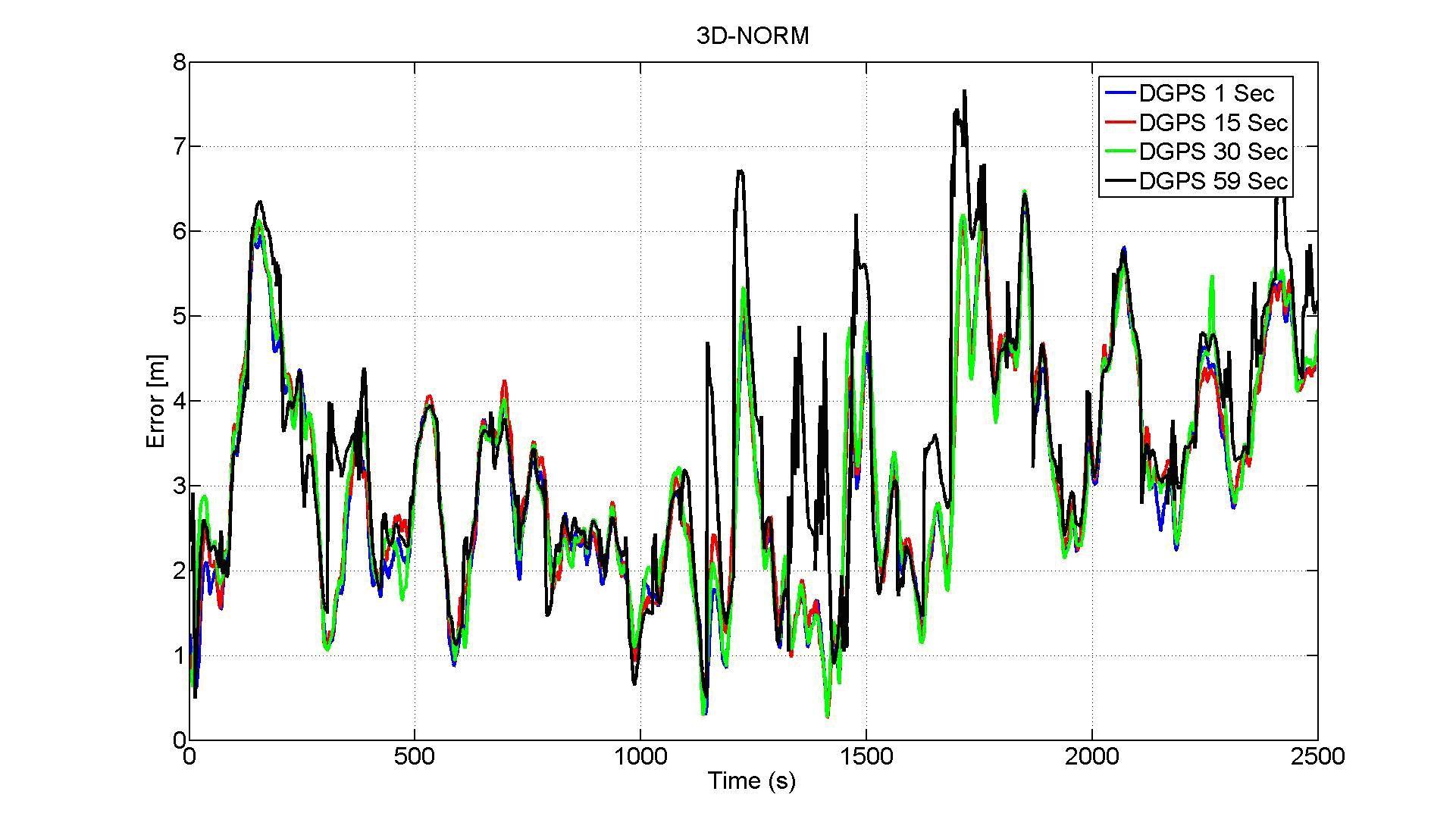
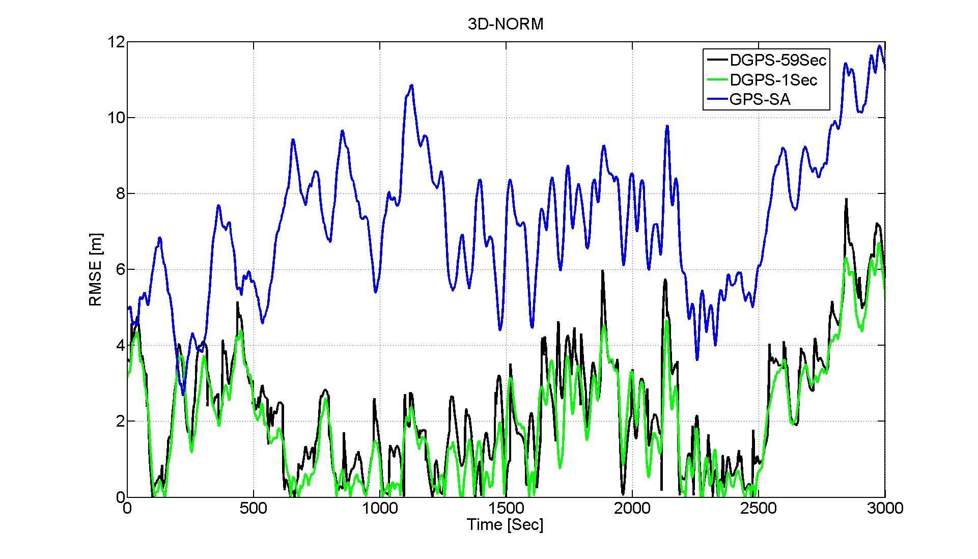
• Since there is not a clear-cut answer on the corrections update rate effect, the aforementioned device has been used to investigate how the time interval between a correction set and the following affects the positioning. Several tests both in static and dynamic mode have been run 2-4 hours long in different times of the day order to have exhaustive results [3]. For each of these trials four SAT-SURFs running in parallel were used and set to receive DGPS corrections with rates of 1, 15, 30 and 59 seconds. Results are plotted in Fig.5.
(a)
(b)
Fig.5: 3D-Error evaluation for different DGPS correction rate in Stationary Condition (a) and in a dynamic Open Sky scenario (b).
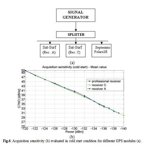
• One parameter that characterizes the performance of a GPS receiver is represented by the Acquisition Sensitivity that corresponds to the minimum power level a receiver is able to correctly identify a satellite signal [4]. By the combined use of SAT-SURF and a signal generator we have tested two mass-market GPS receivers and a professional one [5]. The final acquisition sensitivity values are then compared with respect to the parameters reported on their data sheets (Fig.6)
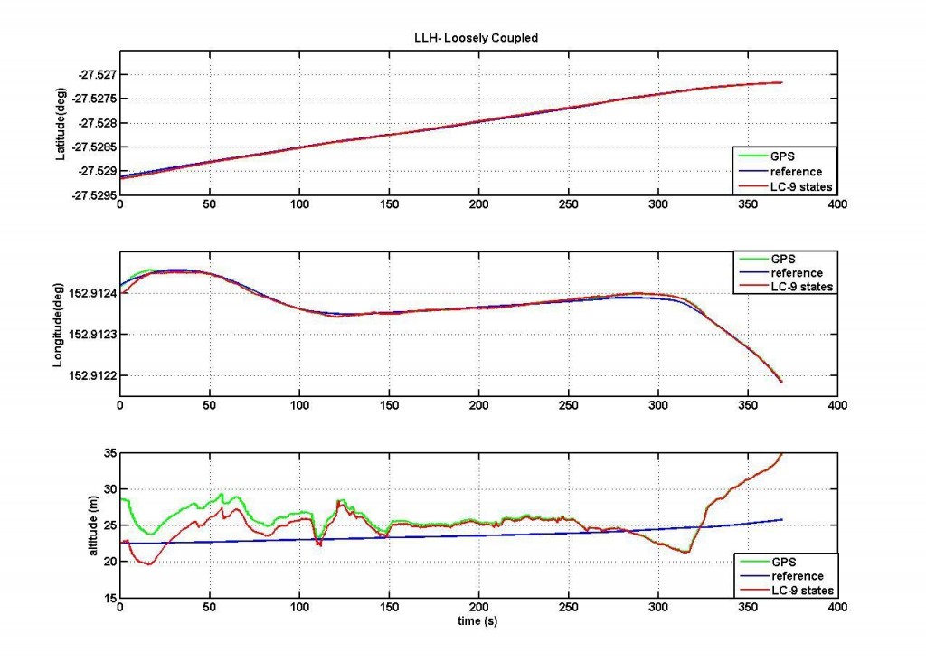
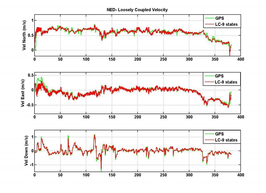
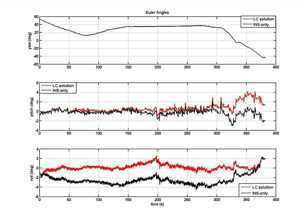
• The benefits of a GPS/INS integration are that the INS estimates be corrected by the GPS estimates and that the INS can provide position and angle updates at a quicker rate than GPS. For high dynamic vehicles such as missiles and aircraft, INS estimates can interpolate between GPS estimates. The two systems are complementary and are often employed together. Numerous approaches are possible for the integration of GPS and INS estimates to provide a combined navigation solution. Differences between the various approaches are based on the type of information that is shared between the individual systems. There are two main categories of integration approaches: loosely coupled (LC) and tightly coupled (TC). The first method uses GPS position and velocity measurements in a Kalman filter that models INS error dynamics. The second (?) approach uses GPS estimates of Pseudoranges and Doppler (determined by using satellite ephemeris data) and inertial estimates within a Kalman filter. By the use of SAT-SURF that collects raw IMU data synchronized with the GPS a loosely and tightly performance has been investigated. In Fig.7 an example of loosely coupled GPS/INS integration is shown [6].
(a)
(b)
(c)
Fig.7: Loosely Coupled performance: position (a), velocity (b) and Euler Angles (c).
• The integration of navigation and communication functionalities is one of the key elements exploited in new location-based systems and services. The Assisted-GNSS is a strategy based on such integration delivering through the COM channel assistance parameters [7]. The most recent architecture for the interchange of GPS assistance data is the so called OMA-SUPL [8] (Open Mobile Alliance – Secure User Plane Location). Specific tests in the field of Assisted-GPS proved the capabilities and flexibility of the tool highlighting interesting features in the use of aiding over embedded systems. For example we have run trials based on the architecture as depicted in Fig.8a where the SET is an embedded system (SAT-SURF) controlled by a SW tool (SAT-SURFER) that acts as SUPL agent and data logger [9]. The experiments have shown the benefits of the assistance in terms of TTFF (Time to First Fix) as well as of accuracy and sensitivity for an indoor scenario (Fig.8b)
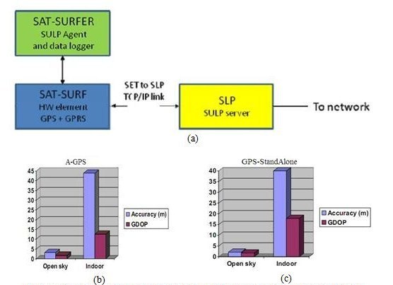
Fig.8: AGPS setup (a), Accuracy performance in case of an Open Sky and Indoor Scenario with and without Assistance (b), (c).
Conclusions
In this paper a novel NAV/COM platform for research and educational purposes has been introduced, presenting in detail the hardware (SAT-SURF) and the software (SAT-SURFER) feature and also showing some examples of applications. The examples described in the paper have stressed once again how the new device offers a high range of flexibility and how it can be a strong support for different research topics.
Reference
[1] Sat-Surf website: www.navsas.ismb.it/sat-surf.
[2] 3GPP Technical Specification TS 44.031.
[3] G.Falco, F. Dominici, G.Marucco, F.Dovis, “A study of DGPS performance in case of limited bandwidth availability”, Proceedings, ION GNSS 2008, Savannah International Convention Center, Savannah, Georgia, September 22-25, 2009.
[4] A.Mitelman, M. Reidevall, S.Strickland “Apples to Apples- Standardized Testing for High-Sensitivity Receivers”, GPS World (pp 26 – 33), January 2008.
[5] G.Falco, G.Marucco, A.Defina, F.Dovis, “A Comparative Sensitivity Analysis of GPS Receivers, ENC GNSS 2009, Napoli, Italy, May 3-6, 2009.
[6] G.Falco, G.Einecke, J.T.Malos, F.Dovis, “Performance analysis of Constrained Loosely Coupled GPS/INS Integration Solution”, INTERNATIONAL GLOBAL NAVIGATION SATELLITE SYSTEMS SOCIETY IGNSS SYMPOSIUM 2009, Surfers Paradise (QLD), Australia, December 1-3, 2009.
[7] F.van Diggelen, “A-GPS: Assisted GPS”, GNSS, and SBAS, Artech House Publishers, March 2009.
[8] UserPlane Location Protocol, OMA-TS-ULP-V1_0-20070122-C, V1.0, 22/01/2007.
[9] P.Mulassano, F.Dominici, A.Defina, “Assisted-GNSS performances on embedded systems solutions”, INTERNATIONAL GLOBAL NAVIGATION SATELLITE SYSTEMS SOCIETY IGNSS SYMPOSIUM 2009, Surfers Paradise (QLD), Australia, December 1-3, 2009.
 |
|
|||||
 |
|
|||||
 |
|
|||||
 |
|
My Coordinates |
EDITORIAL |
|
His Coordinates |
Paul Verhoef |
|
Mark your calendar |
NOVEMBER 2010 TO AUGUST 2011 |
|
News |
INDUSTRY | LBS | GPS | GIS | REMOTE SENSING | GALILEO UPDATE |



 (No Ratings Yet)


Leave your response!