| Surveying | |
SiReNT – Positioning Singapore for the future
|
||||||||||||||||||||||||||||||
|
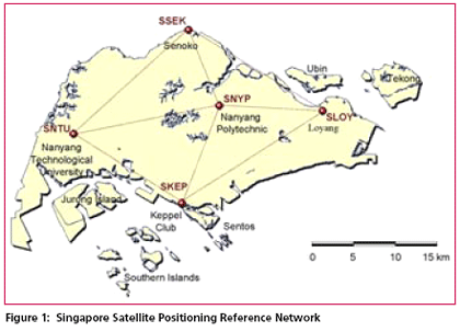
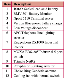
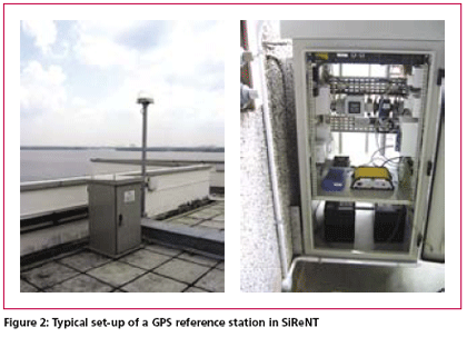
The Singapore Land Authority (SLA) will launch a new GPS reference station network in September 2006. The infrastructure known as the Singapore Satellite Positioning Reference Network (SiReNT) will replace the existing system, SIMRSN (Singapore Integrated Multiple Reference Station Network) which was developed in 2000 under a collaboration project between Nanyang Technological University (NTU), University of New South Wales (UNSW) and SLA. SiReNT is a nation-wide GPS reference station network infrastructure developed to support various positioning businesses and industries. SiReNT ensures a homogeneous geographical reference system for land surveying and mapping activities in Singapore. The system consists of 5 reference stations connected to a Data Control Centre (DCC). Figure 1 shows the location of the reference stations in SiReNT. SiReNT system adopts the leadingedge technology of Network-DGPS (Differential GPS) both for Real-Time Kinematic (RTK) and code-based DGPS technique. With SiReNT, a user needs only one receiver to carry out DGPS positioning. It supports both real-time and post-processing DGPS. In geodetic perspective, SiReNT serves as the national geodetic reference frame for surveying and positioning activities. It is regarded as the “Zero” order geodetic control of Singapore which is the reference frame for all mapping, positioning and surveying applications. SiReNT infrastructure is key component in the new SVY21 cadastral survey system, implemented in August 2004. Under the new survey system, surveyors use the SiReNT data for establishment of the Integrated Survey Network (ISN) control marks as the survey control in cadastral survey. This paper describes the SiReNT system, its components and the services provided. Network- DGPSOver the last 5 years, Network-DGPS technique has been extensively used for high accuracy positioning all over the world. Network-DGPS is an improvement over the conventional DGPS method. The principle of Network-DGPS is that a significant portion of ionospheric, troposheric and ephemeris errors are estimated over a region and this information is provided to rovers GPS receivers in the field. In carrier phase, the network technique is known as the Network-RTK. This technique has become very popular due to the short observation time needed and high accuracy obtained. SiReNT system supports the Network- DGPS technique. It uses the network software, GPSNet from Trimble Terrasat GmbH at the Data Control Centre which supports the Virtual Reference Station (VRS) technique. The GPSNet software performs continuous computation of the following parameters by analyzing double difference carrier observations: • Ionospheric errors • Tropospheric errors • Ephemeris errors • Carrier phase ambiguities for L1 and L2. Using these parameters GPSNet software will provide all GPS data and interpolate to match the position of the rover, which may be at any location within the reference station network. Matching the rover’s position provides a very short baseline, which reduces systematic errors for RTK considerably. SiReNT ConfigurationSiReNT network consists of 5 GPS reference stations located at the extreme corners of Singapore Island. This is to maximise the coverage area for the implementation of Network- DGPS. The GPS data is transmitted directly to the Data Control Centre (DCC) for processing, archival and real-time dissemination. System administrator will access the DCC via a remote access terminal. The network uses 256Kbps ADSL connection for communications link between reference stations to DCC. 56Kbps dial-up internet access is used as the back-up communications link. Each GPS reference station is equipped with a set of dual-frequency GPS receiver and a choke-ring antenna that operates continuously. The GPS equipment is installed on the roof-top of a building. The reference station also consists of other items such as batteries, temperature monitor, terminal server, cooling fans etc for communications and monitoring functions. All the equipments are housed in a weatherproof cabinet on the roof-top near the location of the antenna. The details of peripherals installed at the reference station are as follow: There are cooling fans in the equipment cabinet which is controlled by a thermal switch. The switch will be activated at 40ºC and deactivated at 30ºC. In the event of an AC power outage, the system will run on 2 batteries (100Ah) for approximately 65 hours. The temperature and power at the equipment cabinets are centrally monitored. In the event of abnormal condition, alert will be generated by the DCC and send via SMS to system administrator. The coordinates of the reference stations will also be monitored by the DCC. The monitoring processes designed to ensure the high reliability of the system. SiReNT ServicesSiReNT offers 3 standard services to meet various positioning needs and accuracy requirements: • Post-processing (PP) service • Real-time Kinematic (RTK) service • Differential GPS (DGPS) service SiReNT website (http://www.sirent. sla.gov.sg/) provides information about the network which includes the real-time status of reference stations and atmospheric conditions. It also allows Post-Processing (PP) service users to generate and download RINEX (Receiver INdependent EXchange) data. For RTK and DGPS services, SiReNT offers both single-base and network solution. A user has a choice to select the nearest reference station if he is working near to a reference station. Besides the standard services, SiReNT DGPS services can also be easily integrated into customised positioning products for other specialised applications such as land transportation, marine applications, structural monitoring, location base services etc. A helpdesk will be available to support users on technical issues related to SiReNT services. DGPS Data DisseminationThe data dissemination of SiReNT is supported by the iGate for post- processing applications and NTRIP for real-time applications. NTRIP (Networked Transport of RTCM via Internet Protocol) is an applicationlevel protocol used for streaming Global Navigation Satellite System (GNSS) data over the Internet. NTRIP is a generic, stateless protocol based on the Hypertext Transfer Protocol HTTP/1.1. The standard is meant to be an open none-proprietary protocol. Both the iGate and NTRIP are installed at the DCC. User needs a NTRIP Client to access the real-time services. For real-time applications of RTK and DGPS services, rover GPS receiver will be connected to SiReNT server via wireless Internet. Currently, rover users can subscribe to GPRS data services provided by any mobile provider. In real-time mode, SiReNT supports RTCM 2.1/ 2.3 and CMR format. Both formats are commonly adopted by major GPS equipment manufacturers. SiReNT users make use of the SiReNT website to access the post-process GPS data via iGate. RINEX version 2.1 and Compact RINEX can be generated from the website under the PP On-demand product. User is able to generate up to 12 months of data from SiReNT website. RINEX data will be available within one hour after the observation. Data older then 12 months will be archived. To access the old data, users need to put up a request to generate the data on a perrequest basis. In post-processing mode, SiReNT’s GPS data is distributed via SiReNT website in RINEX 2.1 or Compact RINEX (HATANAKA compression) version 1.0 format. The usage of SiReNT system will be captured in the website. Statement of account is updated daily and available to registered users via web access. Benefits of SiReNTSiReNT is a nation-wide GPS reference station network infrastructure. It provides high precision, real-time DGPS (Differential GPS) data and services. The system supports all types of GPS positioning modes and formats. It is flexible and easy for integration with minimum configuration. With SiReNT: • Many types of positioning applications that requires submetre accuracy are made possible; • Real-time high precision and high reliability surveying, mapping, navigation, tracking, applications are supported. |
||||||||||||||||||||||||||||||
|
||||||||||||||||||||||||||||||
|


 (2 votes, average: 3.00 out of 5)


