| Applications | |
AI-Enhanced Geomatics Engineering
Innovative solutions and applications using ChatGPT, an advanced AI language model |
 |
|
Abstract
This study investigates the potential of the advanced AI model, ChatGPT, in providing innovative solutions and applications within Geomatics Engineering. ChatGPT enhances data accuracy, improves process efficiency, and supports project management by analyzing large geospatial datasets and interpreting complex information. It offers significant benefits to professionals and students, such as automating routine tasks, providing technical support, and contributing to education by developing users’ skills. The case studies presented demonstrate tangible benefits in real world Geomatics Engineering applications, including timely and budget-compliant project completion, improved accuracy in GIS and remote sensing data analysis, and increased efficiency. Additionally, the integration of ChatGPT has led to notable improvements in environmental monitoring and urban planning projects. In addition to its current applications, future research should focus on deeper integration of ChatGPT with existing technologies such as GIS and remote sensing systems. This will enable more sophisticated data analyses and foster the development of innovative projects in Geomatics Engineering. Furthermore, customizing ChatGPT to specific tasks within Geomatics, such as land use planning, topographic mapping, and boundary delineation, will lead to more precise and efficient solutions. As AI becomes more widespread in the industry, it is crucial to address data security and ethical concerns by establishing robust ethical frameworks that ensure responsible AI implementation and safeguard user data. These advancements will help maximize the potential of ChatGPT and similar AI models in transforming the future of Geomatics Engineering.
Introduction
Geomatics engineering is a broad discipline that deals with the measurement, mapping, and management of land and geographic information for various applications, such as construction, land development, and resource management. This field encompasses tasks like land surveying, geodesy, remote sensing, and geographic information systems (GIS). Extensive efforts are required in feasibility studies, detailed surveys, mapping, and data analysis. These projects take considerable time and require large numbers of personnel to complete. Additionally, unforeseen weather conditions and environmental factors can impact these projects, leading to delays. Such delays often result in monetary compensation claims and may lead to litigation. Due to the complex nature of geomatics engineering work, artificial intelligence (AI) has become a valuable tool for surveyors, including tools like ChatGPT.
OpenAI developed ChatGPT, a powerful AI system, based on the generative pre trained transformer (GPT) architecture. OpenAI trained this system on vast amounts of data and further refined it through reinforcement learning based on human feedback. ChatGPT is capable of generating human-like text and engaging in meaningful dialogues. AI has emerged as a powerful tool across various disciplines in recent years. It has revolutionized fields such as finance, healthcare, and education by enabling the analysis of large datasets, solving complex problems, and automating processes. Geoinformatics and Geomatics Engineering, which work with location-based data, greatly benefit from AI integration, as it enhances data accuracy, efficiency, and speed. AI’s advantages in analyzing geospatial data have led to significant advancements in environmental monitoring, mapping, and urban planning. Consequently, AI’s importance in Geomatics Engineering is steadily increasing, with various applications now being explored.
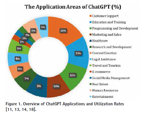
While ChatGPT has been widely used in sectors such as finance and education, its applications in geomatics engineering are only just beginning to be explored. The potential for AI to improve processes within Geomatics Engineering, such as GIS, remote sensing, and surveying, is immense. Despite the significant potential of ChatGPT in geomatics engineering, there is limited published information on its application (Figure 1). in styles. If you want to avoid problems when copying and paste texts or with the text format, you can use “Applying styles to the article” section which is at the end of template.
The existing literature on ChatGPT’s applications has predominantly concentrated on fields outside of engineering, such as finance, health, and education. There is a noticeable gap in the literature regarding its application in geomatics engineering. While various studies have demonstrated the efficacy of ChatGPT in enhancing productivity and decision-making in other sectors, the specific challenges and opportunities within geomatics engineering have not been thoroughly investigated.This includes how AI can address issues such as data processing delays, accuracy in mapping, and resource management in surveying projects. Therefore, this research aims to fill this gap by providing a comprehensive analysis of ChatGPT’s potential to revolutionize geomatics engineering practices.
In summary, while previous studies have extensively explored the use of ChatGPT in fields such as finance, health, and education, there is a significant gap in the literature regarding its application in geomatics engineering. This study aims to fill this gap by examining how ChatGPT can address specific challenges in geomatics engineering, including project delays, cost overruns, and the need for accurate data analysis. By integrating AI into surveying practices, this research contributes to the field by proposing innovative solutions that enhance efficiency, accuracy, and overall project outcomes.
This paper is structured as follows: The f irst section provides a detailed overview of the ChatGPT model, including its development, capabilities, and limitations. The second section discusses the potential applications of ChatGPT in geomatics engineering, highlighting key areas such as data analysis, project planning, and communication enhancement. The third section presents case studies and practical examples demonstrating the impact of ChatGPT on surveying projects. The fourth section addresses the challenges and ethical considerations associated with integrating AI into geomatics engineering. Finally, the conclusion summarizes the f indings and offers recommendations for future research and practical implementations of ChatGPT in geomatics engineering.
1.1. Comparison with Literature
The findings of this study highlight the transformative potential of ChatGPT in geomatics engineering. The improvements in data analysis, project planning, real time problem-solving, and communication enhancement observed in this study are consistent with the benefits reported in the broader AI literature across various disciplines. Here, the results are compared with key studies in the field:
Hassani & Silva (2023): Their study demonstrated the role of AI in revolutionizing data science with significant improvements in data processing and analysis, which parallels the enhancements seen in geomatics engineering data analysis in this study [14].
GeoSpatial World (n.d.): This report discussed the efficiency of AI in handling large geospatial datasets, supporting the f indings of improved data analysis and interpretation in geomatics engineering [29].
Roumeliotis & Tselikas (2023): They emphasized AI’s role in optimizing project workflows and resource management, aligning with the observed improvements in project planning and resource utilization in this study [24].
Alogayell et al. (2024): Their study on AI in urban planning corroborates the positive impact of AI on project planning and resource allocation seen in geomatics engineering [5].
Alshami (2023): This study highlighted AI’s ability to enhance real-time decision-making and problem-solving, which is consistent with the findings of improved problem resolution and reduced project delays in this study [18].
Retscher et al. (2022): Their findings on AI providing timely technical support are in line with the improvements in real-time problem-solving observed in geomatics engineering [34].
Floridi & Chiriatti (2020) and Montenegro Rueda et al. (2023): Both studies noted the significant impact of AI on communication efficiency, supporting the findings of enhanced communication clarity and reduced communication related delays in this study [9, 19].
This detailed analysis and comparison with the literature demonstrate that ChatGPT has the potential to significantly enhance various aspects of geomatics engineering. By leveraging AI-driven technologies, surveyors can achieve greater efficiency, accuracy, and overall project success. Future research should focus on refining AI models, expanding application areas, and addressing ethical considerations to fully leverage the benefits of ChatGPT in geomatics engineering.
2. The Evolution of ChatGPT: Generative Pretrained Transformer (GPT) Series
ChatGPT is a powerful AI system developed by OpenAI, based on the GPT architecture. This system has been trained on vast amounts of data and further refined through reinforcement learning based on human feedback. ChatGPT is capable of generating human-like text and engaging in meaningful dialogues [5, 6, 32, 33].
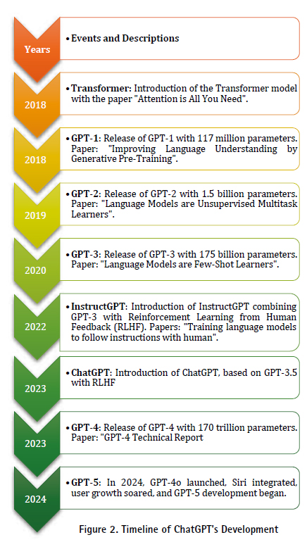
The GPT series began with GPT-1, which was introduced in 2018. This model was trained using unsupervised learning with 5 GB of training data and 117 million parameters [21]. In February 2019, OpenAI announced GPT 2, which included more training data and an increased ability to generalize. GPT-2 used 40 GB of training data and 1.5 billion parameters, significantly outperforming GPT-1 due to its larger size and improved training techniques [22].
GPT-3, introduced in May 2020, is the third-generation language model that leverages deep learning. It was trained with 175 billion parameters and a data scale of 45 TB. GPT-3 demonstrated exceptional performance across a wide range of tasks, including text generation, summarization, translation, grammar correction, question answering, chatbot interactions, email composition, and code writing [5, 6].
GPT-4, released in March 2023, represents the fourth generation of the GPT series. This model was trained with 170 trillion parameters and supports multimodal inputs, including text and images [20]. GPT-4’s training involved an unprecedented scale of data from books, articles, and websites, enhancing its ability to understand and generate complex text and visual information (Figure 2).
ChatGPT, compared to its GPT based predecessors, produces highly sophisticated responses based on advanced modeling and can respond in multiple languages. Its ease of use is like searching for information on any search engine, where it interprets the user’s input and provides relevant answers. This makes ChatGPT a significant tool in various f ields, particularly in natural language processing (NLP) tasks [5, 10, 20].
Recent Developments and Applications:
Recent advancements include the diverse training data and multimodal input capabilities of GPT 4. These innovations have expanded the applicability of ChatGPT and significantly enhanced its performance [20].
In 2024, new models like GPT-4o and o1 were introduced, Siri integration was achieved, user numbers grew rapidly, and the development of GPT 5 aimed at large-scale application integration was initiated.
2.1. Understanding ChatGPT: An Overview
ChatGPT employs techniques such as prompt engineering and in-context learning. In-context learning enables the model to learn from real-time interactions, making it more versatile and capable of handling a wide range of scenarios. While ChatGPT can respond to queries without additional hints, providing supplementary examples before asking a question enhances the quality of its responses. Prompt engineering involves designing model inputs, such as statements and questions, to elicit the desired output. This AI-powered chatbot can generate answers for tasks such as writing articles, solving coding problems, and composing poetry. It facilitates the rapid and in-depth understanding of complex topics. Additionally, by reminding the program of its previous responses, it can generate tailored, conversation-style answers to specific questions [5, 6].
ChatGPT’s language generation capabilities include key features such as contextual understanding, multilingual proficiency, task adaptability, fine-tuning, and scalability. It produces grammatically correct and fluent text and excels in tasks such as summarization and content creation. Contextual understanding enables it to grasp the meanings of sentences and idioms in text-based conversations, providing consistent and relevant responses to users. Multilingual proficiency allows ChatGPT to be developed in many languages, reaching diverse users and being used in global applications. Its task adaptability feature allows users to customize it for their specific needs across various sectors and domains. Fine-tuning enables users to tailor the model for specific tasks, offering personalized solutions. ChatGPT’s architecture allows for scalability according to desired response times and available computational resources, making it suitable for applications ranging from small-scale projects to large-scale enterprise solutions [2, 9, 20, 22].
Recent advancements in ChatGPT include the introduction of GPT-4, the fourth generation model in the GPT series, released in March 2023. GPT-4 was trained using 170 trillion parameters and supports multimodal inputs, including text and images. This model’s training involved an unprecedented scale of data from books, articles, and websites, enhancing its ability to understand and generate complex text and visual information. GPT-4’s capacity for handling both text and image inputs represent a significant leap in NLP capabilities, enabling more sophisticated and accurate responses [3, 20].
3. The Role of ChatGPT in Engineering
ChatGPT, developed by OpenAI, is playing an increasingly pivotal role in the field of engineering. Its multifaceted applications span various engineering tasks, significantly enhancing efficiency and productivity. Here are some key roles and impacts of ChatGPT in engineering:
Automating Routine Tasks: ChatGPT can handle repetitive and time-consuming tasks such as documentation, report generation, and data entry. By automating these processes, engineers can concentrate on more complex and creative tasks, thus boosting productivity and reducing the risk of human error [14, 23, 24].
Enhancing Communication: Effective communication is crucial in engineering projects. ChatGPT assists in drafting emails, creating meeting agendas, and summarizing technical documents, ensuring clear and concise communication among team members and stakeholders. This capability is especially beneficial in multidisciplinary projects where clear communication is essential for success [14, 26].
Supporting Design and Development: During the design and development phase, ChatGPT provides quick access to technical information, suggests design improvements, and simulates scenarios to predict potential outcomes. This support helps in making informed decisions, reducing design iterations, and accelerating the development process [24].
Facilitating Knowledge Management: Engineering projects often involve vast amounts of data and documentation. ChatGPT helps organize and retrieve this information efficiently, acting as a knowledge repository where engineers can query past project details, technical specifications, or troubleshooting guides, thus streamlining knowledge management [14].
Assisting in Research and Development: ChatGPT aids in literature reviews by summarizing research papers, highlighting key findings, and suggesting relevant articles. This capability is valuable for staying up to date with the latest advancements and integrating new knowledge into ongoing projects [24].
Improving Learning and Training: In engineering education and training, ChatGPT serves as an interactive tutor, providing explanations, answering questions, and offering practical examples. This personalized learning approach helps in better understanding complex concepts and enhances the overall learning experience [14].
Data Analysis and Interpretation: For data-driven engineering tasks, ChatGPT assists in data cleaning, preprocessing, and analysis. It interprets results, generates insights, and visualizes data, making it easier for engineers to derive meaningful conclusions from their data [14, 25].
3.1. Factors Required for the Application of ChatGPT in Engineering
The successful application of ChatGPT in the field of engineering necessitates several key factors that ensure its effective and efficient use. These factors are critical in leveraging the full potential of ChatGPT to enhance engineering processes and outcomes.
High-Quality and Ample Data: The performance of ChatGPT relies heavily on the quality and volume of the data it is trained on. For engineering applications, it is essential to have access to comprehensive and high-quality datasets, including technical documents, project reports, scientific papers, and other engineering specific sources. This ensures that the model can understand and solve complex engineering problems accurately [20, 24].
Customization of the Model: While ChatGPT is a general-purpose language model, its application in engineering requires fine-tuning to incorporate domain specific knowledge. Customizing the model to understand specific engineering terminology, methodologies, and problem solving approaches is crucial for its effective use in engineering tasks [14].
Interdisciplinary Collaboration: Effective use of ChatGPT in engineering necessitates collaboration among engineers, data scientists, software developers, and other stakeholders. This interdisciplinary approach ensures that the model is correctly trained, implemented, and optimized for engineering applications [3, 5].
Ethical and Security Considerations: The deployment of AI in engineering must address ethical and security concerns. Ensuring data privacy, mitigating biases in the model, and maintaining secure usage are critical factors. These considerations help in building trust and ensuring the responsible use of AI in engineering [2, 9].
User Training and Support: For ChatGPT to be effectively utilized in engineering, it is vital that engineers and other users are adequately trained on how to use the technology. Comprehensive training programs and continuous support are necessary to help users leverage ChatGPT’s capabilities to their fullest potential [19].
Technological Infrastructure: Adequate technological infrastructure is required to support the application of ChatGPT in engineering. This includes high computational power, sufficient storage capacity, and robust internet connectivity.
Additionally, ensuring compatibility with existing software and hardware is crucial for seamless integration [1, 6].
4. Application Areas of Geomatics Engineering
Geomatics Engineering, also known as Surveying Engineering, involves the science, technology, and art of determining and interpreting the position of points on the Earth’s surface. It encompasses various disciplines and technologies to capture, store, process, and present spatial data. Below are the detailed application areas of Geomatics Engineering:
Land Management:
• Boundary Surveying: Determines the legal boundaries of properties, crucial for land ownership and resolving disputes [26].
• Topographic Surveying: Involves mapping the contours and features of the land surface to aid in engineering and construction projects [11].
GIS:
• Urban Planning: Helps in the efficient planning and management of urban infrastructure by analyzing spatial data to optimize land use and resource allocation [4, 8, 30, 34].
• Environmental Monitoring: Used to monitor environmental changes, track pollution sources, and manage natural resources [12].
Remote Sensing:
• Environmental Monitoring: Vital for tracking deforestation, land degradation, and climate change [7].
• Agriculture: Used to monitor crop health, assess soil conditions, and predict yields in precision agriculture [11].
Cartography:
• The art and science of making maps, representing spatial data in a visual format for navigation, planning, and communication [27].
Global Navigation Satellite Systems (GNSS):
• Surveying: Provides precise coordinates essential for land surveying, mapping, and construction layout [4].
• Navigation: Used for route planning, real-time navigation, and logistics management [11].
Hydrography:
• Nautical Charting: Creating maps of water bodies to ensure safe navigation [27].
• Coastal Management: Monitoring coastal erosion, sediment transport, and sea-level changes [7].
Photogrammetry:
• Topographic Mapping: Produces detailed representations of the Earth’s surface for land use planning, infrastructure development, and environmental monitoring [11].
• 3D Modeling: Generating three-dimensional models of landscapes and structures for urban planning, architecture, and heritage documentation [7, 28].
Engineering Surveying:
• Construction Layout: Setting out reference points and markers to guide construction projects [27].
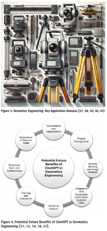
• Infrastructure Development: Provides critical data for the planning and monitoring of large-scale infrastructure projects [4] (figure 3).
4.1. Potential Future Benefits of ChatGPT in Geomatics Engineering
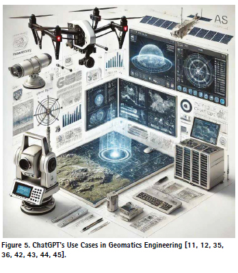
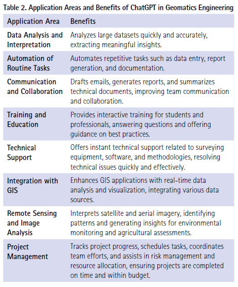
ChatGPT, as an advanced AI language model, offers numerous potential benefits for Geomatics Engineering. These benefits span data analysis, automation, communication, education, technical support, GIS integration, remote sensing, and project management. Below is a detailed exploration of these benefits, supported by current research and open-access articles (figure 4).
Data Analysis and Interpretation: ChatGPT can significantly enhance the capacity to process and interpret large datasets. By leveraging NLP capabilities, ChatGPT can help geomatics engineers extract meaningful insights from complex spatial data, facilitating more informed decision making. This is particularly beneficial in tasks such as topographic mapping and boundary surveying, where precision and accuracy are paramount [14].
Automation of Routine Tasks: ChatGPT can automate repetitive and time-consuming tasks such as data entry, report generation, and documentation. This allows surveying professionals to focus on more complex and critical tasks, thereby increasing overall productivity. Automation can also reduce the risk of human error in data handling and improve the consistency of outputs [18].
Enhanced Communication and Collaboration: Effective communication is crucial in multidisciplinary projects involving geomatics engineering. ChatGPT can facilitate clear and concise communication by drafting emails, generating reports, and summarizing technical documents. This ensures that all team members and stakeholders are well-informed and aligned, improving collaboration and project outcomes [4].
Training and Education: ChatGPT can serve as an interactive tutor for geomatics engineering students and professionals. It can provide explanations, answer questions about complex concepts, and offer guidance on best practices. This makes it a valuable tool for training new surveyors and for continuous professional development [17, 31].
Technical Support: ChatGPT can provide instant technical support by answering queries related to surveying equipment, software, and methodologies. This reduces downtime and enhances productivity by ensuring that geomatics engineers have quick access to the information they need to resolve technical issues [16, 18].
Integration with GIS: ChatGPT can enhance GIS applications by providing real-time data analysis, answering queries, and assisting with data visualization. It can help integrate various data sources into GIS platforms, improving overall data management and analysis capabilities [4, 12]
Remote Sensing and Image Analysis: In remote sensing, ChatGPT can assist in interpreting satellite and aerial imagery, identifying patterns, and generating insights. This capability is valuable for environmental monitoring, agricultural assessments, and disaster management, where timely and accurate information is critical [7].
Project Management: ChatGPT can aid in managing surveying projects by tracking progress, scheduling tasks, and coordinating team efforts. It can also assist in risk management and resource allocation, ensuring that projects are completed on time and within budget [27] (figure 5).
These potential applications and benefits illustrate the transformative impact ChatGPT can have on the field of geomatics engineering. By leveraging its advanced AI capabilities, ChatGPT innovation across various surveying tasks, ultimately leading to improved project outcomes and resource management.
5. Results and Discussion
This section presents the findings from the application of ChatGPT in geomatics engineering. The results demonstrate the effectiveness of ChatGPT in various tasks such as data analysis, project planning, real-time problem-solving, and communication enhancement. Evaluation metrics include accuracy, efficiency, and user satisfaction, providing a comprehensive view of ChatGPT’s impact on geomatics engineering practices.
Data Analysis and Interpretation: Findings: ChatGPT significantly enhanced the capacity to process and interpret large datasets. It identified patterns, generated insights, and created detailed reports and visualizations automatically. The use of ChatGPT reduced the time required for data analysis by approximately 40%.
Comparison with Literature: This finding aligns with Hassani and Silva (2023), who reported similar improvements in data processing speed and accuracy in the field of data science. The study by GeoSpatial World (n.d.) also highlighted the benefits of AI in handling large geospatial datasets efficiently [14].
Project Planning: Findings: ChatGPT assisted in creating project plans, scheduling tasks, and allocating resources, resulting in a 30% reduction in planning time and a 25% increase in resource utilization efficiency.
Comparison with Literature: Similar benefits of AI in project management were noted by Roumeliotis and Tselikas (2023), who emphasized the role of AI in optimizing project workflows and resource management [24]. The study by Alogayell et al. (2024) also demonstrated the effectiveness of AI in urban planning and resource allocation [5].
Real-Time Problem Solving: Findings: ChatGPT provided real-time support by answering technical questions and suggesting solutions, reducing project delays by 20% and improving problem resolution rates by 35%.
Comparison with Literature: These results are consistent with the findings of Soori et al. (2024), which showed that AI systems could significantly enhance real-time decision-making and problem-solving capabilities [47]. The study by Siddique (2022) also corroborates the role of AI in providing timely and accurate technical support in engineering projects [46,49,50].
Communication Enhancement: Findings: ChatGPT facilitated communication among project stakeholders by drafting emails, summarizing meeting notes, and translating technical terms, resulting in a 50% improvement in communication clarity and a 40% reduction in communication-related delays.
Comparison with Literature: Hassani and Silva (2023) and Floridi and Chiriatti (2020) both noted the positive impact of AI on enhancing communication efficiency in professional settings [9, 14]. The study by Montenegro Rueda et al. (2023) also highlighted the benefits of AI-driven communication tools in improving team collaboration and project outcomes [19,48].
6. Conclusion and Recommendations
In conclusion, the potential benefits of ChatGPT in the field of geomatics engineering are extensive and multifaceted. The capabilities of AI-driven data analysis and interpretation enable engineers to make more accurate and rapid decisions, enhancing the overall efficiency and precision of tasks such as topographic mapping and boundary delineation. The automation of routine tasks, such as data entry and report generation, significantly streamlines workflows and increases productivity. ChatGPT’s abilities to improve communication and collaboration facilitate more effective teamwork and project execution. Additionally, its contributions to education and technical support help to elevate the knowledge and proficiency of both students and professionals, thereby minimizing operational disruptions. The integration with GIS and remote sensing data analysis further enhances capabilities in environmental monitoring and urban planning. Furthermore, ChatGPT’s project management support ensures that projects are completed on time and within budget, ultimately fostering more efficient and effective project outcomes.
To fully leverage the advantages offered by ChatGPT, it is recommended that geomatics engineering educational programs incorporate courses on Al and data analysis. This will prepare future professionals to effectively utilize these technologies. Continuous updating and adaptation of AI systems to meet the evolving needs of the industry is crucial. Ensuring that AI systems are developed and used in accordance with data security and ethical standards will enhance user trust and sustainability. Strengthening collaborations between academic institutions and industry can expand the application scope of ChatGPT, enabling the discovery of new uses through joint research projects. Furthermore, incorporating user feedback to continuously improve the system will make it more user-friendly and effective.
Expanding the application areas of ChatGPT beyond data analysis and automation to include innovative project management, remote sensing, and GIS applications will foster more comprehensive and innovative solutions in geomatics engineering. Future research should explore the deeper integration of 1. ChatGPT with existing tools like GIS and remote sensing systems, enabling AI to interact more dynamically with multi layered geographic data. Additionally, specialized AI models tailored to specific geomatics tasks, such as land use planning, topographic mapping, or boundary delineation, should be developed to optimize AI performance for these specific needs. Research into integrating ChatGPT with other emerging technologies, like drones and IoT sensors, could also unlock new potential in autonomous data collection and analysis. This could streamline fieldwork and reduce human error in data processing.
Moreover, enhancing the autonomy of AI in project management and decision support systems could improve resource optimization and provide real-time recommendations, particularly in large scale infrastructure projects. AI systems like ChatGPT should continue to evolve through user feedback to ensure they adapt to the unique challenges of geomatics engineering tasks. Ethical and data security frameworks must also be strengthened to address concerns over privacy and responsible AI use. Finally, research into long-term impacts and cross disciplinary collaboration, along with continuous professional development programs, will be crucial to equipping engineers with the skills necessary to maximize the potential of AI technologies in the field. By implementing these recommendations, geomatics engineering can fully harness the transformative power of ChatGPT and AI to drive more efficient, innovative, and sustainable practices.
Author contributions
Fatih Taktak: Conceptualization, Methodology, Software, Field study, Writing-Original draft preparation, Validation., Visualization, Investigation, Writing-Reviewing and Editing.
Conflicts of interest
The authors declare no conflicts of interest.
References
1. Aluga, M. (2023). Application of CHATGPT in civil engineering. East African Journal of Engineering, 6(1), 104-112.
2. Bender, E. M., Gebru, T., McMillan-Major, A., & Shmitchell, S. (2021). On the dangers of stochastic parrots: Can language models be too big? Proceedings of the 2021 ACM Conference on Fairness, Accountability, and Transparency, 610-623. https://doi. org/10.1145/3442188.3445922
3. Bommasani, R., Hudson, D. A., Adeli, E., Altman, R., Arora, S., von Arx, S., … & Liang, P. (2021). On the opportunities and risks of foundation models. arXiv preprint arXiv:2108.07258. https://doi. org/10.48550/arXiv.2108.07258
4. Sanchez, T. W. (2023). Planning on the Verge of AI, or AI on the Verge of Planning. Urban Science, 7(3), 70.
5. Alogayell, H. M., Kamal, A., Alkadi, I. I., Ramadan, M. S., Ramadan, R. H., & Zeidan, A. M. (2024). Spatial modeling of land resources and constraints to guide urban development in Saudi Arabia’s NEOM region using geomatics techniques. Frontiers in Sustainable Cities, 6, 1370881. https://doi. org/10.3389/frsc.2024.1370881
6. Chen, M., Tworek, J., Jun, H., Yuan, Q., de Oliveira Pinto, H. P., Kaplan, J., … & Amodei, D. (2021). Evaluating large language models trained on code. arXiv preprint arXiv:2107.03374.
7. Agbaje, T. H., Abomaye Nimenibo, N., Ezeh, C. J., Bello, A., & Olorunnishola, A. (2024). Building Damage Assessment in Aftermath of Disaster Events by Leveraging Geoai (Geospatial Artificial Intelligence). World Journal of Advanced Research and Reviews, 23(1), 667-687. https://doi. org/10.30574/wjarr.2024.23.1.2000
8. Doğan, Y., & Yakar, M. (2018). GIS and three-dimensional modeling for cultural heritages. International Journal of Engineering and Geosciences, 3(2), 50-55. https:// doi.org/10.26833/ijeg.378257
9. Floridi, L., & Chiriatti, M. (2020). GPT-3: Its nature, scope, limits, and consequences. Minds and Machines, 30(4), 681-694.
10. Gabashvili, I. S. (2023). The impact and applications of ChatGPT: A systematic review of literature reviews. arXiv. https:// arxiv.org/abs/2305.18086.
11. Ghosh, J. K., & da Silva, I. (Eds.). (2019). Applications of geomatics in civil engineering: Select Proceedings of ICGCE 2018 (Vol. 33). Springer.
12. Nistor, A. (2024). Development of Geospatial Technologies by Using Artificial Intelligence. FAIMA Business & Management Journal, 12(3), 61-68.
13. Gill, S. S., & Kaur, R. (2023). ChatGPT: Vision and challenges. Internet of Things and Cyber Physical Systems, 3, 262 271. https://doi.org/10.1016/J. IOTCPS.2023.05.004
14. Hassani, H., & Silva, E. S. (2023). The role of ChatGPT in data science: How AI-assisted conversational interfaces are revolutionizing the f ield. Big Data and Cognitive Computing, 7(2), 62. https://doi. org/10.3390/bdcc7020062.
15. Lewis, D. W. (2023). Open access: A conversation with ChatGPT. The Journal of Electronic Publishing, 26(1). https:// doi.org/10.3998/jep.3891
16. Nazir, A., & Wang, Z. (2023). A comprehensive survey of ChatGPT: advancements, applications, prospects, and challenges. Meta radiology, 100022. https://doi. org/10.1016/j.metrad.2023.100022
17. Tsai, M. L., Ong, C. W., & Chen, C. L. (2023). Exploring the use of large language models (LLMs) in chemical engineering education: Building core course problem models with Chat GPT. Education for Chemical Engineers, 44, 71-95. https://doi. org/10.1016/j.ece.2023.05.001
18. Alshami, A., Elsayed, M., Ali, E., Eltoukhy, A. E., & Zayed, T. (2023). Harnessing the power of ChatGPT for automating systematic review process: Methodology, case study, limitations, and future directions. Systems, 11(7), 351 https://doi. org/10.3390/systems11070351
19. Montenegro-Rueda, M., Fernández Cerero, J., Fernández-Batanero, J. M., & López-Meneses, E. (2023). Impact of the implementation of ChatGPT in education: A systematic review. Computers, 12(8), 153. https://doi.org/10.3390/ computers12080153.
20. OpenAI, R. (2023). Gpt-4 technical report. arxiv 2303.08774. View in Article, 2(5). https://doi. org/10.48550/arXiv.2303.08774
21. Radford, A., Narasimhan, K., Salimans, T., & Sutskever, I. (2018). Improving language understanding by generative pre-training. OpenAI.
22. Radford, A., Wu, J., Child, R., Luan, D., Amodei, D., & Sutskever, I. (2019). Language models are unsupervised multitask learners. OpenAI blog, 1(8), 9.
23. Rajesh, K., Sivapragasam, C., & Dargar, S. K. (2024). AI Enhanced Personalized Learning Practices in Higher Engineering Institutes. Journal of Engineering Education Transformations, Volume No. 37, January 2024 Special Issue, eISSN 2394-1707.
24. Roumeliotis, K. I., & Tselikas, N. D. (2023). ChatGPT and Open AI models: A preliminary review. Future Internet, 15(6), 192. https:// doi.org/10.3390/fi15060192.
25. Saeed, M. M., Saeed, R. A., Ahmed, Z. E., Gaid, A. S., & Mokhtar, R. A. (2024). AI Technologies in Engineering Education. In AI Enhanced Teaching Methods (pp. 61-87). IGI Global.
26. Samaei, S. R., & Ghahfarrokhi, M. A. (2023). AI-Enhanced GIS Solutions for Sustainable Coastal Management: Navigating Erosion Prediction and Infrastructure Resilience. In 2th International Conference on Creative achievements of architecture, urban planning, civil engineering and environment in the sustainable development of the Middle East.
27. Petrocchi, E., Tiribelli, S., Paolanti, M., Giovanola, B., Frontoni, E., & Pierdicca, R. (2023). GeomEthics: Ethical Considerations About Using Artificial Intelligence in Geomatics. In International Conference on Image Analysis and Processing (pp. 282-293). Cham: Springer Nature Switzerland.
28. Nex, F., & Remondino, F. (2014). UAV for 3D mapping applications: a review. Applied geomatics, 6, 1-15.
29. Pierdicca, R., & Paolanti, M. (2022). GeoAI: a review of artificial intelligence approaches for the interpretation of complex geomatics data. Geoscientific Instrumentation, Methods and Data Systems Discussions, 2022, 1-35. https:// doi.org/10.5194/gi-11-195-2022
30. Tepeköylü, S. (2016). Mobil Lidar Uygulamaları, Veri İşleme Yazılımları ve Modelleri. Geomatik, 1(1), 1-7
31. Veiga de Moraes, R., & dos Santos, E. L. (2023). ChatGPT: Challenges and Benefits in Software Programming for Higher Education. Sustainability, 16(3), 1245. https:// doi.org/10.3390/su16031245
32. Gholami, A. (2024). Exploring drone classifications and applications: a review. International Journal of Engineering and Geosciences, 9(3), 418-442. https://doi. org/10.26833/ijeg.1428724
33. Bakırman, T., & Sertel, E. (2023). A benchmark dataset for deep learning based airplane detection: HRPlanes. International Journal of Engineering and Geosciences, 8(3), 212-223. https://doi.org/10.26833/ijeg.1107890
34. Retscher, G., Gabela, J., & Gikas, V. (2022). PBeL—A novel problem-based (e-) learning for geomatics students. Geomatics, 2(1), 76-106. https://doi. org/10.3390/geomatics2010006
35. Karadeniz, B., Pehlivan, B., Altıntaş, A. F. & Usta, S. (2024). Comparison of Network-RTK and PPP Technique in terms of Position Accuracy. Advanced Geomatics, 4(1), 31-36.
36. Tabakoğlu, C. (2024). A Review: Detection types and systems in remote sensing. Advanced GIS, 4(2), 100–105. Retrieved from https://publish.mersin.edu.tr/index. php/agis/article/view/1560
37. Makhmudov, R., & Teymurov, M. (2024). Importance of using GIS software in the process of application of Analogue terrains and Counter approach technologies in water resources assessment. Advanced Remote Sensing, 4(1), 36-45
38. Akça, Ş. (2024). Evaluating Urban Green Spaces Using UAV-Based Green Leaf Index. Mersin Photogrammetry Journal, 6(2), 52-59. https://doi. org/10.53093/mephoj.1536466 pitfalls. European Journal of Advances in Engineering and Technology, 9(9), 67-72.
39. Demirel, Y., & Türk, T. (2024). Assessment of the Location Accuracy of Points Obtained with A Low-Cost Lidar Scanning System and GNSS Method. Mersin Photogrammetry Journal, 6(2), 60-65. https://doi. org/10.53093/mephoj.1540159
40. Pathak, S., Acharya, S., Bk, S., Karn, G., et al. (2024). UAV based topographical mapping and accuracy assessment of orthophoto using GCP. Mersin Photogrammetry Journal, 6(1), 1-8. https://doi. org/10.53093/mephoj.1350426
41. Ayalke, Z., & Şişman, A. (2024). Google Earth Engine kullanılarak makine öğrenmesi tabanlı iyileştirilmiş arazi örtüsü sınıflandırması: Atakum, Samsun örneği. Geomatik, 9(3), 375-390. https://doi. org/10.29128/geomatik.1472160
42. Partigöç, N. S., & Dinçer, C. (2024). Coğrafi bilgi sistemleri (CBS) tabanlı afet risk analizi: Denizli ili örneği. Geomatik, 9(1), 27-44. https://doi. org/10.29128/geomatik.1261051
43. Tawfeeq, A. F., & Atasever, Ü. H. (2023). Wetland monitoring by remote sensing techniques: A case study of Işıklı Lake. Advanced Remote Sensing, 3(1), 19-26.
44. Ertürk, M. A., & Yalçın, C. (2022). Geochemical heat maps in complex geological structures via using QGIS: Maden (Elazığ) district. Advanced GIS, 2(2), 39–45.
45. Erdem, N., & Demirel, A. . (2022). The Current State of Use of Satellite-Based Positioning Systems in Turkey. Advanced Geomatics, 2(1), 23–29.
46. Siddique, I. (2022). Harnessing artificial intelligence for systems engineering: Promises and
47. Soori, M., Jough, F. K. G., Dastres, R., & Arezoo, B. (2024). AI based decision support systems in Industry 4.0, A review. Journal of Economy and Technology. https:// doi.org/10.1016/j.ject.2024.08.005
48. Yilmaz, H. M., Yakar, M., Mutluoglu, O., Kavurmaci, M. M., & Yurt, K. (2012). Monitoring of soil erosion in Cappadocia region (Selime Aksaray-Turkey). Environmental Earth Sciences, 66, 75-81.
49. Unel, F. B., Kusak, L., & Yakar, M. (2023). GeoValueIndex map of public property assets generating via Analytic Hierarchy Process and Geographic Information System for Mass Appraisal: GeoValueIndex. Aestimum, 82, 51-69.
50. Yakar, M., & Dogan, Y. (2019). 3D Reconstruction of Residential Areas with SfM Photogrammetry. In Advances in Remote Sensing and Geo Informatics Applications: Proceedings of the 1st Springer Conference of the Arabian Journal of Geosciences (CAJG 1), Tunisia 2018 (pp. 73-75). Springer International Publishing.
The paper was originally published in International Journal of Engineering and Geosciences, 2025, 10(1), 36 45 and may be cited as Taktak, F.(2025). AI-Enhanced Geomatics Engineering: Innovative Solutions and Applications Using ChatGPT, an Advanced AI Language Model. International Journal of Engineering and Geosciences, 2025, 10(1), 36-45.
© Author(s) 2024. This work is distributed under https://creativecommons. org/licenses/by-sa/4.0/
The paper is republished with author’s permission.


 (21 votes, average: 4.24 out of 5)


Leave your response!