| GIS | |
GIS
Japan model inspires India’s spatial policy for urban planning
The new National Spatial Policy envisions 20-year urban blueprints, regional planning blocks, and transit-led growth to curb haphazard expansion and boost liveability across Indian cities. The three tiers will have proper policy frameworks. Taking a leaf out of Japan’s urban planning and governance playbook, India has framed a National Spatial Policy (NSP) to plan new cities, redevelop older cities, and align state and city planning with economic growth and liveability.
The ministry of housing and urban affairs has framed the policy, which will develop 20-year vision documents for city planning and create structures from regional to national level for implementation of the framework in a cohesive manner. The need for the NSP stems from projections of urban population living in cities – which is likely to grow from 30 per cent to about 52 53 per cent in 20 years. The NSP proposes a three-tier system – creation of a National Spatial Coordination Council (which will have representatives of line ministries, PMO and Niti Aayog), a State Spatial Strategy which will have a state-level group and a regional planning block which will be governed by a regional planning body.
According to sources, the NSP has proposed around 50 regional planning blocks, anchored in million-plus city regions. The NSP will set 20-year goals, a national structure, corridor maps, climate risk principles, and investment priorities. Every regional plan will include economic vision and growth drivers, infrastructure plan, natural resource and environment plan and climate action plan. Every city will also have a mandatory plan.
Two major thrust areas are land use and the transport system. The policy proposes that all states should employ a transit f irst and rail-led growth at the core. This means making public transport like mass transit corridors, Metro, RRTS and railway the primary arteries of urbanisation while highways are regulated as freight and logistics corridors.
The policy also proposes employing the Japanese concept of ‘Kukaku Seiri’, a principle of reallocation of land. This is used for transformation of unplanned urbanised areas on the fringe of cities. In this, land is exchanged among the owners and is consolidated for each owner, whilst some of the land is reserved for public facilities.
So overall, a landowner may lose small portions of land but the net worth increases as the government develops facilities and the cost of land rises. “For the government it means a more planned city rather than growth of urban slums,” said the official. The NSP also proposes redeveloping existing cities through comprehensive upgrades of legacy infrastructure (water, sewerage, housing, power and transport systems). https:// infra.economictimes.indiatimes.com
Department of Posts signs MoU with ESRI India
The Department of Posts (DoP), has signed a Memorandum of Understanding (MoU) with ESRI India. Under this MoU, DoP will be able to use Esri India’s high resolution imagery and street basemaps for its DIGIPIN portal. The collaboration will also enable the integration of DIGIPIN with Esri India’s Living Atlas portal, thereby making it accessible to the larger GIS community. Further, ESRI India will provide technical support to the DoP for seamless integration of their services for DIGIPIN. www.pib.gov.in
Verra releases innovative digital soil mapping tool
Verra has published a digital soil mapping (DSM) tool – VT0014 Estimating organic carbon stocks using digital soil mapping, version 1.0 provides guidance for the development, calibration, and validation of data-driven modeling methods to estimate soil organic carbon (SOC) stocks in a spatially explicit manner, including model uncertainty estimations. Because the tool is based on robust, up-to-date science and novel technologies, such as remote sensing, it enables ALM projects to generate high integrity carbon credits. verra.org
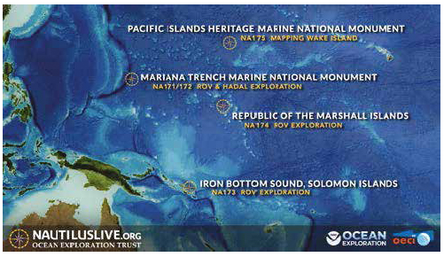
Exploring the maritime archaeology of Guadalcanal and Iron Bottom Sound
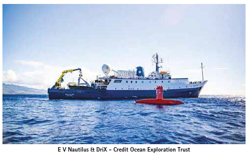
The Ocean Exploration Trust (OET)’s exploration vessel (E/V) Nautilus is underway on its third expedition of 2025 to conduct archaeological surveys of historically significant shipwrecks in the Iron Bottom Sound – the site of five famous naval battles, which were a turning point in the WWII Pacific theater. Led by OET President and famed explorer Dr. Robert Ballard, the 21-day expedition will utilize OET’s remotely operated vehicles (ROVs) in combination with the mapping capabilities of the University of New Hampshire’s uncrewed surface vessel (USV) DriX. This coordinated technology approach aboard E/V Nautilus demonstrates new efficiencies in archaeological ocean exploration supported by NOAA Ocean Exploration via the Ocean Exploration Cooperative Institute.
“I am looking forward to returning to Iron Bottom Sound, which I first explored in 1991 and 1992 when we discovered 12 lost Australian, Japanese, and American warships,” says Ballard. “This time we have a much more impressive array of undersea and surface vehicle systems and advanced acoustical and imaging systems needed to locate and document many of the warships and aircraft remaining to be discovered.” Located in the Solomon Islands, Iron Bottom Sound was the stage of five major naval battles between August and December 1942, which resulted in the loss of over 20,000 lives, 111 naval vessels, and 1,450 planes from the Allied forces and the Empire of Japan. These underwater maritime heritage sites now rest on the seafloor in a confined area offshore Honiara, less than 25 nautical miles wide and 40 nautical miles long. To date, only 30 of the military ships lost in this area have been located, with at least 21 remaining to be found within the deep waters of Iron Bottom Sound.
“NOAA Ocean Exploration’s mission is to explore the ocean for America’s benefit,” said Captain William Mowitt of the NOAA Corps, acting director of NOAA Ocean Exploration. “By pairing cutting-edge technologies like DriX with OET’s deep-diving ROVs, we have the potential to reshape our understanding of what lies in the deep ocean, from undiscovered shipwrecks to untapped resources.”
Exploration of Iron Bottom Sound has been underway for more than 30 years. Past missions aimed to find and identify wrecks, but further exploration is needed, focusing on sites that have not yet been imaged at a higher resolution. On this expedition, USV DriX will gather data for a more detailed map than ever before of the entire Iron Bottom Sound to identify exploration sites.
The team will then utilize the advanced camera systems of ROVs Hercules and Atalanta to conduct non-invasive archaeological surveys, assessing the condition of each wreck, its significance as an artificial reef, as well as identifying potential sources of marine pollution.
“It will be both humbling and very sobering to map out the extent of destruction that lies at the bottom of Iron Bottom Sound while recognizing the thousands of lives that were lost there and the significance of the sacrifices made,” says Dr. Larry Mayer, Director, Center for Coastal and Ocean Mapping at the University of New Hampshire.
Eighty years after the war, this expedition brings together archaeological experts from all former combatant nations — the United States, Japan, Australia, and New Zealand— as well as interdisciplinary experts worldwide through the Scientist Ashore program. In locating and exploring these historically significant sites, this expedition aims to honor those lost and keep alive the memory of sacrifices made during the Battles of Guadalcanal, as well as highlight the significance of this unique place globally.
“Iron Bottom Sound was the scene of f ive ferocious major night surface battles resulting in the loss of dozens of ships and thousands of men. Both sides fought with extreme courage and tenacity, although in the end the U.S. Navy and allies prevailed, at enormous cost,” said Naval History and Heritage Command Director Samuel J.
Cox, U.S. Navy rear admiral (retired). “These wrecks represent the last resting place of sailors who gave the last full measure of devotion in the service of their country. This expedition is an opportunity to remember the valor and sacrifice of those who turned the tide of war in favor of freedom, especially those who never returned home.”
The Maritime Archaeology of Guadalcanal expedition is supported by NOAA Ocean Exploration via the Ocean Exploration Cooperative Institute. This exploration is made possible by the expertise, support, and collaboration of many partners, including NOAA Ocean Exploration, U.S. Naval History and Heritage Command, Solomon Islands government, University of New Hampshire Center for Coastal and Ocean Mapping/Joint Hydrographic Center, and Japanese, Australian, and New Zealand colleagues.
The expedition will be streamed live on NautilusLive.org, a 24-hour platform that brings ocean exploration directly to viewers on shore. Telepresence technology allows viewers to engage with the team at sea, asking questions and receiving realtime behind-the-scenes updates via social media. Classrooms worldwide are invited to connect with the at-sea team via free educational Q&A interactions.
After this expedition, the OET 2025 field season will continue with exploration of the Republic of the Marshall Islands and Wake Atoll. OET’s 2025 expeditions will build ocean knowledge supporting international scientific and U.S. governmental priorities, particularly understanding the deep sea, sharing that knowledge with others, and contributing new discoveries and data to inform future resource management decisions. Through the open sharing of data collected during these expeditions, OET directly contributes to the US National Strategy for Ocean Mapping, Exploration, and Characterization, the Beyond the Blue: Illuminating the Pacific campaign, and other coordinated initiatives.
About the Ocean Exploration Trust
The Ocean Exploration Trust was founded in 2007 by Dr. Robert Ballard to explore the ocean, seeking out multidisciplinary discoveries while pushing the boundaries of STEAM education and technological innovation. Our international program is launched from aboard the Exploration Vessel (E/V) Nautilus, offering live exploration to participants on shore and the public via live video, audio, and data feeds. Learn more about Ocean Exploration Trust.
The 2025 E/V Nautilus expeditions are primarily sponsored by NOAA Ocean Exploration via the Ocean Exploration Cooperative Institute. OET program sponsors and partners for 2025 also include the Office of Naval Research, QPS, and the Phillip Stephenson Foundation.
https://nautiluslive.org/blog/2025/06/30/ exploring-maritime-archaeology guadalcanal-and-iron-bottom-sound


 (No Ratings Yet)


Leave your response!