| Positioning | |
Mass market receiver for static positioning
GPS receivers are able to be employed in the survey field as low cost sensors or for applications where it is necessary to have a good ratio between cost and benefits |
|
 |
|
||||
 |
|
||||
 |
|
||||
Nowadays, there are several low cost GPS receivers able to provide both pseudorange and carrier phase measurements in the L1band, that allow to have good real-time performances in outdoor condition. The present paper describes a set of dedicated tests in order to evaluate the positioning accuracy in static conditions.
The quality of the pseudorange and the carrier phase measurements let hope for interesting results. The use of such kind of receiver could be extended to a large number of professional applications, like engineering fields: survey, georeferencing, monitoring, cadastral mapping and cadastral road.
In this work, the receivers performance is verified considering a single frequency solution trying to fix the phase ambiguity, when possible. Different solutions are defined: code, float and fix solutions. In order to solve the phase ambiguities different methods are considered. Each test performed is statistically analyzed, highlighting the effects of different factors on precision and accuracy.
Goal of this research
The goal of this research is comparing two mass market low cost receivers in static positioning and perform a statistical analysis. The analyses are conducted considering post-processed solutions obtained with two commercial packages devoted to GNSS elaboration data.
Specific tests are carried out, changing the following parameters:
– length of baseline (<1 , ≈35 and ≈80 km)
– length of data sessions (10, 30 and 60 minutes)
The low cost receivers considered in this research were selected among chipsets able to provide as output pseudorange and carrier phase measurements. In particular the two commercial chipsets used in the tests are referred to “Receiver 1” and “Receiver 2” for motives of propriety.
Chipsets under test are hosted in the SAT-SURF hardware platform (one per receiver). The SAT-SURFER software is used to obtain simultaneous and homogeneous data logs. This aspect is described and explained in the following part.
The post-processing of the static sessions is done using two commercial software: Leica Geomatic Office (in the following LGO) made by Leica Geosystems and GRAFNAV made by Waypoint (in the following part called GRAF). LGO is a commercial software devoted to estimate, via post-processing, GPS solutions by means of a single-base analysis, adopting the forward approach. This software is able to work with both pseudorange and carrier phase based solutions.
GRAF is also a commercial software dedicated to define post processing solutions, adopting a differential and combined approach, but it is also able to realize a precise point positioning. GRAF achieves in providing a combined solution (forward and reverse), that means to improve the solution quality.
Tests
Each chipset, embedded in the SAT-SURF platform, is connected to a geodetic antenna NovAtel GPS-702 (IGS code NOV702_2.02). In order to simultaneously collect data with a geodetic receiver, a professional splitter is used. For each receiver several hours of data are collected; the resulting datasets are split in many short sessions: lasting 30, 10 and 5 minutes. The post-processing is performed considering different permanent master stations GPS (PMSG), in order to have baselines of different lengths.
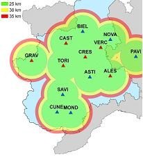
This experiment rely on the test GPS network in Piedmont (Italy) (Figure 1). It is a network composed by 15 permanent stations offering both real time services (by means of Virtual Reference Station, Multi-Reference Stations or Master Auxiliary real time products) and raw data.
Figure 1. GPS Test Network of Piedmont (Italy)
Three different PMSGs are selected from the list of the available stations, with the intent of having different distances. The pseudonym and the distances of each of the permanent stations used are reported in TABLE I.
SAT-SURF and SAT-SURFER
SAT-SURF and SAT-SURFER form a suite enabling an easy handling of GNSS data from different chipsets. The two components are respectively a hardware box integrating NAV/COM capabilities and a software application able to control and communicate with the hardware.
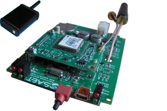
A graphical image of the hardware/software device is depicted in Figure 2.
Figure 2. A naked view of SAT-SURF (hardware)
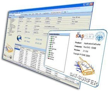
The SAT-SURF hardware includes components of the shelf, i.e. mass market GPS and GSM/GPRS modules. The innovation of this platform resides in its flexibility, since it has been designed not for a GPS module made by a single manufacturer, but it is has been conceived with a multiple footprint (i.e. pinout of a GPS module) of different GPS receivers. SAT-SURFER is the software suite running on standard PC that gets and processes data from SAT-SURF (Figure 3. ). SAT-SURFER also allows to get the data from a remote receiver via TCP/IP connection. In particular it is capable of getting and logging data from many receivers supporting their own proprietary protocols. In case a protocol is not foreseen a specific adapter can be written in order to expand tool capabilities. At time of writing, there is no Evaluation Kit (EVK) in the market allowing the same degree of freedom.
Figure 3. SAT-SURFER (software)
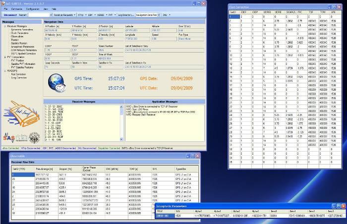
Figure 4. Screenshot of SAT-SURFER Graphical Unit Interface
SAT-SURFER is able to get all the available receiver parameters, data and raw measurements, in addition to conventional positioning information. Such data are displayed in real time on a graphical user interface in order to easily monitor satellites, signals, receiver and user’s position. The same data are also logged with the related GPS time stamp and stored in different file formats (ASCII text files, MATLAB®, Microsoft Office Excel®, binary, RINEX 2/3, KML and NMEA) for easy post-processing and analysis purposes.
Results
Each dataset is divided in several independent short datasets, in order to have a large number of solutions and to be able to realize the aforementioned statistical analyses. Each single dataset is elaborated as static, performing relative positioning with respect to the permanent stations reported in TABLE I. This is done adopting both software mentioned above.
Receiver 1
Considering the 10 minutes datasets, similar results are obtained, in terms of solution accuracy and number of fixes. This holds considering both packages and the different distances. The summary of float and fix solutions is shown in Table II.
This first analysis highlights two interesting results. The first one is that a fix solution is possible when a short dataset (10 minutes) is used, even if a long baseline is considered (80km). The second aspect is concerning the float solution accuracy. In the following diagrams, the residual values obtained comparing the estimated solution and the reference solution are displayed, allowing to appreciate the accuracy factor.
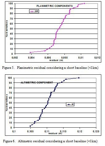
Residual values have a millimetric level in the horizontal and vertical components when a short baseline is considered (a offset is present on the vertical component), as shown in Figure 5. and Figure 6. In this case, float solutions are completely comparable with fix solutions, in term of accuracy.
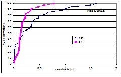
Considering longer baselines (35 or 80 km), the results are reported in Figure 7.
Figure 7. Plano-altimetric residual considering a long baseline
Similar results, in terms of accuracy, are obtained considering long baselines (35 and 80 km). For the 95% of observations, a sub-metrical accuracy level is achieved.
On the other hand, doing the same test with a shorter dataset, the results are completely different. Several 5 minutes datasets are considered and elaborated. The results are shown in Figure 8.
Figure 8. Plano-altimetric residual considering 5 minutes of data
Only one diagram is shown because a similar behaviour is observed considering different baselines. In this case, the final solution is obviously a code solution: a metrical accuracy is obtained.
In conclusion, it is possible to reach a cm-level accuracy, but at least a 10 minutes dataset has to be collected.
Receiver 2
In this analysis, same conditions (dataset length, distance from the permanent station and procedure of post-processing) are adopted.
First, the 30 minutes dataset is used to estimate the static positioning with the different PMSGs and both packages. Considering the shortest baseline (< 1 km), i.e. the best condition, the final solution is a float solution, however the accuracy of the coordinates has a submetrical level.
Several dataset of 10 minutes are considered, as done in the RECEIVER 1 case, but in this case the results are completely different. The summary of float and fix solutions is reported in Table III.
In this case, each solution is determined as float solution, with an average error in the baseline computation of 4-5 cm. The float solution determined with the “RECEIVER 2” have a completely different quality from the accuracy and precision point of view with respect to the float solution that was determined above.
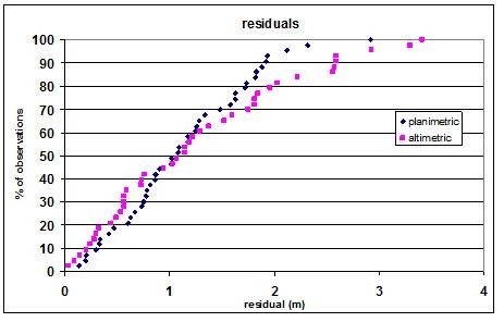
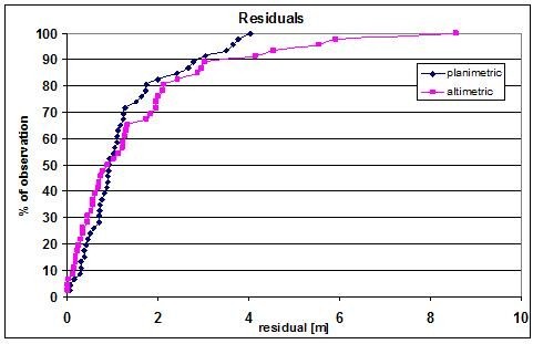
The planimetric and altimetric components have metrical residuals (Figure 9 a), less than 3 meters in 95% of observations.
Figure 9. Plano-altimetric residual considering a short baseline (<1km)
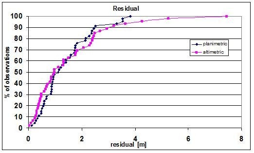
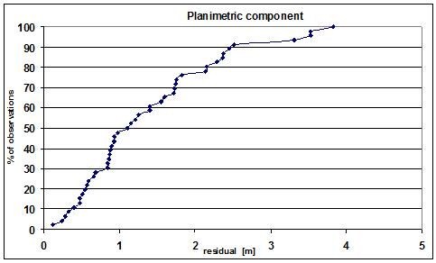
As above mentioned, the float solution is not synonymous of fair accuracy; considering the other permanent stations, the results lead to the same consideration. Similar results, in terms of accuracy, are obtained considering long baselines (35 and 80 km) too. The planimetric and altimetric residuals obtained with a different baseline length are shown in Figure 10.. In 50% of observations, a sub-metrical accuracy level is achieved.
Figure 10. Planimetric residual considering a long baseline
In this case the test with a longer dataset led to same accuracy of the middle dataset; this aspect has discouraged the Authors from doing tests with shorter lengths, being not necessary to verify the minimum length of datasets in order to obtain a fix solution.
Figure 11. Planimetric residual considering 30 minutes of data
In this test, the accuracy of the solution is similar to a pseudorange solution and it appears that the carrier phase is not even considered for a smoothed solution.
Conclusions
This research highlights and confirms some interesting aspects about mass market GPS receivers. First, there are differences between GPS receivers that have a important impact on accuracy and performance in static positioning.
Carrier phase contribute is fundamental in static positioning in order to obtain the best PVT solution (estimated in real time), but this is true only if the carrier phase measurement quality is good enough.
In general, the tests carried out highlight that centimetric accuracy in static positioning is possible even if long baselines are considered, but only using fairly long datasets (10 minutes) recorded with good chipsets.
The choice of algorithms employed for post-processing and phase ambiguity resolution is not fundamental in order to obtain a better accuracy in static positioning. Filtered and combined solutions lead to similar results.
Results allow to say that some mass market GPS receivers are able to be employed in the survey field as low cost sensors or for applications where it is necessary to have a good ratio between cost and benefits.
References
• PIRAS M, MARUCCO G., CHARQANE K.: STATISTICAL ANALYSIS OF DIFFERENT LOW COST GPS RECEIVERS FOR INDOOR AND OUTDOOR POSITIONING, IN OMNIPRESS, IEEE/PLANS 2010 PROCEEDINGS, PALM SPRINGS, CA-USA MAY 4-6 2010
• F. DOMINICI, P. MULASSANO, D. MARGARIA, K CHARQANE, SAT-SURF AND SAT-SURFER: NOVEL HARDWARE AND SOFTWARE PLATFORM FOR RESEARCH AND EDUCATION ON SATELLITE NAVIGATION, ENC GNSS 2009, NAPLES, ITALY, MAY 3-6, 2009.
• LEA-5T DATASHEET. AVAILABLE ON WWW.U-BLOX.COM
.
• SKYTRAQ VENUS 6. AVAILABLE ON HTTP://WWW.SKYTRAQ.COM.TW/.
• LEICA GEOMATIC OFFICE. AVAILABLE ON HTTP://WWW.LEICA-GEOSYSTEMS.COM .
• WAYPOINT GRAFNAV. AVAILABLE ON HTTP://WWW.NOVATEL.COM/PRODUCTS/WAYPOINT_GRAFNAV.HTM.
• HTTP://WWW.VERCELLI.POLITO.IT/CIVILI/GEOMATICA.HTM.
My Coordinates |
EDITORIAL |
|
Mark your calendar |
FEBRUARY 2011 TO NOVEMBER 2011 |
|
News |
INDUSTRY | LBS | GPS | GIS | REMOTE SENSING | GALILEO UPDATE |







 (2 votes, average: 1.50 out of 5)


Leave your response!