| Applications | |
3D Cadastral complexities in dense urban areas
Cities in developing countries are expanding rapidly and consuming every possible space available. The growth is not only in their physical expansion but also the increased urban population. The space consumption is again not only horizontal but also vertically underground and upwards covering the skyline of the city (Godard, 2004). Delhi, being a metro city and also the capital of India, is not an exception to this phenomenon. Property information systems based on 2D maps have served land administration and property management well for hundreds of years. However, most of the developed world (including Australia) and many developing countries now give ownership titles in buildings in three dimensions (3D) using the same 2D maps developed for traditional broad acre development on vacant land (CSDILA, 2012). The paper aims to study the multistakeholding urban area locations where 3D (infrastructural) developments are creating more and more complex land management situations for the authorities involved. We are presenting some cases in brief to highlight the different aspects of complexities while focusing on a particular case study of multiinfrastructure (utility) networks in one single area, where we have tried to understand the current administrative situation as well as spatial dimensions involved from Land Administration Domain Model context.
Land management and cadastral arrangementsCadastral systems in India were designed initially to earn revenue through collection of taxes on property. The cadastral systems support the legal ownership of the land, depiction of legal and topographical aspects including area and parcel boundaries. In India, the basic unit of the cadastral record is the land parcel, which is known as plot. The plots are registered in the name of the owner defining plot boundaries. Maintenance of land records with ownership; assessment of tax on the property and tax collection is the responsibility of district authorities. Each state is adopting their own methods of cadastral surveys, and emphasis is given to the legal aspects which are connected with rights. There is no concept of licensing and registration of cadastral surveyors in India. In fact, the government surveyors of state/center are carrying out all the cadastral surveys. Private sectors are now being involved for generating GIS and LIS for better management of land resources (Country Report, 2003). For several decades after Independence, Delhi has three municipalities: New Delhi Municipal Council (NDMC), Delhi Cantonment Board (DCB) and Municipal Corporation of Delhi (MCD) having their separate jurisdictions in Delhi. Recently in 2011-12, the Municipal Corporation of Delhi was divided into three parts: North, South and East Delhi Corporations (MCD Online, 2013; Directorate General Defence Estates, 2013; New Delhi Municipal Council, 2013). Municipal organizations including MCD, NDMC and DCB are executing agencies which provide basic civic amenities to the city like roads and waste management. These organizations have different jurisdictions covering the entire city. Only the Delhi Development Authority (DDA) is a land development authority. DDA takes the land from the Delhi Revenue Department or private parties whenever any land has to be developed or upgraded like a settlement. DDA has a role of planning (master plans, zonal plans) and initial development agency for the new areas while these executing agencies maintain these developed areas. There is no central registry of land in Delhi. Agricultural holdings are recorded, but urbanized land is not subject to any central registration system. In general, records of land held by governmental agencies are maintained by each individual agency, Delhi does have a longstanding system of deed registration. In accordance with the Registration Act, 1908 (Department of Land Records, 2013), the Delhi Government’s Registrar of Assurances is required to register most types of property transactions, although there are some exceptions. One important exemption is that changes of ownership through simple inheritance, and equitable mortgages need not be registered. Sale by power of attorney allows sales without registration, incentives to avoid fees and taxes (USAID, 2007; Rabenhorst, 2008). Current Tenure Characteristics in Delhi are (Rabenhorst, 2008):
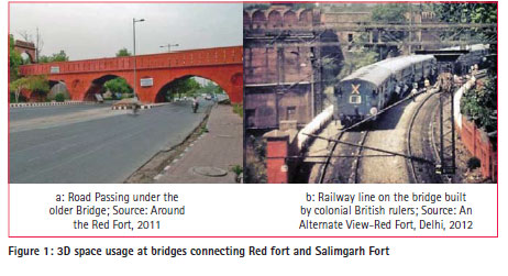
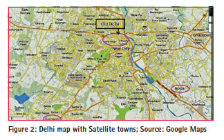
Delhi – A capital city alwaysIt has a long history of being the centre of political activities even before the 15th century. When Muslim invaders settled down in India after permanent invasion in early 15th century, they gradually settled down in Delhi (Krishna, V. B., 1980). At that time, the city was mostly limited to the northern part of Delhi on the banks of the river Yamuna. This part of today’s Delhi is called ‘Shahjahanabad’ or now popularly known as old city or the walled city. Some 3D usage examples from Mughal era and British times in the old Delhi city parts are still functional. One classic example is the Salimgarh Fort Bridge. Mughal Emperor Shahjahan built the Red fort in 1639 AD in Old Delhi. Close to this fort along the north-eastern part, there was an old fort called Salimgarh, built by Islam Shah Suri in 1546 AD. The river Yamuna once flowed between these two forts. The two forts are connected to each other by two masonry bridges (Comprehensive Conservation Management Plan, 2009). Today, the river does not flow here anymore. Now a road (Delhi Ring Road) passes under it with traffic in both directions. The second bridge was built by colonial British rulers on which they constructed a railway line from old Delhi railway station going towards the other side of Yamuna river (Figure 1). It is still functional and all types of trains pass through it (Around the Red Fort, 2011; An Alternate View-Red Fort, Delhi, 2012). After gaining independence in 1947, Delhi rapidly began taking shape of a metro city with many urban developments, including 3D spatial aspects in design, such as large multi-storey academic and office buildings (sometimes parlay above the road or other public spaces) and offices (Architecture of Delhi, 2013). In 1991, the Indian government adopted the liberalization concept for the nation’s economy (Panagariya, A., 2001; UNCTAD, 2012). Delhi still remained a union territory that was governed by the central government. All the civic bodies were functioning under the central government. By mid-1990s, it was decided to conduct elections for constituting a state-level government. However, certain important land management related bodies remained outside the scope of the Delhi government. This included Municipal Corporation of Delhi (MCD), New Delhi Municipal Council (NDMC), Delhi Cantonment Board (DCB) and Delhi Development Authority (DDA). By the start of the 21st century, Delhi had started growing rapidly in terms of population and infrastructure development and the amount of 3D solutions continuously increased. A big urban area/sub-city started taking shape in west Delhi just behind the international airport. This was targeted to provide housing to approximately 1 million middle class families (DDA, 2013; Architecture of Delhi, 2013). The Metro rail started operating in this decade and changed the entire landscape of Delhi by providing a mass transport system with high quality service. Its tracks were laid down on surface, above surface on the pillars and under surface through tunnels. A remarkable change in early 2000 was the fact that most of the plot-owning landlords started making basements while initiating constructions on the plot. The immediate satellite towns of Gurgaon, which because of Information Technology companies’ dominance is called cyber city, and Noida started feeling the pressure of demand for residential apartments and offices (Figure 2, Figure 5). Agricultural lands have been acquired by neighbouring provincial governments and sold to private developers. The builders have created or dug out the base for new high rise buildings in several hectares. Figure 2 shows Delhi with its utility networks of roads along with green spaces, natural drainages and settlement pockets. Metro train routes are also reaching satellite towns of Gurgaon in south, Noida and Ghaziabad in the east. This rapid expansion in Delhi and immediate neighbouring cities of Noida and Gurgaon came as a life-style changing shock to the traditionally agricultural communities of these cities. It was also a shock for the land administration of these cities that were not ready to deal with this rapidly changing land market and especially the 3D aspects hereof. The major player in the case of Gurgaon is Haryana Urban Development Authority (HUDA). The bureaucratic setup in the authority was still riddled with the inefficiency of paper work. Even after 20 years of this change, civic amenities are not up to the mark of a high value urban area. In Noida, the inefficiency of the authority together with political motives led to a large scale riot in 2009-2010-2011 when the government was accused of bias in following the land acquisition procedures (India Today, 2011; Indian Express, October 2009; Headlines India,2011; Indian Express, December 2009), The Hindu, 2009). Multi-stakeholding developments in urban scenarioThe 3D urban (infrastructure) development has affected many aspects of an average Delhi resident’s life. It has changed the way they travel to their office, the access to cooking gas, the water they receive in the flat, telephone and internet access. To provide these amenities, multiple government and private agencies have consumed the space of Delhi in different layers, above and below the Earth surface. The result is a situation in which the space (related to the same unit of surface land) is under control of different agencies with their user rights. In other words, many stakeholders in the form of civic amenity providing agencies become involved in the same place. This requires organizational level of coordination on a much higher scale than ever before because of the complexities of land management to lay down the service networks. Utility networks for different facilities are competing for the vertical and horizontal space. Different laws and directives need to be in place to ensure proper planning and construction of these networks without interfering with the operational functionality of other networks. To have proper laws and directives, there is a need to understand the spatial topology of these networks, their relation to surrounding land use and the mandates of the agencies responsible for them. Spatial dimensions involve understanding the space requirements in three dimensions and how the interaction of the networks takes place in the defined space. Land administration domain modelLand administration is a large field; the LADM international standard (ISO, 2012) is concerned with the representation of parties (natural and non-natural persons), spatial units (including survey and geometrical/ topological representations) and their relationships via RRRs; rights, restrictions and responsibilities (and the grouping into basic administrative units). In LADM, the basic administrative unit class serves the purpose of defining the bundle of RRR that apply to a given spatial unit, or a group of spatial units (Hespanha, 2012). In countries following the British common law tradition, this usually translates for the registration of a freehold right, together with optional appurtenances (minor rights) or encumbrances (restrictions). The LADM is capable of handling more than one type of registry, besides the commonly referred Land Registry (essentially registering private property RRR’s), for instance a Spatial Planning Government Portal, storing several types of public regulations and their associated spatial units. The LADM provides a reference model which will serve at least two important goals: (1) Avoiding reinventing, and reimplementing the same functionality, over and over again, but providing an extensible basis for the development, and refinement of efficient, and effective land administration system development, based on a Model Driven Architecture (MDA), and (2) Enabling involved parties, both within one country, and between different countries, to communicate, based on the shared vocabulary (that is, an ontology), implied by the model. Within the LADM, classical cadastral concepts as ‘parcel’ and ‘boundary’ (Lemmen et al, 2010; Thompson and van Oosterom, 2012) have been extended to be able to include spatial representations of overlapping tenures or claims and also multi-dimensional objects (3D and 2D/3D, combined with temporal dimensions). The spatial units may have a 3D representation, and a provision is made for a mixture of 2D and 3D spatial units to co-exist. A level is a collection of spatial units with a geometric or thematic coherence. The concept of level is related to the notion of ‘legal independence’ from Cadastre 2014. This allows for the flexible introduction of spatial data from different sources and accuracies, including utility networks, buildings and other 3D spatial units, such as mining claims, or construction works. The LADM introduces concepts such as ‘boundary face string’ (LA_BoundaryFaceString) and ‘boundary face’ (LA_BoundaryFace) and partially unbounded primitives. Spatial profiles and the different spatial representations are used to demonstrate the flexibility of spatial representations of this domain model. Three dimensional complexities in urban space – Case studies from Delhi and neighbourhoodTo show the various kinds of land complexities which involve different spatial dimensions, some cases from Delhi and its surroundings will be presented.
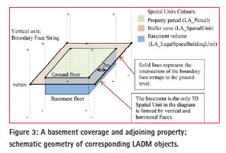
Case 1: Basement Coverage and Adjoining Property Due to building collapse incidents in congested areas of Chandni Mahal, Old Delhi and Uttam Nagar, West Delhi in 2011, the Municipal Corporation of Delhi (MCD) came up with a new regulation that makes it mandatory for builders constructing a basement to leave a buffer zone of 2 meter on all sides of the building being constructed. This has been done to make sure the adjoining buildings remain safe. According to MCD officials, the new rule is in accordance with Master Plan 2001(Page 159, Table 8 [4], Control for Building/Building within use premisesspecific premises residential plot-plotted housing, Foot Note No. IV) in which there is a clause that reads, “Basement up to ground floor level is required to leave 2 meter distance from adjoining property and is not counted towards Floor Area Ratio.” Spatial Dimensions 2D surface plot with rights granted to build underground basement structure which implies the 3rd dimension. The term “basement up to ground floor level” indicates a 3D space from the floor of the basement up to its ceiling which could be the ground floor level. Two meter distance to be left considers the geometrical connectivity of 2D surface plot to adjoining plots in 3rd spatial dimension also (complete vertical columns). LADM spatial unit context The upper face boundary is defined by ground floor coverage and the lower face boundary defined by the basement floor. The term “basement up to ground floor level” includes vertical boundary– faces to catch the 3rd dimension in its entirety. This case can also be modelled in its spatial and temporal dimensions considering a succession of different spatial units combining 2D and 3D geometric primitives. In a first instant, it defined a buffer zone as a building restriction, using an internal (closed) boundary face string, which lies 2 meter inside the property boundary face string. These are both implemented through 2D primitives, but represent unbounded vertical faces, forming thus an unbounded (above and below) ring around a space where building can occur. When construction is about to begin (in which new Legal Space Building Units, LA_ LegalSpaceBuildingUnit in LADM terminology, will be created), the basement volume can be defined by setting two horizontal boundary faces for the basement floor and the ground floor/basement ceiling. These two faces are 3D primitives which will touch the building outline boundary face string, thus forming liminal space (at the opposite side of the face string). When referring to the building outline, it must be kept in mind that the spatial unit delimits the legal space of the building and not necessarily its physical boundaries. Applying the operation as defined in ISO 19152 IS Annex B (ISO, 2012) will generate the vertical boundary faces required to close the volume representing the basement legal space (Figure 3). In the end, there are thus three spatial units:
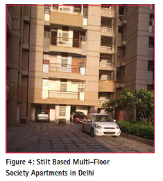
A. Property Parcel (2D representation, implying a 3D column); B. Buffer zone restriction (2D representation, implying a 3D column); C. Basement volume (3D representation). Case 2: high rise apartments made on stilt basis for cooperative group housing societies The following text is based on an actual conveyance deed of a flat owner in a stilt basis society building (Figure 4). The Registry/ Conveyance Deed of individual owner of a building unit (in a flat /apartment complex on stilts) with Delhi Development Authority (DDA) states that the vendor (DDA) accepts and reserves unto himself all mines and minerals of whatever nature lying in or under the said property. It gives full liberty together at all times for the vendor, its agents and workmen to enter upon all or any part of the property to search for, win, make merchantable and carry away the said mines and minerals. The mentioned elements could be under or upon the said property or any adjoining land of the vendor. The vendor can lay down the surface of all or any part of the said property and any buildings under or hereafter to be erected thereon making fair compensation to the purchaser for damage done unto him thereby, subject to the payment of land revenue or other imposition payable or which may become lawfully payable in respect of the said property and to all public rights or easement affecting the same.
Spatial dimensions The authority gives the rights to the individual flat owner, under the deed for which the owner pays registration fees, for the 2D surface or on the unit in a multi-floor residential building to live without paying rent for the property to the authority. This means the individual flat owner is allowed to hold the right to live and to own the unit in 3rd spatial dimension towards upwards. However, the owner needs to keep paying annual property tax to the municipal corporation. On the other hand, the Delhi Development Authority is making clear its rights on the mineral resources present in 3rd spatial dimension under the surface. Interestingly, it doesn’t mention anything about groundwater resource present in the same spatial dimension. In practice, the Cooperative Group Housing Society managements are allowed to do boring for groundwater extraction to provide drinking water to society residents.
LADM spatial unit context If the mineral resources are at ground level, its exploration, together with the required easements, could mean that any building would be at stake, and the required space returns to the state through an expropriation. This should be avoided by a (cheaper) surface geological mapping to clarify matters beforehand. If the mineral resources are below ground, the best course of action would be defining a 3D Parcel belonging to the State (which can then make a lease or concession). Apart from this 3D Parcel, there should be a 3D Parcel representing the upper unbounded space of the Housing Society. Also in this case there are at least three spatial units, as follows: A. Housing Society Property Parcel (3D upper half of infinite column); B. Individual building units (3D within Housing Society Property); C. Mining Property (3D lower half of infinite column). In addition, there should be some topologic constraints, in that the mining easements should intersect both the property parcel boundary and the mineral deposit.
Case 3: High groundwater disposal from the large construction sites (including basement) Knowing the subsurface components like soil composition in different vertical profiles, groundwater flows and volume or other minerals is important before initiating the construction. This can help to avoid the unforeseen problems in completing the construction process. As per Times of India, February 19, 2012, in a bid to conserve groundwater, the Noida Authority decided to initiate legal action against private developers wasting the precious resource during construction work. From now on, developers will have to submit affidavits assuring that they will minimize the wastage of groundwater before seeking permission for construction.
The decision came after a meeting of Noida Authority, State Pollution Control Board and Environment Pollution Control Authority (EPCA). Taking cognizance of a recent incident whereby a private developer had been blatantly wasting groundwater resources by pumping it out in a sewage drain for almost a year while digging for the construction of a mall in Sector 18 to make the terrain dry and suitable to construct the basement, Chairperson, EPCA directed the Authority to ensure that the work is halted. The Authority was also told to take appropriate action against the builder. The Authority has now served notices to all developers who have been carrying out massive construction work, directing them to submit affidavits and details of reusing the groundwater. While individuals who construct a floor or two for residential use can be spared, builders constructing high-rises must submit the affidavits. All cases of violations have been submitted to the Central Ground Water Commission. A related situation exists in case of cyber city Gurgaon, adjacent to Delhi, in the state of Haryana, where the Urban Development Authority cannot give license for construction to builders and developers until they submit an building/ construction request in which it becomes clear that they will not use the groundwater for construction work. As per July 16, 2012 Hindustan Times, the High court of Punjab and Haryana state had given this order while listening to the petition submitted by the Resident Welfare Associations of the neighbourhood. The associations had written in the petition that some big builders, while digging foundations for the large sites, were using the groundwater from the foundation for the construction and some were selling this groundwater through tankers to urban settlements in Delhi. On the other hand, due to falling groundwater levels, the borewell works done by resident societies in the neighbourhood were not getting any water.
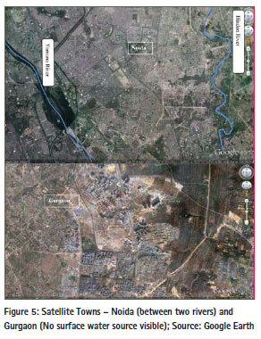
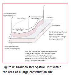
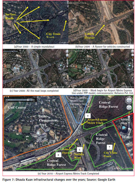
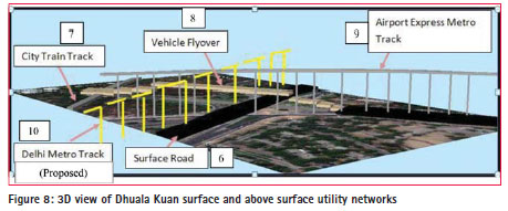
It is worth noting to consider the natural water availability in the cases of Noida and Gurgaon (Figure 5). The Noida extension construction areas fall between two rivers namely, Yamuna and Hindon. This means plenty of groundwater available at relatively low depth at least for the near future. This also means that developers in Noida can get easy water supply at cheap rates even in case of groundwater usage ban which keeps the construction costs lower. On the other hand, Gurgaon which is 15-20 km away from Yamuna has almost no surface water supply. About 80% water supply for different purposes is coming from groundwater extraction. Rainfall is less than 600 mm annually. This means developers find it economically attractive to use any groundwater they get while digging the foundation. Any kind of ban on groundwater usage is now going to increase the construction cost, although this will help to keep the groundwater stable in the shared aquifers. Spatial dimensions 2D surface plot with rights granted to build underground basement structure which implies the 3rd spatial dimension. The groundwater occurrence and related regulations increases the complexity of 3rd spatial dimension lateral extent. The geometrical connectivity of 2D surface plot in 3rd spatial dimension to adjoining and non-adjoining plots in the context of groundwater as a dynamic resource type needs to be considered. LADM Spatial Unit Context: In this case, a simple face boundary derived from boundary face strings (2D primitives) would not be sufficient. Boundaries in all spatial dimensions need to be made up of 3D primitives, which will help to build the adjoining boundary faces with 3D geometry and topology maintained as in geological models (Ghawana et al., 2010, 2012). The 3D geometry and topology will ensure correct volume calculations of groundwater for each stakeholder in case of a shared aquifer. Based on these 3D primitives, Upper face boundary can be defined by ground floor coverage. Lower face boundary defined by foundation floor. Vertical boundary– faces with their 3D geometry will help to catch the 3rd dimension in its entirety. In the case of groundwater, one important topological requirement would be the maintenance of surface (not horizontal, but along the flow) connectivity, especially if there is a groundwater stream flowing under the property ground surface. There could be defined a building restriction area at the surface for areas with high recharge potential, or a limitation in depth for the basement, due to a valuable deep aquifer which can still be recharged by sub-horizontal flows. This last restriction can be a simple 3D boundary face, which generates a layered representation within the property boundary face strings. The example in Figure 6 shows a private property spatial unit (the large construction site), represented by the set of boundary face strings named ‘VerticalFace1’ to 3. The groundwater spatial unit is derived then through the definition of top and bottom face strings (3D primitives), together with the set of vertical face strings (also 3D primitives) determined by the ‘as Polyhedron’ operation as presented in (Lemmen et. al, 2010). Case 4: Dhaula Kuan – Multiple (utility) networks and vertical space claimsDhaula Kuan is an interesting location from the perspective of land management complexities involved in actual situations. It is a major traffic intersection receiving traffic from all directions of Delhi. From land use point of view, it is interesting to see that it has a golf course for army personnel in Delhi Cantonment, a forest area called central ridge area, and it has two biggest five star hotels. Multiple (transport) networks are passing through this area: Surface Roads, vehicle flyover and loops, city train track and Airport Express Metro Link in addition to the utility networks for sewer, drinking water, electricity, etc. The situation is going to be more complex when the ordinary metro track construction will begin soon. It is not clear whether it will be above surface on pillars, on surface or underground, but under the third phase of Delhi Metro, a corridor will cross this path (Figure 7 and 8).
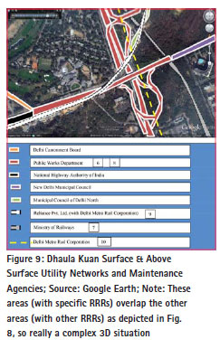
Administrative aspects At Dhaula Kuan, we find various agencies at work including NDMC towards Hotel Area. After MCD division, the area towards north side with the central ridge forest comes under the jurisdiction of North Delhi Municipal Corporation. Delhi Cantonment Board (DCB) takes care of the area inside Delhi Cantonment and that includes the golf course next to Dhaula Kuan Point. All the forest area, called Central Ridge, around this point comes under the forest department of Delhi government. There are many other executing agencies like Public Works Department (PWD), Delhi Metro Rail Corporation (DMRC), Land and Development Office of Indian government and Revenue Department of Delhi Government. PWD maintains the road infrastructure (surface road and flyover) up to the flyover end points on both sides and the loops. After the end of the flyover towards the western side, there is a traffic light which has one road going straight to the west (National Highway 8 ) and one taking a right turn, goes inside the Delhi Cantonment Area (General Carriappa Road). National Highway 8 after this traffic light comes under the National Highway Authority of India (NHAI) while the General Carriappa Road, after this traffic light, is maintained by DCB. On the eastern side of the flyover, after it ends, the roads are maintained by the NDMC. North Delhi Municipal Corporation is responsible for the maintenance of the ridge road going through the central ridge forest towards the north-eastern side. Under the Airport Metro express pillars, the ownership of the buffer zone of approximately 2 meter remains with governmental company DMRC. DMRC need not to take any permission for any kind of infrastructure work in this buffer zone from other executing agencies (Figure 7 and 8).
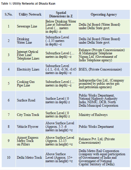
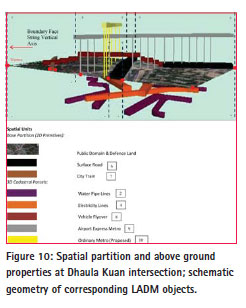
Spatial dimensions The complexity of spatial dimensions for different utility networks at Dhaula Kuan point is significant from the perspective of coordination between the various agencies involved. This coordination is important for the maintenance and thus for the smooth functioning of these networks. Table 1 lists the various utility networks which claims spatial space share in vertical dimensions also. It also mentions their approximate depth/height as well as the operating agencies which could be governmental, semi-autonomous governmental or private concessionaire agencies. Figure 9 shows the agencies having ownership/responsible for the maintenance of the utility networks which are on surface/above surface. LADM Spatial Unit Context The situation depicted in this case is obviously complex and involves a substantial number of different types of spatial units, which combine 2D, 3D and liminal representations. For the sake of simplicity, the following description is omitting the administrative subdivisions within the area, although LADM can be used for this purpose as well (Figure 10).
A first level of analysis concerns the delimitation of spatial units belonging to two basic forms of property: Public Domain and Private Property. This should form the basic partition of (2D) space, leaving no gaps or overlaps at this level, and is naturally best represented by boundary face strings following a 2D Topologic spatial profile (ISO TC211, 2011, Annex E). As already seen, these spatial units are in fact representing an unbounded vertical space, both above and below ground. In a second level of analysis, there should come all the spatial units which consider administrative servitudes and easements (also with 3D descriptions), whenever the ownership (public or private) differs from the one in the first level (the basic partition). This is the case with all the referred utility networks, where a specialized type of spatial units (LA_LegalSpaceUtilityNetwork) shall be considered. These should be represented by 3D spatial units, defining elongated prisms which carve out parts from the unbounded space defined by the spatial units in the basic level. Giving the traditional mandate of Land Registries, the situation should be carefully examined to see which spatial units are currently being registered, so as to consider possible modifications to the legal framework. This should consider particularly the spatial relationships between units in the public and private domains. The above description, considering just two levels of analysis, can be in fact more complex in reality, through the consideration of true 3D parcels representing a different ownership from the basic level (2D) parcels.In this case, it would be possible to consider a different level of easements (or administrative servitudes) which would be contained within these 3D parcels. As an example for the specific case above, the situation of a vehicle flyover forming a 3D Parcel (owned by a Public Party) could be considered where an easement for a Gas Pipe is included and is registered with a different owner. This would form a 3D spatial unit that should be contained within the volume of the 3D Parcel. In this example, it should also be considered administrative servitudes imposed in any basic level public property parcel (2D) which is crossed by the vehicle flyover. Conclusion and recommendationsDense urban spaces in developing countries are facing new challenges of land management on technical and institutional coordination level. Delhi and its immediate neighbourhood cities are going through a transformation process for land administration and their cadastral systems. There is an imperative need on land management related organisations and other stakeholders level to understand this rapidly changing scenario of land as a valuable commodity and also as a scarce resource. Cadastral systems need to be designed and supported from three dimensional spatial perspective and contributing for a continuously updated registration system(s). It is important to focus on determining the right type of data primitives so that to generate meaningful information in LADM Context or other generic spatial perspectives. As seen in these cases, underground and above ground structures need to keep a topological relationship with earth surface in between. In this paper, the focus has been kept on the support which the Spatial Unit package of LADM and its related modelling patterns can provide, in the context of particularly complex land administration cases in and around Delhi metropolis. A logical follow up, concerning a possible prototype implementation of a 3D cadastral system, should study the implications brought by considering the remaining packages of LADM (Legal and Administrative). A first version of such a system could be built upon the data already gathered for Case 4 at Dhaula Kuan. Future work also includes implementing the Spatial Unit model. For this an integrated TIN/TEN model is proposed, which represents the surface (2D) objects in a TIN and volumetric objects (3D) as TENs, which will be placed on top or below the TIN. It is also presumed that all 3D features are connected to the earth surface (Peninga, 2008). Such an integrated model can easily handle large data sets while maintaining 2D and 3D topological relationships. REFERENCESAn Alternate View-Red Fort, Delhi, 2012
Website: http://adatewithdelhi.wordpress.com/2012/05/04/an-alternate-view-red-fort-delhi/
Architecture of Delhi. 2013
Website: http://delhi-architecture.weebly.com/index.html; accessed in January 2013
Around the Red Fort, 2011
Website: http://sidharthbedi.com/2011/06/19/around-the-red-fort/
Blake, P. S., 1991; Minnesota; Shahjahanabad: The Soverign City in Mughal India, 1639 –
1739; Cambridge University Press,
Britannica Encyclopedia; Delhi, History, 2013
Website:http://www.britannica.com/EBchecked/topic/156501/Delhi/10839/History;accessed
in January 2013
Comprehensive Conservation Management Plan, 2009; Red Fort, Delhi; A collaborative
project of ASI and CRCI; Chapter 2: Site Description; Final March 2009.
Country Report, 2003; Based on the PCGIAP –CADASTRAL Template 2003; Dr. Prithvish
Nag, Survey of India.
CSDILA, 2012; T h e C e nt r e f o r Sp ati al D at a In f r a s tr uc t ur e s & La n d
A d min ist r at io n ; What is the Land and Property Information in 3D Project?;
Website:http://csdila.unimelb.edu.au/projects/3dwebsite/Research_aim.html; accessed in
August 2012
DDA, 2013; Urban Extension Projects – Dwarka, Delhi Development Authority,
Website: http://dda.org.in/planning/dwarka.htm; accessed in January 2013
Department of Land Records, 2013; Registration Act 1908
Website: http://dolr.nic.in/acts&rules/registrationact(1908).htm; accessed in January 2013
Department of Urban Development, 2013; Delhi Government; Schemes: Unauthorized
Colonies in Delhi
Website: http://ud.delhigovt.nic.in/unauthorized_colony.asp; accessed in January 2013
Directorate General Defence Estates, 2013
Website: http://www.dgde.gov.in/?q=cantonments/web/637; accessed in January 2013
Ghawana, T., Hespanha, J.P., Zevenbergen, J., and Oosterom, P. van, 2010;
Groundwater Management in Land Administration: A Spatio-temporal Perspective;
FIG Congress 2010, Australia
Ghawana, T., Zlatanova, S., 2012; Increasing significance of 3D topology for modelling of
urban structures; Geo Spatial World forum, April 2012 Amsterdam, The Netherlands
Global Development Research Private Limited, 2011; Slums of Delhi; Funded by Planning
Commission of India
Godard. J.P., 2004; Urban Underground Space and Benefits of going Underground; World
Tunnel Congress 2004 and 30th ITA General Assembly –Singapore
Headlinesindia, 09th May 2011; Opposition leaders arrested at Greater Noida
Website: http://headlinesindia.mapsofindia.com/state-news/uttar-pradesh/opposition-leadersarrested-at-greater-noida-82433.html; accessed in January 2013.
Hespanha, J.P., 2012; Development Methodology for an Integrated Legal Cadastre; Ph. D.
Dissertation, Technical University of Delft, The Netherlands, July 2012.
Hindustan Times, 16th July 2012; No fresh construction licences in Gurgaon: HC
Website: http://www.hindustantimes.com/India-news/Haryana/No-fresh-constructionlicences-in-Gurgaon-HC/Article1-890174.aspx; accessed in August 2012.
Indiatoday, 14th May 2011; Fuming Noida Farmers move court against Mayawati‟s Land
Policy
Website: http://indiatoday.intoday.in/story/fuming-noida-farmers-move-court-against-landpolicy-of-mayawati/1/138160.html; accessed in January 2013.
Indianexpress , 5th October 2009; Noida land acquisition: farmers up in arms
Website: http://www.indianexpress.com/news/noida-land-acquisition-turns-violent/554624;
accessed in January 2013.
Indianexpress , 16th December 2009; Noida land acquisition turns violent
Website: http://www.expressindia.com/latest-news/noida-land-acquisition-farmers-up-inarms/525003; accessed in January 2013.
ISO, 2012; ISO 19152:2012 ‘Geographic information — Land Administration Domain Model
(LADM), version 1 December 2012′.
Krishna V. B., 1980; MughalKaleen aur Adhunik Bharat [Mughal Period And Modern India]
Year 1526- Year 1947; Published by Arya Book Depot
Lahiri, N., 2011; Delhi‟s Capital Century (1911-2011): Understanding the Transformation of
the City; Colloquium Program for Agrarian Studies, Yale University, 4th Match 2011
Lemmen, C., Oosterom, P. van, Thompson, R., Hespanha, J., and Uitermark, H., 2010; The
Modelling of Spatial Units (Parcels) in the Land Administration Domain Model (LADM);
FIG Congress 2010, Sydney, Australia, 11-16 April 2010
MCD Online, 2013; Municipal Corporation of Delhi
Website: http://www.mcdonline.gov.in/; accessed in January 2013
Master Plan 2001(Page 159, Table 8 [4], Control for Building/Building within use premisesspecific premises residential plot-plotted housing, Foot Note No. IV)
New Delhi Municipal Council, 2013; New Delhi
Website: http://www.ndmc.gov.in/home/default.aspx; accessed in January 2013
Panagariya, A., 2001; India‟s Economic Reforms: What Has Been Accomplished? What
Remains to be Done? Economics and Development Resource Center Policy Brief No. 2;
Asian Development Bank
Peninga, F., 2008; Concepts of the integrated TIN/TEN approach, page 42, chapter 3; 3D
Topography-A Simplical Complex-based Solution in a Spatial DBMS, PhD Thesis, TU Delft.
Rabenhorst C. S., 2008; Towards a Title Registration System in Delhi: Why and How?;
World Bank Conference on Challenges for Land Policy and Administration, February 2008,
Washington, D.C.
Shahjahanabad Redevelopment Corporation, 2013; Delhi Government; Seven Cities of Delhi
Website: http://delhi.gov.in/wps/wcm/connect/doit_shahjahanabad/DoIT_Shahjahanabad
/Home/Monuments+in+Delhi/Seven+Cities+of+Delhi; accessed in January 2013
The Hindu, 11th May 2011; Situation tense in violence-hit areas of U.P.
Website: http://www.hindu.com/2011/05/11/stories/2011051160290300.htm; accessed in
January 2013.
Thompson R. and Peter van Oosterom, 2012; Validity of Mixed 2D and 3D Cadastral Parcels
in the Land Administration Domain Model. In: P. van Oosterom, R. Guo, L. Li, S. Ying, S.
Angsüsser (Eds.); Proceedings 3rd International Workshop 3D Cadastres: Developments and
Practices, October 2012, Shenzhen, pp. 325-342
Times of India, 19th February 2012; Authority warns of action against private builders;
Website: http://articles.timesofindia.indiatimes.com/2012-02-19/noida/31076867_1_
groundwater-resources-epca-builders; accessed in August 2012.
UNCTAD, 2012; Twenty years of India‟s Liberalization: Experiences and Lessons; United
Nations Conference on Trade and Development, United Nations Publication
USAID, 2007; A New Land Title Registration System for Delhi: Recommendations; The
Urban Institute, Washington D.C.
Website: http://en.wikipedia.org/wiki/File:1863_Dispatch_Atlas_Map_of_Delhi,_India_-
_Geographicus_-_Delhi-dispatch-1867.jpg; accessed in August 2012.
|




 (16 votes, average: 1.00 out of 5)


Leave your response!