| Navigation | |
Zheng He’s sailing to West Ocean
|
JIN DING, CHAOJIAN SHI ,ADAM WEINTRIT
|
||||
|
Zheng He’s Exploration of the Western Pacific Ocean and the Indian Ocean was an important event at the turning point of the world history. It was a golden opportunity for China to strengthen itself and make greater contributions to human beings. Unfortunately, to some extend, Zheng He’s magnificent feat in the history of navigation was later considered as a sheer waste of energy and money and a “failure policy”, and thus was put an end to. Zheng He’s trip, therefore, did not produce long-term effects. China still cut off itself from the out side world and stopped her exploration of ocean navigation, while Europeans, along the routes opened up by their expeditions, reached America, Africa and Asia and established colonies all over the world, which greatly promoted the capitalist development. In spite that the scale of Zheng He’s navigation far exceeded that of Columbus’s “Great Discovery” which followed some 80 years afterward, the former had much less effect on the progress of the world history. The reasons behind the suppression are complicated (Chen 2005, Lin 2003, Ma et al 2006). Confucian culture focusing on harmony and not conquering limited the achievements of collecting wealth and expanding territory. Agriculture oriented policy refrained exploration of nature and undervalued the scientific findings and technological innovations. The reasons may also include seeking the undeserved reputation of “emperorship of the whole world”, and spending too much money and resources without the expected effects. However, Zheng He’s sailing to West Ocean did mark an important waypoint on the passage of world navigation history. Never before in the world had there been any such adventure that was in such a scale, lasted for such a long time, had so many people under command, fared so far into the ocean, and had such advanced navigation technologies. It was suggested that the strength of Chinese naval exceeded the total strength of all the other countries of the world in that period of time (Wang 2005). Zheng He’s great voyages marked the age that the human civilization extended from land to ocean materialized an unprecedented miracle in the navigation history of China or even in the world. 1 ZHENG HE AND HIS TIME1.1 Historical background After the emperor Zhu Di took over power, council of ministers was in its course of recomposing. Confucian officer and eunuch were striking openly and secretly (Zhou 2006). He was going to gain support from the council of ministers where Confucian officer usually occupied the major part in the former time, but it were eunuchs who contributed a lot to Zhu Di’s ascending the throng. So he put eunuchs in a very important position. One of the duties of Chinese emperor was to at-tract “all under heaven” to be civilized in Confucian harmony. When foreign ambassadors came to the Chinese court, they “kowtowed” (the process of “kowtow” was to kneel three times and bow one’s head to the floor three times at each kneeling). In re-turn for tribute from other countries, the emperor sent gifts and special seals that confirmed their ruler’s authority. In fact, these foreign kings were officially made part of the Ming Dynasty. 1.2 About Zheng He Zheng He (also known as Cheng Ho) was born in Kunyang, Yunnan (present-day Jinning County, Yunnan Province) around 1371 AD. He was originally surnamed Ma, and was known as San Bao (Three Treasures) subsequently. Raised as a Muslim, Zheng He started to study the teachings of Islam at an early age. Both Zhang He’s father and grandfather had made the pilgrimage to Mecca, and so were quite familiar with distant lands. Listening to his father and grandfather’s stories, young Zheng He developed a consuming curiosity about the outside world. His father’s straight character and altruistic nature also made a lasting impression on the boy. Zheng He was captured by Ming Dynasty forces during their defeat of the remnants of the Yuan Dy-nasty in Yunnan, around 1381 AD. He was taken to Nanjing, where he was castrated and put into impe-rial service. He was then sent to Beiping (Beijing) to serve in the palace of Zhu Di, the Prince of Yan and the fourth son of the Ming Emperor. During Zheng He’s time in the palace, his brilliance and loyalty won him Zhu Di’s trust. As a result, the prince chose Zheng He to serve as his personal bodyguard during his quest to become emperor. It was during this period that Zheng He’s genius and leadership abilities became apparent. For four years, Zheng He went through fire and water at the side of Prince Zhu Di, accompanying him on countless campaigns and battles throughout China. Amassing victory after victory, Zheng He was instrumental in Zhu Di’s seizure of imperial power. Zhu Di often discussed and consulted matters of state with him, offering him numerous opportunities to learn about politics, military affairs, and strategy. After Zhu Di ascended the throne as the Yong Le Emperor, he promoted many of the military and civil officers who had supported him. Among them was the eunuch officer Zheng He. Zhu Di changed Zheng He’s surname from Ma to Zheng, and elevated him to the position of Grand Eunuch. Considering his extraordinary abilities and loyal service, Emperor Zhu Di deemed Zheng He the best choice for ocean voyage. Then, Zheng He was promoted to the third rank, acting as an envoy of the imperial court to foreign countries, thus beginning the greatest voyage in the world history. During his seven voyages, Zheng He fully displayed his talent and exhibited his extraordinary capabilities, proving himself to not only an outstanding military commander but also a superb diplomat and a statesman, with profound knowledge about Confucius-Mencius and about the world. From the first through the seventh ocean voyages, Zheng He devoted 28 years of his youth to the great cause of navigation. |
||||
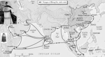
2 THE EXPEDITIONS2.1 Pre-sail preparations In 1402-1424, during the reign of Emperor Zhu Di, the imperial court ordered the building and modification of 25 batches of sea-faring boats, totalling 2860. They included four batches of what is known as “treasure ships”, totalling 343, the sea-faring vessels especially for the voyages to the western seas. There still remain seven docks for building ships at the ruins of Nanjing Long Jiang Shipyard and the Treasure Ship dockyard. Some historical records show that the sea-faring fleet under the command of Zheng He consisted of more than 200 vessels and 61-63 Treasure Ships. As the boats were built in different places, they varied in types, such as “FU” boats, “WU” boats, “GUANG” boats and “SHA” boats. The division of labour among the boats also varied according to different tasks they were assigned. There were large, medium and small sized treasure ships and boats for carrying water, soldiers, passengers, horses and foods. By “treasure ship”, it means exquisitely made boats for shipping official seals, official robes and all kinds of treasures to and from China. It also carried back rare animals, souvenirs and rare raw materials, spices, herbal medicines and crop seeds given to China as gifts from foreign countries. The king-size treasure ship measures 133.2 meters long; mid-size ones measure 111 meters long; and the smallest ones measure 60 meters long for carrying supplies. In Zheng He’s fleet, there were also eight-scull boats, which measures about 24 meters long, with two masts. It used masts in tailwind and when there was no wind, it used sculls. 2.1 Pre-sail preparations From 1405 to 1433, Zheng He made 7 voyages down to the Western Ocean. In order to avail the tailwind of the Northeast monsoon, Zheng He defied fatigue and completed preparations in less than one month and set sail from Liujia Port of Taicang. The second voyage, Zheng He visited Champa, Siam (Thailand), Java, Malacca, Nanwuli, Ceylon (Sri Lanka), Kayal (on the east shore of the southern end of the Indian Peninsula), Cochin and Calicut. By the time of the third expedition, 1409 to 1411, Zheng He had established a settled program. The fleet used Malacca as its forward base and there the fleet was divided into squadrons that sailed independently to separate destinations. The mission of Zheng He’s firth voyage was to escort envoys of 19 countries home and to procure all kinds of rare animals and spices from the Arabian Peninsula and East Africa. Zheng He was order to go on the sixth voyage to escort the envoys of 16 countries include Mogadishu and Brawa in East Africa home. In order to sail directly to the eastern coasts of Africa, Zheng He used stellar diagrams to measure the height of the stars to position the fleet. Menzies (2003) suggested that the fleet had not merely rounded the Cape of Good Hope and traversed the Atlantic, they had been gone to explore Antarctica and the Arctic, North and South America, and had crossed the Pacific to Australia. On the last voyage, when the fleet, carrying with rare animals and native produce, were sailing toward Calicut, Zheng He died of illness. According to the sea-faring tradition, he was buried at sea. Figure 1 and Table 1 show some more information about the voyages. Figure 1. Map of Ming China and Zheng He’s voyages
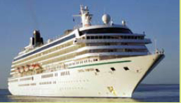
3 THE TECHNOLOGYVarious advanced technologies of the time were employed by Zheng He and his fleet to make the great feat. He successfully inherited the practice of former navigators in Chinese history and assimilated their ocean-going knowledge. He selected excellent sailors, made thorough preparations and built various types of seaworthy ships equipped with well-designed devices such as stabilization boards, watertight compartments, precise compass, and star boards. Based on the knowledge of his predecessors and the sea-going practice of his own, he prepared scientific navigation charts, which are of great value in history. He inherited and innovated the Chinese tradition of navigation through celestial observation. By inventing the technique of star board measurement for determining the height of celestial bodies and thus positioning, he elevated the navigation technology to a new level. He also had studied the general patterns of monsoon in the in the Chinese sea area, Indian Ocean and Arabian Sea and made effective use of these studies in his trip. The following subsections are contributed to part of the technologies employed by Zheng He and his fleet. 3.1 Ship building China has a long history of building ships. The general design featured vertical sails, with neither horizontal sails nor fastening ropes. The sails were usually made of cloth or woven by bamboo chips stiffened by bamboo poles for wind-efficiency. With centuries of experience in building ship to sail storm-tossed oceans, the Chinese marine engineers had evolved a robust frame built in sections. Each section was contained by watertight bulkheads at either end, resembling the internal partitions of a bamboo. The watertight sections were bolted together with brass pins weighing several kilograms. Three layers of hardwood were nailed to a teak frame, and then the planks were caulked (made waterproof) with coir (coconut fibre) and sealed with a mixture of boiled tung-tree oil and lime. This hard, waterproof lacquer had been used to seal Chinese ocean-going ships since the seventh century, but so much tung-tree oil was required to build Zheng He’s treasure fleets that acres of land along the Yangtze banks were acquired to plant orchards of tung trees. Marine engineers at the Longjiang shipyards designed their ships to survive the fiercest storms on the open ocean. Reinforced bows enabled the vessel to smash through the waves, and at either side of the bow were channels leading to internal compartments. As the square bow pitched in heavy seas, water was funnelled in; as the bow surfaced above the waves, the water drained out, modifying the pitching motion. A teak keel bound together by iron hoops ran the length of the ship, and specially cut, large rectangular stones – or composite stone and mud balls – were packed around it for ballast. Additional keels that could be raised and lowered were fitted at either side for more stability. In a storm, semi-submersible sea anchors could also be thrown overboard to reduce rolling. Even in the roughest weather and sea conditions, pitching and rolling were greatly reduced by these ingenious modifications. With the sophisticated technologies China was able to build largest ship of the world at the time. Some record noted the treasure ship is as large as 132m in length and 54m of width. Figure 2 compares the treasure ship to Columbus’s St. Maria. The giant ship could survive typhoons and the sectional construction reduced the risk of sinking in case of a collision with a reef or an iceberg. They were designed to remain afloat even if two compartments were flooded after being punctured by coral or ice. To increase cargo capacity, the hulls of the junks were very wide compared with their length and they were float-bottomed. Their sails were balanced lugs, four-sided sails hanging from a yardarm set at an oblique angle – the characteristic sail of China. They were stiffened by a series of bamboo battens, so the design was extremely efficient when sailing before the wind. It also allowed the sails to be reefed, or lowered, quickly in an emergency. |
||||||||||||||||||||||||||||||||||||||||||
|
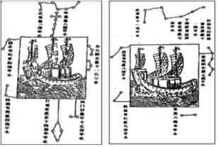
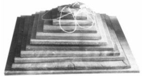
3.2 Celestial fixing Zheng He developed a whole set of navigation technology by looking at stars. Accompanying Zheng He’s nautical chart, there were four stellar diagrams. Figure 3 shows portions of two of them. Those diagrams passed on by Zheng He have not only enabled us to recapture the stars observed by navigators but also revealed the secrets of ancient navigation. Zheng He was able to determine his latitude by measuring the height of Polaris to the north and Southern Cross to the south. Twelve star boards (Fig.4) were used depending on the different height of the stars. The size of the largest board is around 24 cm by 24 cm (12 fingers as it was termed at the time, using the size of human thumb) and the smallest, 2 cm by 2 cm (1 finger), with 2 cm difference in succession (Zhao 2005). By using the attached thread, around 60 cm in length, the observer was able to fix the distance from the eye to the board, thus fix the angle of observation of the board, about 1.9° per finger. When observing the celestial bodies, the observer aligned the star on the upper side of the board and the horizon to the lower side, and thus the height of the star was determined. According to different heights of the stars, different sized boards could be used. By using Zheng He’s method, the positioning error could be controlled within 4.5 nautical miles, which was far superior to the general level at that time (Zhao 2005). Figure 3. Portions of stellar diagrams Figure 4. Star boards Menzies (2003) describes quite clearly astro-navigation of the fleet. The fleet used Polaris in the northern hemisphere. But when they were in Indian Ocean, and altered course to the southwest, southern Africa. Polaris, the Chinese guiding star, would have sunk closer and closer to the horizon and become invisible at 3°40¢N, north of Mogadishu in Somalia. Until they found another guiding star in the southern hemisphere to fulfil the same purpose as Polaris in the north, they were sailing into the unknown. The Chinese needed a star in the southern hemisphere to replace Polaris in the northern, and in the event they selected two: Canopus for latitude and the Southern Cross for navigation, they would have to sail far into the icy waters of the Deep South to locate the stars. To use Canopus for latitude, the Chinese had to determine its precise position by sailing to a point directly underneath the star. The Southern Cross points to the South Pole, but unlike Polaris, it is not directly above the Pole. To be able to use the Southern Cross for accurate navigation, the Chinese also had to locate its position in the sky – its height and longitude. Once again, the only way to calculate the precise position of the Southern Cross was to sail to a position directly beneath it. Menzies believes that only when Canopus and the Southern Cross had been located could new lands in the southern hemisphere be accurately placed on charts. When they reached Mount Adams in the West Falklands, the Chinese cartographers were nearly underneath Canopus. They were taking such pains to fix their position so that they could calculate their precise latitude: 52°40¢S. By cross-referencing Canopus to Polaris they could establish Canopus’s height and then use that star to obtain their latitude anywhere in the southern oceans. |
|
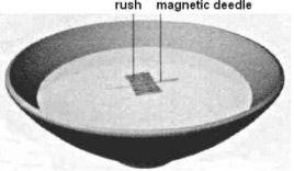
3.3 Nautical charts Figure 5. Zheng He’s Nautical Chart The charts utilize traditional Chinese landscape painting techniques to portray features such as mountains, islands, bridges, temples, and cities in detailed perspective. Figure 5 illustrates a portion of the chart. These graphic representations enabled the navigators to more easily identify important geographical features from shipboard. The charts include over 530 place names, including over thirty Asian and African countries and regions. Over fifty separate routes are delineated. Navigational data inscribed along the routes, such as compass headings and time notations. Zheng He’s nautical charts are of great both historical and practical value. These charts fully reflect the high level of navigational expertise of the time, and indicate that China’s maritime technology had essentially been perfected. It has been proposed that when Columbus, da Gama, Magellan and Cook later made the “discoveries’, they were carrying copies of the Chinese maps with then when they set off on their own journeys into the “unknown” (Menzies 2003). 3.4 Course and speed measuring Compass was the main means used by Zheng He in his epic ocean voyages. The compass was used to fix the direction and “geng” which recorded by Chinese era is used to measure distance. The compass used in the treasure ship was a kind of “wet compass”, that is a needle floating in water contained in a circular box with the compass points carved on wooden rim. On the compass there are 24 scales. Each scale, marked by different Chinese characters, represents a direction. The characters provided a way to mark the direction course route lines on the charts. The ship may follow one particular scale mark or follow a point between two scales. Figure 6. Magnetic compass Figure 6 shows the magnetic compass used by Zheng He’s fleet. The lower part of the figure is a replica of the compass and the upper shows the bearing correspondents of the Chinese character marks. Figure 7 shows a simple form of a “wet compass” (Xin Yuan-ou 2003). Figure 7. Simple form of “wet compass” Zheng He’s fleet used hourglass to measure the distances it covered. It was an instrument for measuring time by the trickling of sand through small opening from one glass bulb to another below it in fixed period of time, usually a “geng” (Information Office of Fujian Province 2005). “Geng” is a time recording unit, representing one of the five two-hour periods of a night, but here it refers to a unit of distance. Usually one “geng” was 60 li, about 30 kilometers. When taking the measure, they threw a wooden plank into the sea and then walked to the rear of the ship at a certain fixed speed to gauge the ship’s speed. Then route and distance were calculated and drawn on a map. That is what we see as the navigation chart, a precious material for studying Zheng He’s western ocean voyages. By using compass and the “geng”, navigators would know the position of the ship in the vast seas. 3.5 Organization The eunuch captains and admirals of these great treasure ships were men of awesome ability but, like the European explorers who followed them, they often drew their crews from the lowest levels of society. Most were criminals, sent to sea in lieu of imprisonment or internal exile, and in some respects life as a crewman was far better than a prison sentence. They were provided with a uniform – a knee-length white robe – food and wine, and were well cared for when at sea. The admiral’s staff included 180 medial officers, and every ship and company of soldiers had a medical officer for every 150 men. There was a varied and plentiful diet on the treasure ships, but the perils of voyaging through uncharted waters meant that life expectancy was short: only one in ten returned from the great voyages of exploration and discovery. But those who had survived the earlier voyages of the treasure fleets had been well rewarded. They were often freed and given endowments or pensions. Like all soldiers, the Chinese were superstitious. Each of Zheng He’s ships had a small cabin dedicated to Ma Tsu, the mariners’ deity, and prayers were said to her every evening before supper. When the crew went ashore in foreign lands, they carried round bronze mirrors to ward off evil spirits; on the reverse was the eight-spoked Taoist wheel. The elite of the crew were the navigators and compass-men, operating from an enclosed small bridge and living and dinning separately from the rest of the man. The junks also carried artisans and craftsmen of every description, capable of performing any task. Caulkers, sail-makers, anchor- and pump-repairers, scaffolders, carpenters and tung oil painters would keep the ships in good repair on their long voyage into the distant oceans. Tone-carvers and stonemasons were also embarked to leave permanent legacies of the fleets’ voyages across the world (Menzies 2003). |
|
3.6 Provisions Provisions were fundamental and critical for sustaining the long voyages at sea. The staple foods – Soya beans, wheat, millet and rice – were carried in separate grain ships, enabling a fleet to stay at sea for several months without replenishing supplies. Soya beans, grown in tubs all year round, were used in several ways. Soaked in water, they sprouted yellow curls from the green bean. The sprouting process increased the content of ascorbic acid, riboflavin and nicotinic acid, the basis of vitamin C, and protected the crew from the deficiency disease scurvy. The Chinese know well the dangers of scurvy and the remedies to prevent it. Enough citrus fruits – limes, lemons, oranges, pomelos and coconuts – were taken aboard to give every man protection against the disease. Some of the rice was brown, not polished, and the husks contained vitamin B1. As a result, beriberi – a disease causing degeneration of the nervous system – was rare among the crew. Fresh vegetables mainly comprised cabbages, turnips and bamboo shoots. When they ran out, the sprouting soya beans were particularly valuable. Soya beans also produced “mike”. When boiled, it became curd, or tofu, rich in vitamin D, while fermentation of soya produced soy sauce. Tofu and vegetables were flavoured with a sauce made from fermented fish, soy, dried herbs and spices, or glutamate made by chewing wheat flour. The grains were chewed, spat out into a container and left to ferment. The method is still used in South America today. Noodles, pasta, and dumplings were also made from wheat flour. Sugar cane was used to sweeten dried fruit and was also chewed raw by the crew. Fruit and vegetables were preserved in ingenious ways. Fruit was dried or caramelized, pears, bamboo shoots and grapes were buried in sand, and vegetable was salted, pickled and marinated in vinegar and sugar. Meat was limited, for the most part comprising Chinese pigs, dogs bred for purpose and frogs kept in tubs. Chickens were kept for divination and were never eaten on board, but fresh, salted, dried and fermented fish were plentiful. They were caught by the trained otters, working in pairs to herd shoals into nets, and by an array of hooks and nets. They crew drank green oolong and red tea, carried in both leaf and cake form, and rice wine was hugely popular. Wine was also distilled into liqueurs, brandy and vinegar. The junks required huge quantities of fresh water for crew and horse and replenished their tanks whenever an opportunity arose, but they also knew how to distil it from seawater, using paraffin wax or seal blubber for fuel. Their capacity to desalinate seawater and the fresh vegetable they carried gave them the ability to cross the broad oceans. 4 IMPACTS AND SPIRITZheng He’s expedition scores perpetual contribution to the politics, economy, and culture, external contacts of the ancient China, as well as the world civilizations and other expeditions followed. It helped China know the world in ancient time (Fig 8). It has turned to be a spiritual wealth and an excelling cultural legacy of China and even of the world. Figure 8. 1763 Chinese map of the world, claiming to incorporate information from a 1418 map. Discovered in Shanghai by Liu Gang in 2001 According to Menzies (2003), Magellan never claimed to be the first man to have circumnavigated the world; never the less, he was still in an amazing feat. Magellan, Dias, da Gama and Cabral were very skilful navigators and seamen; they were also brave and resolute men with awesome qualities of leadership, but not one of them actually discovered “New Lands”. When they set sail, each one of them had a chart showing where he was going. All their “discoveries” had been made nearly a century earlier by the Chinese. Nor did Christopher Columbus ‘discover’ the Americas. Far from setting sail full of fear that his fleet might fall off the edge of the world, he knew where he was going, as can be seen in excerpts from his logs when he was still in mid-Atlantic. Since that Vasco da Gama was not the first to sail to India round the Cape of Good Hope, that Christopher Columbus did not discover America, that Magellan was not the first to circumnavigate the world, why they deserve these glories? Because they were on the shoulders of giants! All the charts they used contain information that can only have come from cartographers aboard the pioneering Chinese fleets. Unlike conquering other nation, collecting treasure or expanding territory, peace and amicability are Zheng He’s spirit. In undertaking the ocean-going voyages, Zheng He pursued a policy of peace as laid down in the imperial edict, which said: “you may go the way of the heavenly kingdom, strictly abide by words, keep in bounds, and refrain from bullying the weak and share peace and happiness in the world” (Information Office of Fujian Province 2005). Through the voyages, Zheng He safeguarded peace, sowed the seeds of amicability/friendship and deepened the understanding of the people of other countries. As a friendly envoy of the Chinese people, Zheng He got on quite well with the local people. During his voyages, group after group of foreign envoys and business people came to China and more and more Chinese went down the seas to seek a living outside China and they got melt into the local communities. Zheng He treated countries with a relatively backward economy and culture equally and spread the civilization of the Chinese nation, thus contributing to the cultural exchange and mutual understanding between China and foreign countries. Many neighbouring countries sent their envoys to China. In some countries, even the kings went in person to China to conduct exchanges. The kings of the kingdoms of Sulu and Borneo all headed their ministers and other official to China to learn. When the King of Sulu died in China, the Ming government buried him with a ceremony. According to statistics, there were 90 diplomatic missions coming to visit China during the period of Emperor Zhu Di alone. During the more than 30 years, 292 Asian and African countries sent 400 diplomatic missions to China, with each mission making up of 60-70 people or even as many as 500-600 people. Historical records show that in the 21st year of the reign of Emperor Zhu Di, a diplomatic mission of more than 12000 people came to visit China (Information Office of Fujian Province 2005). |
5 CONCLUSIONSZheng He was a great navigator in the history of China and the world and a momentous pioneer in the great geographical discoveries. Zheng He’s voyages were the record-breaking feats in the history. He carried out the expeditions earliest in time and largest in fleet scale. He developed and employed the most advanced shipbuilding technology in his time. The most sophisticated and systematic navigation techniques were fully demonstrated in the voyages. And the most powerful navy force was well established. Zheng He’s great voyages are the magnificent landmarks not only in China’s political and diplomatic history but also in navigational annals of the world REFERENCESChen, Xiaodong 2005. A Comparison between Zheng He’s Expedition and Westerners’ Pioneering New Routes. International Academic Forum in Memory of the 600th Anniversary of Zheng He’s Expedition ‘Carry on Civilization, Open to the World, for Peace and Development’. Nanjing, China. 4-7 July. Information Office of Fujian Province 2005.Zheng He’s Voyages Down the WesternSeas. Beijing: China Intercontinental Press. Ma, Hongxia et al 2006. Rational Think for the Different Result of Navigation between China and the West, Journal ofHenanNormalUniversity 33 (2): 135-138. Menzies, Gavin 2003.1421 The Year China Discovered the World. London: Bantam Books. Walner, Ann 2005. Zheng He in American Classroom: Some Approaches. Symposium on Memory of the 600th Anniversary of Zheng He’s Expedition ‘Zheng He’s Expedition and the world civilization’. Beijing, China. 11-12 July. |
|||||||||||||||||||||||||
|
|||||||||||||||||||||||||
|





 (7 votes, average: 3.43 out of 5)


