| Surveying | |
Systematic cadastre surveying and inventory of real estate objects in Azerbaijan
This paper describes the methods used for the implementation of land administration in development cooperation projects, especially in Azerbaijan |
 |
|
|
In all development cooperation projects in the field of land administration, initially, the particular national and regional characteristics must be considered, especially regarding institutional, legal and technical conditions. Additionally the Know how level in the partner organizations and in the private sector must be considered adequately. Finally, the expectations of the target group must be respected. These expectations should be harmonized with the project goals.
GCI – Dr. Schindler Geo Consult International GmbH & Co. KG (GCI) has been active for more than 20 years in more than 25 countries in international projects in the field of land administration and land management. The project countries are located in East and South East Europe, Africa, Central and South East Asia and Latin America. Many projects were executed in cooperation with GFA – Consulting Group GmbH, based in Hamburg, Germany.
This paper, prepared for the Journal “Coordinates”, describes the methods used for the implementation of land administration in development cooperation projects, especially in Azerbaijan, and the experiences made by the consortium GFA/GCI.
Selected aspects of surveying and data collection in land administration projects
Expectations and adapted methods in development cooperation projects
It is generally acknowledged that in a couple of West European countries, also in Germany, the land administration (real estate registry and land register) is realized at a very high level. In the context of development aid this can redound to disadvantages in the international competition. It’s presumed, whether consciously or not, that the experts in developed countries are to accurate and therefore to expensive. But if a government has decided to establish a nationwide land administration the government is often influenced by what is presented at international conferences and exhibitions (e. g. INTERGEO©). The decision-makers don’t realize that the high quality level in Western European countries and other developed countries is not arose in two or three years.
Therefore it’s not easy for consulting companies to fulfill high quality standards while being simultaneously measured on a value of money which make it difficult to deliver results that meet the demands of quality. Therefore it is important, to use adequate methods and technologies which meet the requirements of development cooperation projects, e.g..:
• Involving local experts for the creation of local resources at acceptable costs,
• preferably digital techniques for reducing errors,
• use of modern and high effective methods to accelerate surveying and data collection,
• complementary consultancy services to improve the legal framework,
• involving owners and local administrations to improve legal certainty of border determination and data collection,
• continuous training and systematic controls as indispensable quality management components.
As a consequence the used methods have to offer a high output at minimal costs per parcel and legal entity.
In many projects, especially in technical development projects GCI could contribute components for the systematic implementation of a land administration system. In two financial cooperation projects all different aspects of the systematic cadastral surveying for the preparation of owner registration were deployed.
In a KfW (German Bank for Development) financed project in Georgia from 01/2000 to 02/2008 a systematic surveying for a new cadastral surveying was conducted. In this surveying 1.4 million parcels and ca. 1.0 million additional legal entities (apartments, buildings) were recorded and prepared for a first registration. Additional surveying results and attributes were adopted from cooperation projects of other donor organizations and were integrated into a consistent geodatabase for the national cadastral and registration agency NAPR.
At the end of the project ca. 3.5 million parcels and ca. 1.0 million additional legal entities were saved in the geodatabase. The „National Agency of Public Registry“ (NAPR) already took responsibility for the data and data updates in the final stage of the project. NAPR improved consequently the usability, extended the possibilities of using the data and took care of the procedures for the ongoing updates of the cadastral and register data. These actions led to the result that Georgia, in the last years, rank first several times in the World Bank Ranking „Doing Business”.
Since the beginning of 2011 GCI operates with the consortium partner GFA Consulting Group in Azerbaijan. In a concept phase from 01/2011 to 10/2011, in close cooperation with the State Committee for Property Issues (SCPI), it was proved whether the required conditions existed to implement a systematic cadastre and register system. The following aspects were proved:
• Existing legal framework,
• political willingness and governmental mandate of the responsible agency SCPI,
• availability of local experts from the public and private sector,
• quality of the required technical infrastructure (internet, GNSS reference service),
• the owners willingness and interest to cooperate,
• efficiency of the planned surveying and collection methods,
• financial requirement for future project areas.
The concept phase succeeded. In the frame of intergovernmental negotiations Azerbaijan and Germany agreed to continue with the planned implementation phase. In 10/2013 this phase started with the goal to survey systematically and completely the districts Ganja and Sheki, located in the west and northwest of Azerbaijan. Additionally all relevant attribute data should be collected in digital form. The data for ownership registration is recorded through surveying and data collection. But the registration itself is only fulfilled on request of the owners. Therefore the Azerbaijanian partners name the project “systematic cadastre inventory”.
For the implementation of this project the consortium GFA/GCI can use the rich experience and expertise of the Georgia project 2000-2008. The proven surveying and collection methods are used again. Nevertheless there are significant technical improvements in the current project, e.g.:
• Utilization of CORS (permanent stations for GNSS reference service),
• collection of attribute data in digital form using tablets,
• utilization of open source software for data examination and data storage in a temporary database
As part of the general government task about 170,000 parcels are measured in the Ganja and Sheki regions.
When the pilot project finished in 10/2011 the estimation was 100.000 parcels to be surveyed in both districts altogether. But the real estate market evolved in an accelerated way during the past five years. As well as in the second biggest city of Azerbaijan Ganja as in the more rural district Sheki private construction works increased enormously. That’s why the real number of parcels doubled in some regions compared to initial estimations. This is a clear sign for the necessity of the executed inventory of all real estate objects. At the same time it is obvious, that communal and state institutions don’t have reliable information on existing real estate so that they are able to fulfill their administrative tasks only in a severely limited way. It gets very clear, that the newly collected cadastre data are needed not only for assuring ownership but also for many additional administrative tasks. The meaning of multipurpose cadastre becomes very clear here.
Below some essential aspects of the methodical approach of the surveying and data collection are highlighted. Systematic local surveying versus digitalization of orthophotos
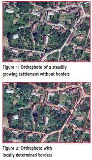
At international conferences, especially in the context of developing cooperation, the digitalization using orthophotos is publicized. In this matter cost benefits and the good readability of images are playing an important role. But this method is not suitable neither for Georgia nor in Azerbaijan as the dominant method because:
• Dense vegetation in settlements impede the identification of borders. In many cases the lines of the borders at the site are not marked. Sometimes they are marked just with simple means (wire, laths, decayed fences). They are not visible on orthophotos.
• In cities usually there aren’t demarcations between private, municipal and governmental areas. In many cases these demarcations must be determined by a concerted site inspection. Only afterwards a surveying of the areas is possible.
• The use of orthophotos to determine the demarcations of arable land, meadows and orchards as well is problematic because many times the areas are leased by several owners but are cultivated corporately. Therefore the cultivation borders are not the same like the property borders.
The problems described here are illustrated in figures 1 und 2.
In Azerbaijan, as well in Georgia, the principle is used: „A cadastre must be realized by foot.“
After the agreement of the local demarcation the border is determined by terrestrial surveying. Therefore a Digital Plan Table (DPT) is used. DPT consists of a GNSS-Rover, a field computer with the mobile GIS PENMAP and an inclinometer enabled laser distance meter. All single components are connected via Bluetooth.
Using this equipment most of the points can be surveyed directly. In case of shadowing or in roofed courtyards auxiliary methods may be applied. Therefore auxiliary points are determined using the RTK mode of GNSS. With these points the relevant border and building points are determined using special geodetic methods like bilateration, embedding in a straight line or extension. The coordinates from the GNSS-Rover and the distances measured with the laser distance meter are transferred to the mobile computer via Bluetooth. Subsequently the leader of the surveying team can analyze the data on-site using PENMAP and he can create the preliminary cadastral map.
In Azerbaijan for the field work a total of 25 DPTs are used. Each system consists of a Trimble R 10 or R 6 receiver in combination with the PENMAP software. Trimble RTX technology inside of R10 allows the use of GNSS in remote regions without CORS accessibility.
In the surveying team two qualified local persons are working. With this method 20 to 25 parcels within settlements and 30 to 50 parcels outside settlements are measured during an 8-hour day. The applied surveying method is extraordinary effective and is one of the main reasons that the costs per parcel in Azerbaijan currently only amounts to ca. 20 $ US. These are not only the mere surveying costs of the local surveying companies but the total costs. These costs comprise as well the costs for the following components and services: Acquisition of the surveying systems and computers, data collection in the field, training of local staff, consulting services by international and local experts, quality management by the consulting company.
At the end of the working day all data is transferred into a temporary database that was developed by the consultant especially for the project. The database uses several test methods (topology, plausibility, completeness) to check the required data quality. Simultaneously all data is saved and stored until completion and delivery of a complete lot.
Utilization of orthophotos and CORS
In spite of the facts mentioned above orthophotos (if available) are used additionally to terrestrial surveying, especially for information with little precision requirements, e. g.:
• Forest and municipal meadows,
• water,
• mountains,
• road axes,
• (partly) municipal boundaries.
The orthophotos of a particular surveying area are stored as tiled images on the field computer. Thus the team leader has the possibility to compare the surveying results with the orthophoto to check plausibility errors. Unacceptable deviations are examined directly on-site.
During the project in Georgia 2000 – 2008 Continuously Operating Reference Stations (CORS) were in development stages, even in developed western countries. In Georgia they even did not exist. Therefore DPTs with two GNSS receivers together with base and rover were used. Beforehand densification points were determined with reference to the national control network. From the densification points temporary auxiliary points were determined using RTK (long exertion, dual measurements) directly on-site. On these points the base station were mounted which provided the necessary correction data to the mobile rover. That way a positional accuracy of 10 cm was achieved throughout Georgia.
In this regard the conditions in the current project in Azerbaijan are much better. The implementation of CORS already started in 2010. Unfortunately it wasn’t yet ready for operation during the concept phase in 2011. However, since the beginning of the implementation phase in October 2013 the reference service AZPOS is available and usually works reliably. Sometimes limitations occur due to shortened internet access which make it impossible to receive correction data. The same problems occur in some remote mountainous regions and mountain villages. In such circumstances base and rover are used. Overall, it has to be noted that the availability of the CORS network facilitates the work process and increases the efficiency of the surveying teams.
Determination of borders in cooperation with the owners
The on-site determination of the borders in cooperation with the owners is an important element for accepting the first cadastral surveying by the people and the administration.
The cooperation is prepared by informing the people. Before the start of the surveying the population in the affected areas is informed by local television, radio and press. The advantages of a systematic cadastre inventory is explained and the owners are requested to submit an application for property registration to the registry agency. Additionally, the responsible surveying companies inform every owner via a flyer ca. 3-5 days before the surveying date about the upcoming surveying. This guarantees that in most cases, at the first attempt, the access to the properties is granted. In this regard it is advantageous, that in many houses still three generations are living together. Furthermore, by far there is no full employment, especially in rural areas. This procedure achieves an intense inclusion of the owners in the surveying process and leading to a high acceptance of the results by the population.
Collection of property data
In the frames of systematic re-measurement of all properties not only the boundaries, buildings and land use will be measured, but also numerous property data about the owners, real estate (buildings, apartments, commercial units) and rights to the property (e. g. servitudes) will be collected. This makes absolute sense in the context of an initial systematic inventory of all properties. As in Azerbaijan the registration of rights to property takes place only on request, it is expected that many months or even years pass till the full legal registration of all property takes place. Since the property data can be used in addition to the registration of property in the sense of multipurpose cadastre for various administrative tasks, their collection is convenient, even if some of the information, in particular in terms of ownership, until the legal binding registration have only a formal character.
To collect the property data, a special software has been prepared by the consultant based on the open-source application ‘Open Data Kit’ (ODK). ODK is used by an employee of one of the surveying teams on a Tablet PC to capture property data digitally parallel to the surveying works. In addition, all relevant documents are photographed with the tablet PC and linked to the right object with an ID. The following documents are included, if exist:
• Personal document of the holder / owner,
• possession of evidence, such as building permits, house books, etc.,
• documents from the land reform.
If the property has already been registered, it is only checked, if the registration number detected by the surveying team is identical with the number in the document. Only if there are differences, as a precaution, all property data is collected again. In such cases the registration authority is responsible for elucidation of the contradictions. In addition to the various documents one or two meaningful photos related to the property are made and stored for all buildings. These images can be used in conjunction of the property data with the buildings, e. g. for approximate valuation, for urban planning as well as for building regulation duties.
Use of existing data from existing archives
In the frame of the systematic inventory of all property data from reliable already existing data sets is used.
This applies mainly in two cases:
a) Although the registration process has so far been relatively expensive and complicated for Azerbaijani relations, many owners have already let to register their properties in the sense of sporadic registration.
The boundaries and buildings are, however, re-measured in each case. This is strongly recommended because the measurement results are often faulty in combination with the sporadic registration. This is mainly due to the following reasons:
• lack of surveying equipment,
• lack of knowledge for correct use of GNSS and electronic tachymetry,
• measurement with local control points without connecting to the official position reference system,
• imprecise identification of the boundaries, etc.
These inaccuracies and measurement errors can be detected and corrected only in the context of the systematic cadastral surveys. For this reason, the already registered lands were not recessed from the systematic remeasurement. However, the property data is retained from the existing registers.
b) With regard to the apartments and commercial units, there are very detailed documents by the local authorities. This is due to the fact that in the socialist times of the Soviet Union living space was very limited and was therefore managed carefully by the “Bureau of Technical Inventory” (BTI). This tradition was continued, although after the privatization a state or municipal housing management no longer is required. By now it doesn’t take place anymore. Nevertheless, all apartments and commercial units are continued to be registered by real allowance and tangible data collection for the creation of a “technical passport” for each object. These data are taken from analogue documents and are entered into the databases by the contracted survey companies in Azerbaijan. Due to the quality, this data can be used further for the systematic inventory and transferred to the unified database. This approach contributes to cost reduction in the systematic inventory, especially for the apartments.
Tasks of the consultants in the KfW financed project in Azerbaijan
The financing of the project in Azerbaijan has been agreed as a result of government negotiations between the two countries Azerbaijan and Germany. It was decided that an international and experienced consulting company will assist in the implementation of the project.
Below are shortly represented some of the key tasks of the contracted consortium GFA/GCI, without claim of completeness.
Project Management
If projects concerning the implementation of a land administration are awarded to suitable consulting companies, this companies are responsible for the realization of the project in technical, financial and personnel terms and in terms of achieving the objectives and effects.
The consortium GFA/GCI supported SCPI with relevant activities to realize the project. From the beginning the main focus was to build up local capacities and to enable them to execute the necessary works. The consultant focused mainly on following activities:
• Elaboration of the technical instruction for systematic inventory of all real estate objects including an exact cadastral survey
• Elaboration of a guideline for quality assurance within the project
• Supporting SCPI on tendering surveying technology Training of more than 80 technicians of local surveying companies
• Training of approximately 10 GIS operators of private companies
• Supporting SCPI on tendering the lots for surveying works within the project area
• Supporting and control of private companies during field works and processing of cadastral (GIS) data
• Reporting on project progress
In private sector so-called “turn key” projects are common, in which the recipients of services are handed over with turnkey products. In development cooperation projects the goal is very different from that because the partner countries should be involve in all planning and decision processes. It is important to enable the partner countries, upon completion of projects, to apply the newly established procedures, methods and more efficient processes independently and to achieve the associated effects in terms of a sustainable strengthening of their economies.
Creating the legislative framework
In addition to the project management one of the most important tasks is the creation of proper conditions. Many project approaches neglected that a systematic creation or improvement of land administration usually requires an adapted legislative framework, where the basic relationships of the actors to each other in this sector are regulated. This includes both institutional, organizational and technical issues. What’s the use of, for an example, a fully digital data flow in a project, if such a procedure is not permitted by law or regulations?
A thorough analysis of the existing legislative framework has to follow a recommendation for urgent new regulations on a statutory, regulatory or technical requirements level. It should be a maxim of every project manager to involve local experts, both in conducting the analysis and for the necessary conclusions. Additionally, at an early stage policy authorities should be involved. Once it is determined what needs to be regulated, the draft of the new regulations has to be developed corporately with the involvement of experts from the project country. It can be quite useful when a first draft will be prepared by the consultant, which then serves as a basis for discussion. So already exemplary methods and procedures were tested in the pilot process in 2011. As a result, technical requirements have been developed and adopted for this particular case. Therefore the results of the data collection can be transferred and used in the official register.
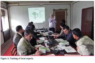
Education and training
In the context of sustainable project implementation emphasis must be placed on ensuring a broadest knowhow transfer to local institutions and experts. The private sector should be involved as well, because in most land administration projects private surveying companies are responsible for carrying out of the surveying work and the attribute data collection. The trainings were usually designed for different levels. Both the technicians and engineers who will carry out the field and office work as well as decisionmakers should be trained (figure 3).
It must be guaranteed, that a sufficient number of employees are sufficient qualified. Because experience has shown that the fluctuation of the well-educated and mostly low-paid employees in the administrations is very large. Especially qualified experts who have been trained during a project have better earning potential in the private sector. Therefore, you meet very often new staff, which must trained again, since trained people very often leave the public administrations.
Another important aspect of training programs is the preferably concept of “train the trainer”. In larger projects suitable trainees are found in competitions, which are trained especially intensive in order to independently conduct training in the future in cases of proven merit. They act as multipliers of the training. This ensures that even after completion of a project experts can continue to be educated and trained.
Quality Management
For data collection methods it is important to provide an effective quality management. Since in accounting process, further processing, storage and output of data errors can occur, they should be identified and eliminated. At the same time it is necessary to check the completeness, accuracy and consistency of data. Along with the verification and documentation of quality of pragmatic origin, status and time accuracy of the data, the quality of the received data will be guaranteed.
Collecting and processing of data will be carried out after extensive (productive) theoretical and practical training of all personnel involved, both the private sector and the administration. Regularly occurring mistakes and wrong methods will be identified in such a way until they become typical. The local project workers and the employees of companies involved and the administration will be trained in the use of quality control measures. That way they could execute these tasks themselves in the future.
Software development for quality testing and data management
For a sustainable use and for the acceptance of software in developing cooperation project a participatory approach is necessary.
In nearly all land administration and cadastre projects, in which GCI is involved, a geographic information system (GIS) and a geodatabase is used. The development of the database is the first step in the process of the software development. During intensive discussions the data model and the “digital illustration” of the working processes are developed. Subsequently the design of user interfaces and the code programming is realized. During first test runs the database, GIS and code is adjusted.
Below the common procedure of a participatory software development is described (as it is done by GCI in Azerbaijan):
1. Development of a simple example application To give a first idea of the software to the stakeholders a first example application is developed. Using this software the users gain experience and know-how. On this basis the further development is realized in a collaborative manner.
2. Database development
2.1 Requirement analysis During the requirement analysis the consultant together with the decision makers and users clarify which processes should be supported and which information is needed by the users.
2.2 Conceptual design The conceptual design is a plain structured model containing the database objects and their relationships. Generally the design is illustrated using the entity-relationship-model (ERmodel). The terms used in the conceptual design originate from the ‘real world’, using words of the users everyday work. The conceptual design is created in close cooperation of users and developers.
2.3 Logical design and implementation The logical design is used to transfer the conceptual design into a logical database model like the relational data model used by the database management software PostgreSQL. Finally, on basis of the logical design, the database is implemented. The logical design and the implementation is generally the task of the developers. Nevertheless, if qualified local developers are available, they are involved in this working step. Sometimes local developers are trained beforehand, as it was realized in a GIZ project in Cambodia in 01-02/2016.
3. Design of graphical user interfaces In cooperation with the users the design of the graphical user interfaces is determined using sketches (analog or digital). That way, the users get an impression of the software and may contribute to it at an early stage, which is very important for the acceptance of the software.
4. Software programming If possible, local developers are involved for programming tasks supporting the main developers. By favorable circumstances qualified persons are available already. Normally, the staff is low qualified and must be trained according to the requirements. The inclusion of local developers is crucial for the sustainability of the software because they are responsible for the maintenance and enhancements of the software after the developing project had finished.
5. Presentation of a first version After the completion of the programming tasks a first application version is presented to some users. Based on user feedback the software is adjusted. Generally, only small adjustments are necessary.
6. Implementation, training and support After successful test runs the software is implemented. If the local project partners already have digital data, they are transferred into the database for using the software immediately. Subsequently, the users are trained intensively – preferably, following the principle “train the trainer”. After finishing the project these trainers serve as contact persons for the users and take care for the continuance of the software. The main developers should be reliable contact persons even after the departure from the project country and should support the users via online services as Skype or TeamViewer.
Using open-source software QGIS and PostgreSQL/PostGIS
Not only in the cadastre project in Azerbaijan, GCI is using open-source software. Only if there is no suitable open-source software for a particular task proprietary software is used. Compared to proprietary software open-source software has many advantages, especially for the use in developing cooperation projects.
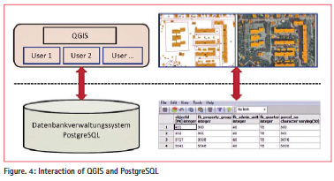
In development cooperation projects GCI uses two open-source software applications: the geographic information system QGIS and the database management system PostgreSQL/PostGIS. Both applications belong to the most used and popular open-source products. Because of the popularity, the professional organization, the active communities and a sound financing by sponsorship operational safety is guaranteed in the long term.
The applications interact via interfaces in an optimal way (figure 4). In the database all data is stored. In addition the database is responsible for spatial analysis and geometry processing. In QGIS the data is presented in maps. QGIS offers the possibility to create extensions to supplement the basic functionality with custom-built functions. Thus, project-specific menus and dialogs for a particular process can be created. The extension dialogs in QGIS can be translated in any language. This is a big advantage in countries with non popular languages as in Azerbaijan, Mongolia, Laos etc. In development cooperation projects this advantage leads to more acceptance of the software.
Conclusion
I n the frame of the project SCPI, the consultant and involved private companies contributed a lot to establish a sustainable land administration system in Azerbaijan. In the course necessary data was not only collected to register ownership but also for a sustainable Land Management. The Republic of Azerbaijan is on a good way, but there is still a lot to do, e.g.:
• Simplification of first registration process
• Reformation of the surveying and cadastre law
• Continuation of systematic first survey in additional districts
• Establishment of an effective system of cadastre maintenance on demand Provision of all cadastral data to state and communal institutions to improve their administrative performance
The experiences gained during the project show definitely:
• The technologies applied are highly efficient and guarantee a sound legal security, hence the owners are involved in the process of determination of the parcel boundaries
• The used surveying equipment is highly efficient and works also with limited GNSS availability reliably
• Open-source software can be used reliably for data processing, checking and storage
• The methodology of project execution specifically involving the private sector to a large extend is reusable in other countries.
References
Open Source 2015. https://opensource. org/osd-annotated, last access 30th of November 2015.


 (3 votes, average: 3.00 out of 5)


Leave your response!