| Innovation | |
Make maps quickly
|
||||||||||||
|
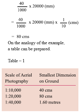
Seven out of ten customers of surveys and mapping who talk to the suppliers (consulting fi rms of surveying agencies) demand their maps to be delivered `yesterday’(!) or indeed as early as possible. These customers are `decision-makers’ who have taken some months (if not years) to come to the demand level! Same is the situation in respect of the tenders in mapping discipline. All the risks and uncertainties are put on the door of the suppliers / contractors. One should realize that although the surveying and mapping process never costs more than 1 or 2 percent of total budget, the same is not true when it comes to the time taken for the mapping project. The fact is that many projects are delayed just because the survey data of right quality and proper map was not made available to the engineer / planner. The above scenario, although quite common and acceptable through usage, should make people think about the cardinal question – Can we cut short or minimize the time taken for the survey process and deliver the map tomorrow if not yesterday? Survey profession will defi nitely earn brownie – points if the process becomes quicker. This paper tries to answer this question. Some innovative juxtaposition of the photogrammetric production process has been suggested towards this goal. In order to reduce the time of production, we have to examine the photogrammetric production processes. The sub-process or various steps in the photogrammetric processes are further analysed towards arriving at the solution. Aerial Photography – Treat this as 90% MapThe aerial photography in India is carried out by the National Remote Sensing Agency, (NRSA) located at Hyderabad. The specialized aircraft and other equipment are also stationed at Hyderabad. The cost of aerial photography, therefore, very much depends on the distance of the desired survey site from Hyderabad. The security clearance of the aerial operation is taken by the NRSA but it takes a few months. Besides, the fl ying season commences in September and fi nishes in March / April. Looking at this scenario, the customers are well advised to enter into dialogue with NRSA right at the conception stage of the Project and not wait for the sanction of the Project. There is no cost of discussions leading to the stage of obtaining security clearance. To give an idea, the cost of the aerial photography for an area in Delhi may range from Rs 40 to Rs 50 per hectare on 1:10,000 scale. The cost Ground Control – Vital Input to PhotogrammetryWhen Photogrammetry is employed as the main production technology, there is considerable (almost 60 to 70%) reduction of ground control work in the fi eld as compared to purely ground based traditional techniques. However, Photogrammetry stipulates a minimum number of It is presumed that the ground control points will be provided with the help of Global Positioning System (GPS in differential mode). These points are further connected to the Survey of India Stations and Bench Marks. Aerial Triangulation (AT) and Digital Terrain Model (DTM)This is an essential photogrammetric operation in which initial ground control (as mentioned in 2.2) is augmented by a set of procedures on a photogrammetric machine. The result is that all the overlapping aerial photographs (stereo-models) will have control points at optimum places. These control points obtained after aerial triangulation are marked on photographs and are later required for producing mapping details (x, y and z) in case line map is required. A fully digitised vector map can also be produced at this stage. Digital Terrain Model is produced using a mesh / grid of elevation points. Closer the grid, the more accurate is the DTM. The DTM provides a `well approximated’ model of the terrain. The digitised data in DTM form can be further utilized to generate contours and / or Orthophoto. Photogrammetry Based Mapping (Plotting)The photogrammetric model is set on the machine very accurately with the help of the augmented points. The digitisation of the mapping details (topography) and the elevations / contouring is done automatically while the operator is going over the details of the 3D model through observation – system of the machine (photogrammetric plotter). The control points and the DTM are also used for incorporation in the Geographic Information System (GIS) and for generating an Orthophoto. Orthophoto is a digitised transformation of original photograph from which all distortions have been removed and proves more productive than traditional line-maps. The Orthophoto combines the richness of aerial photo and the accurate geometry of a map. Incidentally, the Orthophoto mapping process is also more cost and time effective when compared to line mapping on a photogrammetric plotter. Photogrammetric OutputThe photogrammetric output, as mentioned earlier, can be in the form of a line-map with contours or as an Orthophoto of the area. These are the standard map-forms especially for large-scale work e.g. utility maps of towns, highway corridor maps, water pipe network surveys etc. Field Verifi cation of Photogrammetric OutputThere are many physical features, which are not photographed or are omitted e.g. houses under trees, underground pipe lines etc. These features are picked up by groundvisit. The output is, in general, checked for any omissions or wrong interpretation also. In case the photography is not very old (more than 3-4 years) and the changes on the ground are not many, say 10-15%, the changes can be surveyed on the ground at the time of verification. Photogrammetric Production Process and RecommendationsAerial PhotographyAerial photography, as discussed, should be procured as early as possible. It is a low investment activity yet forms an important step. All (100%) ground-based information is available except the `geometry’ of a map in an aerial photograph. Many requirements e.g. planning process, environmental monitoring, ground water studies etc can be met from an aerial picture. Controlled ModelsThe next stages of fi eld control, Aerial Triangulation and preparation of DTM will add `geometric value’ to the aerial photography. This is the desired stage at which the value added data and the aerial photography can be stored so to say. In other words, it means that the aerial photograph along with its value added data is ready for any mapping requirement. This will be the Photogrammetric Digitised Data Base (PDDB), which can be `retrieved’ to produce a map within a very short time of a week or two. We can forget about the delays of some months if not years if the Data Base is already available in an organization. PDDB will create an effect of fast-forward in a mapping organization like Survey of India, The above concept of Photogrammetric Data Base also facilitates the user-organization to spread its expenditure over a longer period of say 2 to 3 years. Thus, the concentrated load of costly mapping is also easily distributed in budgetary allocation of organizations. The concept is so useful that any user organization requiring detailed and accurate maps can get these very quickly. Achievable Accuracy at Different Scales of Aerial PhotographyThe scale of aerial photography is designed before it is actually fl own. The possible accuracy from the various scales of aerial photography is now discussed. It is assumed that smallest topographic detail on the aerial negative (or diapositives) which is discernable on the photograph ranges from 20 micron to 40 micron, micron being 1/1000th part of one millimetre, Example – Assuming 40 micron on Negative. It the scale of photograph is 1:20,000, the smallest dimension converted in terms of ground will be: The scale of map is generally 4 to 5 times larger than the scale of aerial photography. For example, 1:4000 cadastral map can be prepared from the aerial photography on the scales of 1:15,000 or 1:20,000 scales. Utility mapping for towns, which is required on 1:2000 scale, can be prepared from 1:10,000 or nearby scale. ConclusionThe motivation for this paper started from seeking a solution of a real problem of the map users i.e. the inordinate delay in getting mapdata. The concept of generating the Photogrammetric – Date – Base does solve this problem in two ways. Firstly, by procuring the aerial photography at the earliest and secondly by storing the value added models (partially completing the photogrammetric process). Once the user organizations understand the advantages of the concept, the implementation of the model is quite easy. Another acceptable advantage of the concept is that it facilitates organizations to spread the expenditure over a longer period of time. |
||||||||||||
|
||||||||||||
|


 (No Ratings Yet)


