Odin series handheld receiver by UniStrong
UniStrong (Beijing, China) has released Odin series handheld receiver for GIS data collection. It comes with Windows Mobile operation system, rugged and suitable for field work. It has integrated Bluetooth/GPRS/WiFi, 3 Megapixel digital camera, high capacity Li-ion battery and supports SD card.
www.unistrong.com
Trimble and Critigen extend agreement
Trimble and Critigen announced an extension of the business partner agreement originally established in 2004. Critigen will serve as system integrator and provide data management and visual business intelligence solutions to support Trimble’s technology and products in the utilities, state and local government, and environmental management markets.
www.trimble.com
Hemisphere GPS announces new GPS Antennas
Hemisphere GPS released A52 and A21 – two new antennas. A52 is a multi-GNSS (GPS L1/L2/L5, GLONASS L1/L2, Beidou, SBAS, OmniSTAR, and Galileo E1/E5a and b) precision antenna that is ideal for various applications. A52 can be used in challenging environments as it has superior multipath mitigation, a stable phase center, and strong SNRs even at low elevations.
www.hemispheregps.com
RCMRD and UNOOSA sign agreement
The Regional Center for Mapping of Resources for Development (RCMRD), Ethiopia and UNOOSA signed a cooperation agreement making RCMRD the ninth member of the network of regional support offices which support the implementation of the activities of the UN-SPIDER programme in their respective regions in a coordinated manner by taking advantage of the expertise and capabilities being offered.
www.un-spider.org
New OEMStar™ firmware release
NovAtel released Version 1.011 firmware for their lL1 OEMStar GNSS receiver. It provides improved PDP and GL1DE® filter performance, improved satellite tracking in low signal level environments, improved SBAS performance when operating outside of the standard grid map, and improved time to first fix.
www.novatel.com
Trakm8 selects u-blox GPS & GSM
u-blox and Trakm8 announced a new, advanced remote vehicle monitoring system which relies on u blox’ leading GPS and wireless module technology. The solution includes all hardware, software, and system integration services.
www.u-blox.com
POS LV V5 by Applanix
Applanix released the POS LV Version 5. Now with a POS Computer System (PCS) that is half the size of the previous version, ruggedized and fully sealed, the POS LV V5 delivers accurate, uninterrupted positioning and orientation information from a moving vehicle.
www.applanix.com
GNSS Spider v4.0
Spider v4.0 is a part of the new reference station software update that also includes Leica SpiderWeb v4.0 and Leica SpiderQC v4.0. It also includes advanced support for the new GR10 “plug’n’play” reference station receiver, enhancements for GNSS monitoring applications, and numerous other new features, improvements and optimizations.
PowerDigger 2D
Leica PowerDigger 2D expands Leica Geosystems’ patented unique PowerSnap concept, providing total flexibility and interchangeability of machine control panels and sensors between machinery such as excavators, dozers and graders.
www.leica-geosystems.com
Text satellite messaging GPS handheld device
DeLorme unveiled the Earthmate PN-60w and the Earthmate PN-60. The PN-60w comes with SPOT Satellite Communicator, making it the first handheld GPS with type and send outbound text satellite messaging. The Earthmate PN-60w also lets users send text messages to recipients’ cell phones and email addresses and to social networking sites.
www.ibtimes.com |
StreetMapper 3D Laser Mapping
StreetMapper is now available with four unique system specifications offering users around the globe a flexible solution for gathering accurate 3D laser measurements on the move. Ranging from dedicated survey vehicles to portable systems that can be checked in as standard luggage at the airport it can be tailored to meet virtually any surveying requirement on or off road.
www.streetmapper.com
New GPS chip on the market
Inventek Systems has launched its new SiRFstar IV GPS receiver. The ISM420 SiRFstar IVTM SIP GPS Module is produced for portable, hand-held, embedded and consumer applications. It is based on CSR’s new GSD4e chip – a 48-channel GPS receiver. It will track signals as low as -163dBm and can use SBAS such as WAAS or EGNOS.
www.inventeksys.com
ATHENA Program update
ATHENA Program involves GNSS and Structural Monitoring for non-profit organizations, with the latest future proof Leica GR10 and Leica GMX902 GNSS receivers and the Leica AR10 and Leica AS10 GNSS antennas. ATHENA stands for ‘Advanced Technology for Higher- Education and Non-profit Associations’ and has the clear objective of introducing the latest GNSS Reference Station and Monitoring technology to the academic and research communities.
Spectracom launches GSG-54 8-Channel Simulator
Spectracom has introduced a new eight-channel GPS constellation simulator, the Pendulum GSG-54. It is designed to provide a wide-range of capabilities for in-line production testing of devices integrating GPS receivers.
www.spectracomcorp.com
Google extends Germans’ opt-out deadline for Street View
Responding to a firestorm of protest in Germany over its disputed Street View navigation service, Google would extend a deadline for allowing people to opt out.Uniquely for Germany, Google launched a campaign giving citizens concerned about safety or privacy four weeks to tell the company to have pictures of their homes or businesses pixelled out before they are published.
www.spacemart.com
Surrey launches e-commerce website
Surrey Satellite Technology US launched “Surrey Online” – an e-commerce website that handles online sales of SST-US commercial satellites and related products.
www.sst-us.com
Incubator space for GNSS companies
GRACE, based on the University of Nottingham Innovation Park (UNIP) has opened up incubator space specifically for businesses in the GNSS sector. It will now provide an environment for organizations operating in GNSS related domains to incubate new ventures and transform innovative ideas into business opportunities.
www.grace.ac.uk
New Surveyor General of India takes charge

Mr Swarna Subba Rao has taken over as the Surveyor General of India. He joined the Survey of India as a Deputy Superintending Surveyor in 1983. “The priority is to re-establish our identity and crusade to provide spatial data as per the needs of the market and I do hope to bring about the change long deserved by the Survey of India,” said Mr Rao. He added, “We still have the best of manpower and some changes to set the house in order by redesigning the technical aspects should enable the department to once again become a leader in providing data that would not only be the best but also fastest.” He also said that the market needs spatial data to suit its requirements and the Survey of India will now work towards catering to market trends. This will require a changed mindset as well as putting into place systems that churned out data in the latest formats.
www.hindu.com |
|
| |
Goulburn Valley Water improves efficiency with customized GPS Software
Goulburn Valley Water, Victoria, Australia provides urban water and wastewater services to 121,000 people in 54 towns and cities in an area stretching from the outskirts of Melbourne to the Murray River. With 58,000 water meters spread over 20,000 square kilometers (12,000 square miles), checking water readings and maintaining meters is a time-consuming and costly exercise.
Goulburn Valley Water intends to reduce that cost by accurately capturing the locations of all 58,000 meters, and replacing hard to access meters with smart meters, which will enable the organization to obtain hourly flow data from to gain an accurate snapshot of the water network. “With smart meters we’ll be able to get a snapshot of the network at a particular point in time, whereas at the moment we can’t. It’s physically impossible to read every meter in a town at the same time”, says Noel Squires, Information Systems Manager at Goulburn Valley Water. Currently, meters are read every four months.
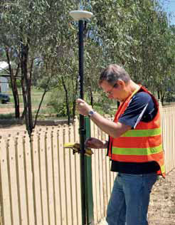
The first step in the project is to find all of the existing meters and record an accurate location so that they can find them again. To do this, Goulburn Valley Water equipped their meter reader field crew with Trimble® GeoExplorer® 2008 series GeoXH™ handhelds and Zephyr™ antennas mounted on rangepoles.
For the GIS data collection solution they turned to Thinking Windows, who with the help of the Trimble GPS Pathfinder® Tools Software Development Kit (SDK) produced an application named Aquire for Goulburn Valley Water.
The Aquire software was a tremendous success for Goulburn Valley Water. With it, the organization is now considering changing the meter reading process so that the meter reader picks up the location of the meter as well as the actual reading.
Satisfied with their meter location solution, Goulburn Valley Water is now contemplating other uses of high accuracy GIS data. The GPS Pathfinder Tools SDK is likely to be an integral part of any future solution, as it enables the simplification of data collection, allowing field crews to stay productive. “You never know when there’s something you’re going to need the location of” says Squires. He too, believes the GPS Pathfinder Tools SDK has been crucial to their success: “It’s the Swiss Army knife of GPS. It’s brilliant!” www.trimble.com |
|


 (2 votes, average: 3.00 out of 5)


Leave your response!