| Applications | |
Geospatial data sharing in Pakistan: Possibilities and problems
In Pakistan, immense geospatial data is available with various public and private sector organizations. Although, the Government of Pakistan (GoP) is funding public sector organizations to develop geospatial data, but at the same time, its role lacks in reducing redundancies in geospatial investments |
 |
|
 |
|
The problems in sharing of geospatial data among public sector organizations is a well established fact (Onsrud et. al., 1995; McLaughlin, 2003; Williamson et. al., 2004; Nebert, 2004; Masser, 2005; Georgiadou, 2006; Nama Raj Budhathoki and Zorica Nedovic-Budic, 2006; Rajabifard et. al., 2009). The reasons for non-sharing of the data cannot be exactly the same for developed and developing countries, though it may have some commonalities. For example, developed countries may face more institutional rather than technical problems, whereas the situation in some other countries may be the reverse, i.e., more technical and less institutional problems. A study carried out by Canadian Geospatial Data Infrastructure (CGDI) committee underscores quality, access and legal issues that hamper sharing of geospatial data, whereas unavailability of digital datasets, non existence of infrastructure, policies and standards, unavailability of skilled human resources and lack of funding impede data sharing in Uganda (GIC/ESRI Canada, 2011).
We argue that detailed and in-depth study is essentially required for finding out problems related to sharing of geospatial data for a specific country. Therefore, the main objective of this research is to investigate issues that impede sharing of geospatial data in Pakistan. Additionally, the research also explores possibilities for data sharing and proposes guidelines for its objective implementation.
Research methodology
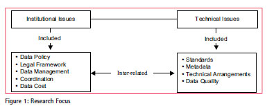
After critical review of literature, the case study method was selected for this research. A case study is an examination of the phenomenon in which the primary purpose of the observer is to carry out research rather than to implement a system or improve an operational environment (Onsrud et. al.,1992). It is an ideal methodology when a holistic and in-depth investigation is needed (Feagin et. al., 1991; Yin, 2003). Based on literature review and study carried out by Asmat (2008), a questionnaire comprising many technical and institutional issues was developed and distributed among various public and private sector organizations dealing with geospatial information. After getting the responses, the research was focused on only those technical and institutional issues that were pointed out by the majority of the respondents (Figure 1). Some brief interviews were also conducted telephonically as part of this research.
Geospatial data- Pakistani scenario
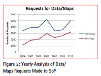
In Pakistan, immense geospatial data is available with various public and private sector organizations. The major part of this data is being produced by public sector organizations to facilitate their mandated responsibilities. These organizations are continuously busy in collecting, processing, updating and disseminating such data. People are increasingly accessing and using geographic map[s] and locationbased services, (Oxera report for Google, 2013). The demand for maps and geospatial data is growing in Pakistan too. For example, many public and private sector organizations, in addition to individuals, have approached the Survey of Pakistan (SoP) for provision of geospatial data. As a standard procedure adopted by SoP, each customer’s data/map request is documented. The analysis of these data/map requests indicates that almost every year the demand for geospatial data is growing (Figure 2).
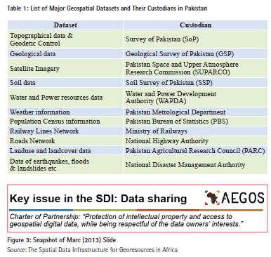
The public sector organizations that produce geospatial data include Survey of Pakistan (SoP), Pakistan Space and Upper Atmosphere Research Commission (SUPARCO), Pakistan Agricultural Research Council (PARC) and Census Department, etc. Table 1 displays list of major geospatial datasets and their custodians in Pakistan.
Geospatial data sharing in Pakistan – Problems and possibilities
The President of Pakistan has recently promulgated Surveying and Mapping Ordinance 2013, tabled by the Survey of Pakistan (SoP) that includes development of National Spatial Data Infrastructure (NSDI) for the country. SoP has been identified as the lead organization for the development of SDI at national level. But ‘SDI is an enabling platform that facilitates access to spatial data and sharing spatial resources’ (Rajabifard et. al., 2009). The focal concept of SDIs is sharing of geospatial data as asserts McLaughlin (2003), Williamson et. al., (2004), Nebert (2004), Masser (2005), Georgiadou (2006), Nama Raj Budhathoki and Zorica Nedovic-Budic (2006). Indeed, the focal concept of SDIs is data sharing, but at the same time data sharing is one of the key issues in SDI as argues Marc (2013) in a seminar at Brussels.
The sharing of geospatial data among public sector organizations is itself an issue (McLaughlin, 2003; de Montalvo, 2003; Radwan, 2004; Masser, 2005; Lance, 2006). Therefore, it is necessary to investigate issues related to data sharing and their possible solutions as a first step towards implementation of NSDI in Pakistan.
Institutional issues
Institutions are defined as ‘the rules of the game in a society or, more formally, institutions are the humanly devised constraints that shape human interactions’ (North, 1990). Institutional issues are always tackled with the help of constitutions, specific acts, laws, legislations, and regulations. These issues play a significant role in enabling sharing of geospatial data which is the crux of SDIs. Georgiadou et. al., (2005) finds that Indian NSDI failed at its early stage because of institutional issues. The detailed findings of this research about institutional issues related to geospatial data sharing in Pakistan have been elaborated later.
Data policy and legal framework
This research finds that the map policy has been one of the main reasons for hampering geospatial data sharing in Pakistan. The Survey of Pakistan (SoP) prepares the policy as SoP is legally mandated to collect, maintain and disseminate geospatial information of the country. To cope up with the ‘map mania era’, SoP prepared a comprehensive Surveying & Mapping Act which in principle supersedes the old map policy. The aforesaid Act has been recently promulgated by the President of Pakistan as Surveying & Mapping Ordinance 2013. Some of the salient features of the ordinance are:
• Various terms related with Surveying, Mapping, Geospatial Data, GIS, Geodesy and National Spatial Data Infrastructure (NSDI), etc., have been officially defined in the history of Pakistan. To avoid duplication of efforts in collection of the same datasets, sharing of data has been underscored.
• The value of data standards and specifications have been highlighted, and it has been made compulsory for all public as well as private sector organizations to produce standardized geospatial datasets for its effective and objective usage.
• The need to have inter-agency coordination for acquisition, processing, and maintenance of geospatial data, has been inked.
• The emerging need for development of National Spatial Data Infrastructure (NSDI) for Pakistan with the collaboration of all major stakeholders has been briefly outlined.
Indeed, the ordinance is a good mix of technical and non technical aspects for production, access, dissemination and sharing of geospatial data, but its implementation would be a challenge due to the prevailing organizational culture of the public sector in Pakistan.
Data management
The significant importance of data/ information management for governments can be noted from Obama Executive Order, 2013. In Pakistan, plenty of geospatial datasets are available with public and private sector organizations. The findings of this work indicate that most of the datasets are not properly managed and therefore are not ready for sharing. We argue that due to advancements in geospatial technologies, data is increasing in volume as well as in variety of formats, which has made data management a challenge. Data management is an institutional matter as can be noted from the Executive Order-Obama, (2013). Managing large volumes of datasets require sophisticated Data Storage (DS) and Archiving System (AS) as well as sufficient trained human resources. The storage of large amount of data is an issue, as finds Kevany (1995), – “Data storage can also become an issue for sharing because adequate storage capacity is required.” The cost of a data storage system is so high that no organization can meet its cost from the usual allocated annual budget. Survey of Pakistan was allocated special budget grant for procurement of data storage system with much efforts and lobbying.
Once the data storage system is in place, it is also important to have specially trained staff in the discipline of geospatial information management, as argues Onsrud and Rushton (1995), as well as de Montalvo (2003). Unfortunately, no such training facility is available in Pakistan.
Coordination
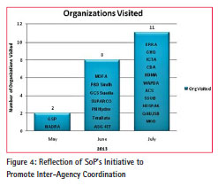
Most of the respondents of the questionnaire mentioned that lack of coordination among public sector organizations was the main reason for non-sharing of geospatial data in the country. Zahir (2013) noted that coordination among organizations is essential for data sharing in Pakistan. During an interview, Maj (R) Muhammad Tanvir, Director Map Publication, Survey of Pakistan underpinned this issue as the most significant problem in the context of sharing of geospatial data in the country. There is a degree of mistrust among data producer and data consumer organizations/users, he added. Katleen (2013) also highlights that trust is the main issue while dealing with sharing of geospatial data among organizations. Israel (1997) finds, “Nothing is more difficult in management than achieving coordination among different agencies. If institutional capacity is weak, coordination is practically impossible or perverse.” It is argued that mutual trust is the foundation for coordination. To win trust, it is essential to communicate and interact. It merits mentioning here that Survey of Pakistan is continuously interacting with various public and private sector organizations. Recently, more than 20 public and private sector organizations (Figure 4) have been visited by a delegation of SoP, headed by the Surveyor General of Pakistan. Visits to more sister organizations are also planned. The main objective of these visits is to promote inter-agency coordination for sharing of geospatial data in the context of NSDI implementation in Pakistan. To seek support from the international community for capacity building and technology adoption, a visit to the office of USAID and JICA in Pakistan is planned, too.
Data cost
All NMOs in the world are under pressure due to availability of almost free of cost geospatial data on the internet. Indeed, Google which is now also a mapping company instead of being just a search giant, is the major competitor of all NMOs. It is important to mention that data downloaded from the internet may not be ground verified, and therefore, accuracy as well as reliability of such datasets cannot be guaranteed (Asmat and Munir, 2012).
The findings of this study reveal that end users of geospatial data in Pakistan are reluctant to buy data due to its cost. But to revise the cost of data is beyond the full control of organizations. Ministries are also involved in setting the cost of such datasets. Hence, data cost is an institutional subject that limits data sharing in the country.
Technical issues
Many technical issues are barriers in sharing of geospatial data in Pakistan besides institutional issues mentioned earlier. However, majority of the questionnaire respondents pointed out standards, metadata, technical arrangements and data quality as the most significant. Therefore, these issues are addressed in detail, because without a comprehensive investigation of technical issues (Crompvoets et. al., 2008) a viable solution cannot be proposed.
Standards
The findings of this study divulge that most of the public sector organizations are producing geospatial data without adopting any standards, except Survey of Pakistan and SUPARCO. However, awareness about the importance of standards is rising in the country. For example, to mark the value of standards, a national conference was jointly arranged by Pakistan Bureau of Statistics (PBS) in collaboration with UNFPA and UN HABITAT. It was held in Islamabad in March 2013. The event highlighted not only the added value of geospatial data standards, policies and sharing of geospatial data, but also the urgent need to develop NSDI in the country. A large number of participants, including three-member delegation from SoP attended the conference. Some of the participants presented work done by their organizations in the subject of spatial discipline. All the participants appreciated the work done and presented by the Urban Unit. Qazi Ismatullah, Deputy Census Commissioner (G) PBS, Islamabad, efficiently coordinated with all the participants to make this event successful.
Metadata
The findings of the study disclose that the situation regarding creation of metadata is the worst in public sector organizations. One of interviewee stated, “We have not yet thought about metadata.” Presently, Survey of Pakistan (SoP) is the only public sector organization of the country that is producing standardized metadata. SoP has adopted ISO 19115:2003 Geographic Information – Metadata Standards. The creation of standardized metadata would give a jump start to NSDI implementation in the country. The standardized metadata prepared by Survey of Pakistan (SoP) enables other public and private sector organizations to harvest potential benefits of data collected by SoP and also to avoid duplication of efforts in collection of the same datasets.
Technical arrangements
Data sharing is the electronic transfer of data or information between two or more organizations as found by Calkins and Weatherbe (1995). In the context of this study, data sharing means sharing of geospatial data via wire. Therefore, to enable geospatial data sharing practically, lots of technical arrangements such as availability of secure Local Area Network(LAN)/Wide Area Network (WAN), Portals, Web Servers, online data transaction system and high speed broadband internet service, etc., are a prerequisite. The study investigated these arrangements in a detailed manner which is served next.
Backbone network infrastructure
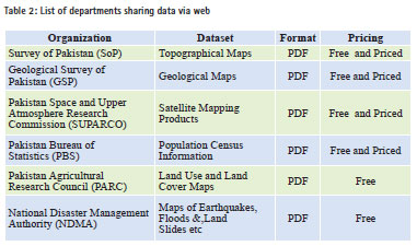
Backbone network infrastructure means a medium, i.e., LAN, WAN and Internet arrangements to actually transfer data between two locations. In Pakistan, such arrangements in the form of centralized or distributed networks do not exist among public sector organizations. However, there are few individual efforts made by some departments to share data via the internet. The details of such departments, their datasets and the format of data being shared are tabulated as Table 2.
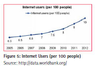
There is an emergent need to establish such networks for geospatial data sharing. To start with, lessons can be learned from PERN (Pakistan Education & Research Network) that has now upgraded to PERN 2 as NREN (National Research & Education Network of Pakistan). The network has evolved significantly and is providing valuable services, like highspeed internet, audio/video conferencing, and access to digital library resources. Besides implementation of network infrastructure, there is an equal importance of existence of internet users to get benefits from such networks. The study has, however, witnessed growth in internet users in Pakistan as portrayed in Figure 5.
Geospatial imagery is regarded as fundamental dataset. But it possesses large volume. Therefore, to share this type of geospatial data quickly and efficiently, the need to have broadband internet service cannot be denied. Significant improvement in this context is also evident from data collected by the World Bank.
Presently, many public sector organizations are not equipped with these interconnecting technologies, such as high speed internet and fully established LAN/WAN, therefore making sharing of geospatial data impossible.
Portal
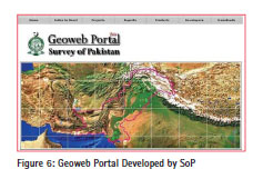
In Pakistan, geoportals are not yet developed by all public sector organizations to share data. Survey of Pakistan (SoP) has developed a geoportal which is accessiblethrough LAN (Figure 6).
Security concerns
In Pakistan, security of cyber space is at high node as identified by Shahid Nadeem (2011). According to the study, many organizations prefer not to share data online due to the challenge of information security. However, studies conducted by World Bank finds that number of secured internet servers in the country have been increasing over the past years. Despite this, information security is one of the main reasons that hamper sharing of geospatial data in Pakistan.
Data quality
This study reveals that fear of exposure of poor data quality is one of the technical reasons that impede data sharing in Pakistan. To ensure production of good quality data, it is essential to make data quality control arrangements comprising skilled manpower as well as latest and state-of-the-art geospatial tools and technologies. Public sector organizations were questioned about Data Quality Control (QC) arrangements. Except, Survey of Pakistan (SoP), no such arrangements were found visible by any other public sector organization.
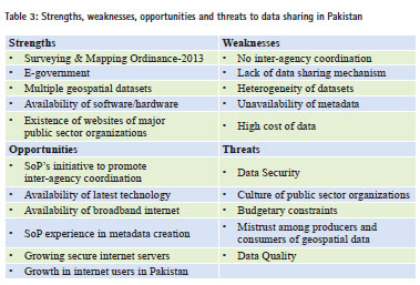
From the above discussions a lot can be learnt about the problems that hamper sharing of geospatial data in Pakistan. This study also identified possibilities for sharing of the data in the country, in addition to presenting some guidelines for their implementation. The findings of this study are summarized as SWOT Analysis in Table 3.
Conclusions and future work
In Pakistan, geospatial data is not being shared due to various institutional and technical problems. The findings of this study reveal that the institutional issues include; lack of data policy and legal framework, data management, lack of coordination among organizations and relatively high cost of the data itself. Whereas, technical issues that contribute towards non-sharing of the data are absence of data standards, nonavailability of metadata and nonexistence of infrastructural arrangements as well as fear of exposure to data quality. Technical issues can be resolved with the assistance of international agencies such as GSDI, FGDC and JICA as these agencies are providing technical as well as financial support to implement data sharing related projects in many developing countries. However, one of the hardest problems in sharing of the data is lack of coordination among organizations, which money can’t buy. Therefore, Government of Pakistan should come forward and enable a conducive environment for promoting coordination, collaborations and collations among public sector organizations especially by introducing and implementing requisite supportive policies.
This study reveals that a number of activities have taken place in the country that can contribute towards data sharing arrangements. The most significant is the recent promulgation of Surveying and Mapping Ordinance-2013. Some of the other possibilities include; SoP’s initiative to promote inter-agency coordination and development of standardized metadata as well as data quality control arrangements, growing awareness about NSDI, growth in secure internet servers, availability of broadband internet, existence of websites of major public sector organizations and Pakistan’s E-Government program, etc.
NSDI is a relatively new concept not only for Pakistan but also for most of the other developing countries. Moreover, there is no blue print available for its implementation. Therefore, efforts should be made to learn from the experience of other countries that have implemented SDIs at national level such as UK, Canada, USA and China, to initiate in the right direction and implement successfully NSDI in Pakistan, as well. An in-depth study as future work is recommended to identify other issues, which could not be addressed in the current research such as political, economical and cultural etc that impede sharing of geospatial data in the country.
The paper was presented at GSDI 14, Addis Ababa during November 4-8, 2013.


 (2 votes, average: 3.00 out of 5)


Leave your response!