| His Coordinates, Interviews | |
Ease of operations and low-cost of UAS will allow democratization of aerial imagery
 |
|
“SimActive is the pioneer of the new mapping era offering cutting-edge photogrammetry software”. Please elaborate.
When SimActive started the development of its Correlator3D™ software back in 2003, the capability to rapidly gather vast amounts of imagery was quickly becoming the bottleneck in geospatial data production. Since then, the use of medium and large format aerial systems, satellite sensors and consumer grade cameras mounted on UAV platforms has exploded. Hence, there has been a growing requirement for photogrammetric software tools able to handle thousands of frames from any kind of imaging system.
SimActive has been the first company to introduce the use of graphics processing units (GPUs) to generate digital surface models (DSMs) and a new technology for producing ultra large orthomosaics with no limit to the number of images. The company is also the first and only provider to offer an aerial triangulation (AT) module based on GPUs, bringing the fastest commercial tool for that purpose.
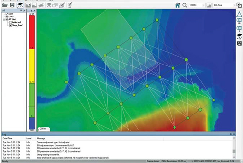
Describe the features of latest version 5.0 of the Correlator3D™ software?
With the release of version 5.0, Correlator3D™ brings a unique approach for visualizing AT results. This allows for a quick assessment of quality, including the capability to see links between adjacent images after tie point extraction as well as bundle adjustment residuals. Although these concepts are quite abstract and hence difficult to visually represent, the software produces a view that allows quick and intuitive inspection of results. Furthermore, the software’s digital terrain model (DTM) extraction module was completely redesigned, leading to better results and significantly faster processing times.
How is Correlator3D™ software better than other competitors in the market?
Correlator3D™ innovative design enables processing an unlimited number of images – multi terabyte data – empowering users to tackle any project with confidence. To process larger projects with ever increasing frame size, the intelligent use of GPUs and multi-core CPUs was introduced providing a significant boost to traditional CPU or ad-hoc GPU solutions. This allows even the highest density DSMs and DTMs to be produced for a full project within only a couple of days. The software also features a special structure developed for handling orthomosaics, called mosaic fragmentation. This innovative design not only makes it possible to process limitless number of images, but also allows for limitless users to simultaneously edit a mosaic without conflicts or duplication of any data.
What are the different application areas Correlator3D™ software could become an ideal choice for your customer?
Correlator3D™ allows processing of data from traditional medium / large format aerial cameras, satellite sensors and any consumer grade camera such as those found on UAV platforms. This is a big advantage as the same photogrammetry tool can be used on any kind of data, in the exact same production workflow. Photogrammetry experts can produce high accuracy results and rapidly map large areas using aerial cameras as well as satellite data. UAV users can also benefit from a simple-to-use software that allows to bring the precision of traditional photogrammetry to UAV mapping.
What are the main R&D considerations while developing the software?
Significant R&D efforts went into bringing intelligence into the software, alleviating the need for specialized photogrammetry knowledge. This means the software is accessible to all users regardless of their experience or knowledge level. This is especially useful when new personnel are coming on board or when a high turnaround of users is present, and ends up saving companies time and money. With simple self-explanatory windows and modules that naturally flow into one another, an intuitive workflow promotes a high level of automation and robustness by design. Thus, precise geospatial products are generated in an efficient and simple manner.
With the advent of UAV, how do you see the evolution of photogrammetry?
There are multiple operational advantages associated with UAVs, such as quick deployment and associated low costs. From their ability to fly at low altitudes, they usually also collect imagery at much higher resolutions (e.g. 1cm ground sample distance). However, the drawback is that they can cover only small areas and the quality of images is generally poorer than their large-format counterparts. Photogrammetry software solutions therefore need to be highly robust to be able to handle such data and still produce high quality results. Because of the drawbacks associated with UAVs, any large scale production project, such as that to map cities, counties or other large areas will still continue to require large-format cameras and satellite data.
What are the challenges associated with the imagery acquired using a UAV?
UAV imagery is typically collected within a couple of hours. Such a collection rate necessitates a need for quick image processing, with the expected time to be generally within the same day or week. This is quite a difference from traditional photogrammetry, where processing can be spread over a few months. Other challenges include the ability to cope with inconsistent overlap between images. Traditional survey systems ensure constant overlap between successive images, while UAVs produce widely varying data, complicating the photogrammetry problem. In conjunction with the varying overlap, the radiometry within a UAV project (color across different images) also varies significantly, making the mosaic creation process significantly more difficult.
How do you see the growth potential of UAV/UAS market in the years to come?
The number of UAVs worldwide has exploded in the last couple of years and will keep growing rapidly. The operational advantages as well as low-cost of these systems will allow a democratization of aerial imagery and associated geospatial data. New applications are developing around UAV mapping, such as periodic monitoring of areas (e.g. mine pits), as they allow quick and cheap up-todate data. Photogrammetry software will thus need to the pace and meet continually changing requirements

Testimonial
“We were impressed with thesoftware’s capability and processingtimes. The results achieved were notonly produced quickly, but with a highdegree of accuracy”- Mr. Mohamad El Kadi, Managing Director of Space Imaging Middle East


 (27 votes, average: 1.93 out of 5)


Leave your response!