| Perspective | |
Cadastre in a Changing World: Issues and directions
Experts discuss the issues and the directions in cadastre in a changing scenario |
A well-tailored cadastral system is in fact acting as a backbone in society
 |
|
In most countries, the cadastral system is just taken for granted, and the impact of the system in terms of facilitating an efficient land market and supporting effective land-use administration is often not fully recognised. The reality is that the impact of a well-functioning cadastral system can hardly be overestimated. A well-tailored cadastral system is in fact acting as a backbone in society. The Peruvian economist Hernando de Soto has put it this way: “Civilized living in market economies is not simply due to greater prosperity – but to the order that formalized property rights bring”. The point is that the cadastral system provides security of property rights. The cadastral systems thereby paves the way for prosperity – provided that basic land policies are implemented to govern the land sensitive to contextual and cultural issues, and provided that sound institutions are in place to secure good governance of all issues related to land and property.
Evolution of cadastral systems
The human kind to land relationship is dynamic and is changing over time as a response to general trends in societal development. In the same way, the role of the cadastral systems is changing over time, as the systems underpin these societal development trends. Over the last few decades land is increasingly seen as a community scarce resource. The role of the cadastral systems has then evolved to be serving the need for comprehensive information regarding the combination of property rights, valuation and taxation, and planning and control of the use of land. New information technology provides the basis for this evolution. This forms the new role of the cadastral systems: the multi-purpose cadastre.
The UN-ECE Guidelines on Land Administration (UN-ECE 1996) was sensitive to there being too many strongly hold views in Europe of what constituted a cadastre. Another term was needed to describe these land-related activities. It was recognized that initiatives that primarily focused on improving the operation of land markets had to take a broader perspective to include land-use planning as well as land tax and valuation issues. As a result, the publication replaced “cadastre” with the term “land administration” that is now regarded as “an enabling infrastructure for implementing land policies and land management strategies in support of sustainable development” (Williamson, et.al. 2010).
The term “Land Governance” emerged in the late 2000s as a more holistic term covering the policies, processes and institutions by which land, property and natural resources are managed. This includes decisions on access to land, land rights, land use, and land development. Land administration is then the operational component of land governance.
Future directions
In the Western cultures it would be hard to imagine a society without having property rights as a basic driver for development and economic growth. Property is not only an economic asset. Secure property rights provide a sense of identity and belonging that goes far beyond and underpins the values of democracy and human freedom. Therefore, property rights are normally managed well in modern economies where cadastral information provides the basic layer of interactive land information systems in support of building spatially enabled societies (FIG pub. no. 58).
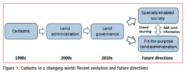
In contrast, most developing countries have a cadastral coverage of less than 30 per cent of the country. The cadastral systems normally operate with western procedures for cadastral surveys and the systems do not recognise the range of more informal or customary types of tenure. In these countries there is a need for a more flexible and “fit-for-purpose” approach to building adequate cadastral systems. The term “fit-for-purpose” indicates that the systems should focus on the citizens´ needs, such as providing security of tenure and control of land use, rather the focusing on top-end technical solutions and high accuracy surveys. The systems can then be upgraded over time in response to societal needs and available resources. The Western style systems may well be seen as the end target, but not as the point of entry. (FIG pub. no. 60).
Furthermore, the spatial information revolution, through platforms such as Google Earth, has raised discussion around the use of crowd-sourcing for data collection and, on the other hand discussions about the need for data to be Accurate, Assured, and Authoritative (AAA). These discussions are driven by technology development that enables push-button access to a variety of data from various sources.
Closing remarks
Cadastral systems are normally understood as a parcel based and up-todate land information system containing identification of the individual land parcels and a record of interests in land such as land ownership. The evolution of cadastral systems now points at two different future directions towards building spatially enabled societies (developed countries) and towards building basic fitfor- purpose land administration systems (developing countries). Importantly, the role of the cadastral systems is seen as the core component within both directions which are both impacted by the discussions around crowd sourcing as well as the quest for AAA land Information (FIG pub. no. 61).
Further readings
FIG publications Spatially Enabled Society, FIG Pub. no 58; Fit-for-Purpose Land Administration, FIG pub. no 60; Cadastre 2014 and beyond, FIG Pub. no 61. See FIG publications: http:// www.fig.net/pub/figpub/index.htm.
Williamson, Enemark, Wallace, Rajabifard (2010): Land Administration for Sustainable Development. ESRI Press. http://www.esri.com/landingpages/ industries/land-administration/ebook# sthash.Lp4BYcKW.xlJsrwte.dpbs
The need for fast, cheap and good land administration
 |
|
Estimations show that about 70% of the people-land relationships are not documented. This while population grows and the pressure on land and natural resources increases. Also in countries where (some level of) land administration is in place, the technological push and the evolving societal demand ask for continuous development of land administration systems. Appropriate administration of land is the start for conflict resolution, sustainable development and land use planning anywhere in the world. No time should be lost starting this important work.
The key question is: can we register the relevant people-land relations world wide within one generation? Or do we accept that this will take many more centuries, sticking to our present paradigms, methods, capacity and business models?
The introduction of Fit for Purpose Land Administration can be considered a new way of thinking in achieving faster, cheaper and more appropriate land administration systems for the world. The approach has been presented in FIG publication no 60 and guidance for the application is under development within the GLTN partner network. The key-principal is that land administration should be developed in such a way, that it is appropriate to the needs of society.
Appropriate land administration can be defined by four aspects. First of all, the requirements of users (or citizens) should be the starting point, not the professional or technological standards. Fortunately, standards like the Land Administration Domain Model (LADM) and software like STDM or FLOSOLA exist and do help very much in getting systems in place. After the user requirements, three other important aspects should be in place: The quality of the data and systems (good), the acceptable timeframe to collect and register the data (fast) and the price of development and maintenance of the system (cheap).
In our present solutions we are thinking in the paradigm of making choices; Good and fast land administration won’t be cheap, fast and cheap land administration won’t be good and cheap and good land administration won’t be fast. It is the challenge to abandon this mindset and to develop a new paradigm where cheap, good and fast go together.
Boosting land administration is becoming also a concern outside the professional world of surveyors and land administration specialists. The developments at UNGGIM (Global Geospatial Information Management) has become a good example of this. The world of statistics has encountered the geospatial world. And even the Remote Sensing world and the Land Administration world are joining in now. Four different professional groups, four different languages, converge for the benefit of all, including the need for appropriate land administration.
Recognizing the need for global registration of land rights, different organisations and professionals start acting and show leadership. UN FAO has developed the Voluntary Guidelines, UNHabitat takes up the need for practical tools with it’s GLTN program. The World Bank started monitoring good practices in the land sector with a land governance Assessment Framework (LGAF). Together with FIG, they also promote Fit for Purpose Land Administration approaches.
The information technology as such, will continue to develop with respect to technology, size and protocols. It goes without saying that technology will be a driving force for making good, fast and cheap land administration systems happen. The development of software, both commercial and open source, is in full progress. Social media will fill in new communication possibilities and (consumer) hardware will keep on boosting the possibilities.
Capacity building will remain a concern for the near future. Are we able to develop a professional arena of sufficient size, in which people are willing to set the user demands central and change the paradigm to thinking in good AND fast AND cheap?
Finally, good public private partnership will help in meeting the objectives. However, essential roles for both private and public organisations will continue to exist (likewise, this goes for scientific organisations and NGO’s). The private sector is developing user-centric approaches, while governments will focus on citizens, being citizen-centric. And no confusion should exists. Users are people who can potentially pay for a service or product of a company. Citizens are people that rely on their government, representing them. These are two different things. Both need attention, but they shouldn’t be confused. It is also the reason that both private and public bodies will continue to be needed in the future.
Good, fast and cheap land administration must be achieved for the next generation. This can be done by mobilizing leadership and by stimulating international cooperation, innovation of methods and the adaptation of modern technologies. These are essential parts of the cadastral actions needed and can no longer be achieved by one professional sector alone.
Is complacency the biggest threat to modern cadastres?
Today is an exciting time for cadastral reform
 |
|
In the developed world the majority of cadastral systems are complete with digital cadastral maps covering all land parcels linked in real time to land titles, land values and planning information. Importantly the parcels are linked to street addresses. Collectively this enables and underpins the spatial enablement of government and wider society in almost every aspect of human endeavor, from the support of land markets to environmental management, policing, recreation and emergency response to name a few.
At the same time we see the growth of 3D cadastres that are supporting the development of smart cities and vertical villages. Marine cadastres are also developing with the extremely sensitive coastal zone being better managed and integrated across the land-sea interface. The digital revolution, positioning technologies, smart phones and sensors all combine with and leverage off spatial enablement and the cadastre.
In the less developed world access to land, shelter, security of tenure, land markets and gender equity are just as urgent. The World Bank, the United Nations, NGOs like the FIG, and governments and academics are continually exploring more efficient and effective ways to manage land, provide land governance and develop systems that are affordable and fit for purpose.
While there are many challenges ahead, it is an exciting time indeed.
Many countries are looking to the future at how their cadastres can develop to better meet the needs of society. A good example is Australia where the Intergovernmental Committee on Surveying and Mapping (ICSM) has just released a national cadastral reform and innovation strategy titled CADASTRE 2034 (http://www. icsm.gov.au/cadastral/index.html#nscri). The vision is a cadastral system that enables people to readily and confidently identify the location and extent of all rights, restrictions and responsibilities related to land and real property.
Cadastre 2034 has five goals. Their purpose is to achieve a cadastral system that:
1. is fundamental to land and property ownership and is sustainably managed;
2. is truly accessible, easily visualized, and readily understood and used;
3. is fully integrated with broader legal and social interest on land;
4. provides a digital representation of the real world that is survey accurate, 3-dimensional and dynamic; and
5. is a federated cadastral system based on common standards.
An important strength of Cadastre 2034 is the recognition of the basics. All too often aspects such as the survey marks, cadastral plans, the legal framework, standards and registered surveyors are overlooked.
The Australian cadastral system plays a critically important role in the economic and social prosperity of the country. As stated in the strategy, at the end of 2014, there were $1.4 trillion in housing loans secured against land titles. At the same time the total value of all real property held in title in Australia is estimated as $5.2 trillion. The importance of the cadastral system is self evident given that the size of the Australian economy is $1.6 trillion (as at November, 2014).
However a problem of one and a half Centuries of cadastral endeavor, where excellent systems have been built and operate across Australia’s states and territories, is that the system works so well. There is an ongoing challenge to convince our political masters that the cadastral system needs ongoing attention and improvement. It is not uncommon for them to question why we should spend funds to fix something that works!
There have been recent cases in Australia where government has seen the cadastre and title registration as a “cash cow” ripe for privatization without government oversight and management – a very high risk strategy. While some governments have been supportive of research and development in the cadastral area, it is becoming increasingly difficult to convince them of the need for an ongoing commitment.
At the higher education level we have seen a reduction over the years in the emphasis on cadastral and land administration issues in university degrees. This is not only an Australian phenomenon, but an international trend with university programs that historically educated professional land surveyors reducing their commitment or even ceasing to exist. This undermines the capacity of countries to design, build and manage the modern cadastres needed for the decades ahead.
So I pose the question that the biggest threat to modern, efficient and effective cadastres is complacency. In fact it is remarkable how well the current cadastral systems have evolved in the developed world at a time when the political commitment to them appears to be reducing at both a government and educational level.
I don’t know the solution to complacency, however I applaud the Turkish Government for sponsoring The World Cadastre Summit as an important step in the right direction. Let us make the most of this event to ensure our future cadastres continue to evolve to serve the needs of an ever changing society.
GIS simplifies cadastre management
 |
|
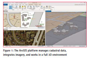
Cadastral systems don’t have to be expensive and complex. Esri pioneered a technology platform that’s open, simple to set up, and easy to support. Being built on open standards, it simplifies integration with other systems and makes powerful use of configurable apps and web maps—in particular, commercial-offthe- shelf (COTS) software. With ArcGIS COTS solutions, you configure your cadastral data collection, management, and sharing needs with supported, proven technology instead of customizing costly, difficult-to-maintain systems. ArcGIS gives you access to new technology without the need for software coding and updating custom or thirdparty software with each new release. This is a much more immediate solution than a custom-built system fraught with protracted workflows. A sensible cadastral system provides new tools, authoritative data, and fast deployment technology as it becomes available. ArcGIS essentially future-proofs your cadastral system with a secure, scalable, and sustainable platform.
Complete vs. Cobbled Together
ArcGIS is a unified platform for cadastral systems that supports surveying and data collection, recording rights and restrictions, digitizing documents from antiquated paper systems, and indexing information in modern spatial conventions. It integrates authoritative basemaps and high-quality satellite imagery and also provides comprehensive sharing technology to make the best use of those map and imagery resources. Importantly, it includes COTS apps and tools that only require light configuration to meet your agency-specific needs.
Light Configuration vs. Heavy Coding
Hardcoding systems limits the ability for a cadastral system to evolve. Why? With new technological capabilities being released every day, custom hardcoded systems can’t take advantage of the latest technology and are extremely difficult to maintain—particularly with limited advanced technical skills. Configuring supported, feature-rich technology instead of coding eliminates the constant need for skilled technicians and hardens your system for the future.
Security vs. Vulnerability
Security is a challenge with customdeveloped systems. Since cadastral systems are essentially banking systems for land, they require rigorous security for user/role authentication to maintain data accuracy, consistency, and system integrity. Esri more than meets those stringent security requirements. ArcGIS is certified to the highest independent, international, and industry-accepted privacy standards, including TRUSTe Certified Privacy Seal and EU Safe Harbor.
Connect vs Collect
In the past, cadastral surveyors created basemaps, downloaded satellite imagery, and built data sets that duplicated the mapping efforts of other organizations. With cloud technology (and, yes, cloud operations can work disconnected in challenging environments) and web services, modern, low-cost, fast-to-deploy systems connect to the data you need. This means that you no longer have to commit time and labor to building storage and management infrastructure for imagery, basemaps, and other common data layers. It’s all consumable now from the office to the field.
Cohesive Platform vs. Disparate Applications
Many cadastral systems have been developed with customized implementations of disparate applications and technology. These individual applications have different update cycles, data requirements, require custom security measures and specific and often difficult-to-find support. Today, sustainable systems are configured (not custom developed) on a scalable, secure, complete COTS platform. Building sustainable cadastral systems requires proper design that allows for evolving technology, requirements, and data. Cadastral systems built without consideration of emerging new user requirements, evolving legal structures, and rapidly advancing technologies are less effective and have a limited lifespan. ArcGIS provides the platform for low-cost, easy-to-implement tools that all resilient cadastral systems require.
Why and what to standardize in Land Administration?
 |
|
 |
|
Sustainable development, human rights or spatial planning: they are difficult to achieve without proper land administration. Land administration provides documentation that indicates the relationship between people and land. Land professionals know that a big majority of these peopleto- land-relationships worldwide is not documented. This often results in uncontrolled development, land degradation, forced evictions, land disputes, conflicts and land grabbing. Apart from tenure insecurity the government can not fairly generate income from land taxation.
Need for land administration
Land administration systems are worldwide recognised as being important for governance. Governments need information to govern. Accessible information on ‘people to land relationships’ is crucial here; for sustainable economic and infrastructural development and interrelated spatial planning, for resource and environmental management, for disaster management. All this is about today’s challenges as change in climate, problems with draught and access to water, unequal access to land and lacking social justice, food shortage and a growing urban population with a complex urban–rural interface.
Knowledge is fragmented
In many countries the responsibilities and tasks in land administration are distributed among different organisations. Sometimes those organisations deal with different administrative territories. All of which may have subdivisions again: central, regional and local responsibilities, with either public or private roles. As a result, the governance and quality aspects of the data sets vary. Land administrations worldwide are often incomplete, data are not up-todate and not fit for purpose. At the same time, new Land Administration Systems (LASs) are being developed all over the world again and again. Sometimes countries even have more than one IT-system for land administration. The wheel keeps being re-invented. This has a huge impact on the continuity and effect of LASs.
ISO 1952
Just like social issues benefit from proper land administration, land administration systems themselves benefit from proper data standards. After more than a decade of development, within first FIG and next ISO TC211, the land administration domain model (LADM) was accepted in 2012 as an international standard ISO 19152.
Both paper-based systems and computerised systems require standards to identify elements. In existing land administrations and land registries, standardisation is generally limited to the region or jurisdiction where the land administration is in operation. A flexible (generic) system as LADM, concerns a elaborate standardisation. It does not only define the elements that provide a basis for any land administration set-up; it also defines them in such a way that it can be applied anywhere in the world.
Motivation
The generic benefits of standards are in bringing parts together: meaningful exchange of data and building the future Spatial Data Infrastructure (SDI). This is about standardization as a condition for interoperability between the organisations responsible for the land data (land registry, cadastre, land taxation organisations, etc), the data providers (surveyors, conveyors, land professionals) and the users of the data (citizens, governments, companies, banks). Standardization enhances quality when based on knowledge and experience of the global community of professionals. And it increases effectiveness because components do fit better in industry+open source solutions.
The land administration standardization includes the alignment to ISO 19000 series of standards: earlier TC211 standardizes domain neutral: basics for geometry, topology, temporal aspects, reference systems, metadata, and more. Based on these TC211 standards both commercial and open source software has been developed for processing survey data, geo-DBMS, GIS, geo-webservices, etc. The LADM therefore allows efficient design/development of ICT systems.
What is included in LADM
First of all it is a reference domain model, covering basic information-related components of land administration. This means an abstract, conceptual model that includes information sets for:
1. parties (persons and organisations); a broad and extensible range of parties can be included,
2. basic administrative units, rights, responsibilities and restrictions (e.g. ownership and use rights), this concerns the implementation of the continuum of land rights from UNHabitat and of the voluntary guidelines on the responsible governance of tenure of land fisheries and forests from FAO,
3. spatial units (e.g. parcels and the legal space of buildings and utility networks), including a subset for spatial sources (surveying) and spatial representations (geometry and topology). Again a very broad range of functionality is supported here: from point cadastre to 3D cadastre.
The LADM provides a uniform terminology for land administration, based on various national and international systems, that is as simple as possible in order to be useful in practice. The terminology allows a shared description of different formal or informal practices and procedures in various jurisdictions. LADM is the basis for development of national & regional profiles (application schemas).
Flexibility
It should be noted in relation to this that this that the functionality for implementation is very flexible. For example:
– An administration for customary tenure (in order to protect against ‘external threats’ as land grabbing): group person type, customary right type, spatial unit type with fuzzy boundaries
– An point cadastre in a slum area in order to improve services: natural person type, informal right type, point spatial unit type
– A conventional parcel based land administration in a residential area (taxation, tenure security): (non) natural person type, ownership right type, parcels type
– 3D Cadastre in business area: (non) natural person type, ownership holding, volume spatial unit type
– State lands: government person type, state land right type, set of lines spatial unit type
Conclusions
LADM is based on collective experience of experts from many countries and the International Federation of Surveyors. The model covers complete land administration spectrum: survey, cadastral maps, rights, restrictions, responsibilities, mortgages, persons, etc. The focus is on information, not on process/organization aspects, this is too country specific. LADM is modular (packages) and extensible and allows integrated 2D and 3D representation of spatial units. Formal, customary and informal rights are supported. LADM links essential land information data to source documents, both spatial (survey) and legal (title, deed).
Cadastre in a Changing World: A UN-GGIM Perspective
 |
|
 |
|
It is widely acknowledged that land, including rights and ownership, plays an important role in promoting economic development, social inclusion and poverty reduction. However, significant land challenges still exist in our changing world, particularly in developing countries. As stated by the Dutch delegation during the Fourth Session of the Committee of Experts on UN-GGIM in August 2014: “For an estimated 70% of the world population there is no registration of land – property relations. … Good land administration, considering both formal and informal rights of the use and ownership of land, is a basic requirement for social and economic development”. Based on this statement and a number of interventions and discussions on ‘land’, the UN-GGIM Committee of Experts approved its addition as a new work item.
As many will know, the UN-GGIM Committee of Experts was established by the United Nations Economic and Social Council (ECOSOC) in July 2011 as a formal inter-governmental mechanism, and consists of senior national Government representatives from Member States; the majority of which have responsibilities for geospatial information and land management. The Committee is mandated, among other tasks, to provide a platform for the development of effective strategies on how to build and strengthen national capacity on geospatial information management, as well as disseminating best practices and experiences related to legal instruments, management models and technical standards.
So, why is UN-GGIM focussing on land administration and management? Land is the single greatest resource in most countries. Land administration is an important component of the infrastructure for an efficient economy, which means that it touches all aspects of people’s lives. Increasingly decision makers have come to recognise the value and importance of land information (by extension the cadastre, parcel information, ownership, valuation and related information – land use etc.) as a fundamental component to attaining sustainable development objectives of, economic development, social justice, environmental management and good governance. This has been fuelled by the ability to integrate disparate datasets and leverage data analysis across various functional areas and business processes using geospatial and information systems technologies. Furthermore, land will provide a number of critical inputs into the implementation of the Sustainable Development Goals (SDGs) currently being discussed and determined by the United Nations General Assembly in New York. The ability to measure and monitor the targets and indicators of the SDGs over time will require reliable and enduring data on land and its relationship with people and the environment.
The challenge is to define the extent of UN-GGIM participation in this large area of land management work, particularly given the organisations that are currently successfully working in the field and the need to avoid duplication of effort. UNGGIM’s niche is to be able to provide the appropriate policy context and the support for geospatial information management, more broadly, and land administration more specifically, to Member States as an important enabler for economic growth and sustainable development. UN-GGIM has the ability to collectively advocate for increased global awareness of the need for the collection and maintenance of comprehensive, current and credible land information; in addition to encouraging good land governance inclusive of the creation and use of applicable land polices and legal arrangements, and the adoption of appropriate enabling technologies, standards and best practices.
The UN-GGIM agenda item ‘Application of geospatial information – land administration and management’ is being advanced with the preparation of a discussion paper to be presented with a covering report to the Committee of Experts in August 2015. The paper will be a collaborative effort with international partners including: FIG, World Bank and United Nations bodies such as Habitat, and will detail: the current challenges impacting land administration and management and the specific issues to be addressed by the Committee of Experts.
The inclusive and expansive character of UN-GGIM provides the platform that enables interaction with, and among leaders across the World, who are able to articulate the benefits an effective and efficient land administration system can make to their country. Rwanda has been undertaking a very large land regularisation project and it is an example to us all how in five years, a difference can be made to everyone in the country. As HE Ambassador Protais Mitali, Ambassador of Rwanda to Ethiopia and Permanent Representative to the African Union said ‘“Rwanda has created an electronic land registry which is known as the Land Administration Information System (LAIS). The Electronic Land Registry now has been connected to all banks to ease the process of getting loans using the land as collateral. The electronic registry also clearly increased transparency about land ownership and has reduced fraud”
The cadastre remains increasingly relevant as a fundamental data theme that underpins and supports a plethora of developmental operations relevant to a country’s economy. The mission is therfore for global players to work together to encourage and support Member States to employ fit for purpose policies, strategies, technologies, methodologies and practices for the good governance, management, monitoring and maintenance of its land assets.


 (249 votes, average: 1.10 out of 5)


This came out of the Cadastral Summit in Istanbul in April 2015. Last time I checked, Ms. Lawrence was not a cadastral or land administration expert. She was into publishing before joining Ordnance Survey in 2000. Ordnance survey is also not a cadastral organization.
Publishers of Coordinates, please get your facts right on whom you list as experts in cadastre. Ms Lawrence is most definitely not. It detracts from what is otherwise not a bad article.
Leave your response!