|
|
|
|
|
 |
|
|
RMSI ranked the ‘Best Workplace’ across all industries in India
RMSI has been ranked first in the Top 25 Great Places to Work in India by a study conducted by the Great Place to Work® Institute, US, along with The Economic Times, a financial daily in India. RMSI provides geospatial services, consulting to application development to spatial analysis and modeling to remote sensing and data conversion. www.rmsi.com |
|
|
28th Annual ESRI International User Conference explores Geography in Action
This summer, more than 14,000 professionals from more than 120 countries will experience the paramount event of the year for the ESRI software user community, the ESRI International User Conference to be held August 4–8, 2008, at the San Diego Convention Center in California. Regardless of their industry or level of experience with GIS technology, all ESRI GIS users are encouraged to attend this enlightening and inspiring forum designed around the theme GIS: Geography in Action. www.esri.com
|
|
|
|
Trimble news
Trimble has introduced a software package to continuously monitor and control DGPS broadcast sites for marine navigation – Trimble® Coastal Center™. It provide network operators the ability to monitor and control multiple DGPS beacon stations from one central location, saving time by automating functions and tasks remotely.
Trimble has also introduced the Trimble® NetR3™ GNSS reference sensor. It seamlessly integrate into any Trimble Virtual Reference Station network or other infrastructure application, for tracking and streaming data.
Trimble has also been chosen by Croatian Ministry of Finance to supply 31 Trimble® NetR5™ Reference Stations, 31 Trimble Zephyr Geodetic™ antennas and Trimble VRS™ (Virtual Reference Station) technology to establish a nationwide GNSS infrastructure network. www.trimble.com. |
|
|
Leica IPAS20 and MobileMatriX v3.0
The new Leica IPAS20 system delivers direct georeferencing for a wide range of airborne sensors such as imaging, LIDAR, SAR, thermal and multispectral systems. It is equipped with GPS/GLONASS technology and a plug and play IMU interface.
Leica Geosystems has also released Leica MobileMatriX v3.0. It offers the ability to synchronize survey data with an enterprise geodatabase, transfer digital images taken from a mobile phone via Bluetooth and link it with a feature. www.leica-geosystems.com |
|
|
Blue Marble gets Company of the Year award
Blue Marble Geographics were honored with the Governor’s Award for Technology Company of the Year at the TechMaine Technology Awards Showcase on May 20, 2008. It is for success in creating a financially stable, cutting edge business that supports the people of Maine by providing skilled technology jobs. www.bluemarblegeo.com |
|
|
CalAmp implements u-blox 5 across MRM products
CalAmp Corp. unveiled a series of mobile resource management products built around u-blox’s GPS platform. The u-blox 5 contains a 50-channel GPS receiver and features more than 1 million correlators and separate acquisition and tracking engines, capable of massively parallel searches. It can achieve -160 dBm acquisition and tracking sensitivity. www.u-blox.com |
|
|
Pendulum rolls out GPS/ GLONAS frequency standard
Sweden’s Pendulum Instruments has released GPS and GLONASS controlled frequency standard dubbed GPS-12RG. The reference and calibration instrument is based on this standard, which contains a high-stability rubidium atomic clock; its internal oscillator gives excellent stability of a few parts in 10-12, even in hold over operation when satellite contact is lost. www.pendulum-instruments.com |
|
|
Spirent improves high dynamics of GSS8000
Spirent Communications has unveiled improvements of Spirent GSS8000 GNSS simulation system supporting up to 20,000 g signal dynamics, up to 120,000 m/s velocity, and 50 Hz processing rates. Motion data can be generated using its on-board vehicle models or using real-time, high-rate host vehicle trajectory data over a remote interface; it supports full 6 degrees-of-freedom trajectory data. www.spirentcom.com |
|
|
Spirent supports all 3GPP AGPS testing, provide A-GPS testing for China
Spirent UMTS Location Test System now supports full certification testing of the 3G Partnership Project’s, Assisted GPS, RF Minimum Performance test cases for both W-CDMA and GSM devices. Those AGPS testing standards include RF performance, signaling conformance and Secure User Plane Application Enabler. Spirent has signed with China Telecommunications Technology Labs for assisted-GPS testing in China. CTTL will use the Spirent ULTS Location Test System as its standard platform for various testing. www.spirent.com |
|
|
Fast, affordable scanning solution by Contex
Contex, and VIDAR, a Contex Group company, have launched the SD Series user-friendly scanners with all-new enhanced CIS technology. It is ideal for customers who primarily scan technical documents and maps. The SD Series’ ability to separate fine lines and details in technical documents delivers the sharpness that customers in architecture, AEC, GIS, and copy and reprographics shops require. |
|
|
GPS Industries signs master supply agreement with GPSi Asia
GPSi Asia and GPS Industries has signed a Master Supply Agreement for sales in China. It will purchase 15 or more systems or up to 1,750 Inforemer HD Mobile Display Units.As per the agreement, it has advanced an initial deposit to GPSI to initiate production of the first 5 systems and to obtain preferred pricing. www.gpsindustries.com |
|
|
New Asia-Pacific office for Rolta
The Indian geospatial company Rolta has opened an office in Sydney to be the headquarters of its Asia Pacific operations. The company track record spans 25 years and has market capitalisation of over a billion dollars and now operates on six continents. |
|
|
NAVTEQ signs new deal with MapQuest
NAVTEQ has agreed with MapQuest, to have access to all 73 countries in the NAVTEQ map database, as well as future country releases. MapQuest will utilize NAVTEQ data in both its Internet and mobile applications. |
|
|
TomTom wins EU approval for Tele Atlas acquisition
TomTom and Tele Atlas have received unconditional clearance from the European Commission for the proposed acquisition by TomTom of Tele Atlas. This merger “would not significantly impede effective competition” stated EU Competition Commissioner Neelie Kroes. |
|
|
Optech lidar technology delivers weather reports from mars
The Phoenix Mars lander made a dramatic landing on the Red Planet on Sunday, May 25th after a journey of 10 months and hundreds of millions of miles through deep space. The first lidar results from Mars arrived late in the evening of May 28th, amid cheers and applause from NASA officials .The Phoenix lidar was designed and built by Optech in partnership with MDA Space Missions, with funding from the Canadian Space Agency. The analytical lidar, which probes the atmosphere above the lander, is the first of its kind to be sent to another world. |
|
|
A new receiver with exceptional navigation capabilities
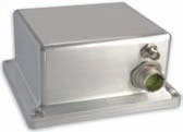
NovAtel Inc. has recently launched SPAN-CPT™, a powerful GPS/ INS receiver. It has fiber optic gyro and MEMS accelerometer inertial components from KVH Industries in one compact unit. Comprised entirely of commercial components, it has no special export restrictions, minimizing the operational complexities for customers whose products cross international boundaries. Mr. Jason Hamilton, product manager for SPAN group talks more about the receiver. |
|
|
What is so unique about SPAN -CPT receivers
SPAN-CPT brings together NovAtel’s high-accuracy, dual frequency GPS technology with high-performance Fiber Optic Gyro IMU to create a combined GPS/INS product. Unlike some products that have the GPS and INS as separate hardware components, SPAN-CPT has the GPS and IMU combined into a single, compact enclosure. The product will have the tightly-coupled GPS/INS integration already familiar to users of our SPAN technology which gives customers an optimal combination of GPS and IMU data. SPAN allows for faster satellite reacquisition during difficult GPS tracking scenarios and excellent absolute solution accuracy in challenging conditions. Solution data will be available at up to 100Hz. |
|
|
What kind of applications these receivers will be best used for?
The product will be usable for applications that require robust positioning in environments thatare traditionally difficult for GPS, like urban or forested locations; applications that require a full attitude output (roll, pitch, heading) and high output data rates. Applications for the product include manned or unmanned navigation, antenna pointing, mapping, aerial or ground survey and machine control. For applications where a local base station is not feasible, L-Band corrections using the Omnistar correction service is available. |
|
|
What is your collaboration with KVH Industries in developing these receivers?
NovAtel is providing the GPS side the product in the form of our OEMV receiver. KVH is providing the IMU for the system using their patented FOG IMU technology. The software in the system will leverage NovAtel’s tightly coupled SPAN GPS/INS integration.
The companies are both OEM-focused and have a strong track record in providing robust, high-quality products to their customer bases. Both parties are excited about the opportunities this new product provides for our customers. |
|
|
|
|
|
|
|


 (No Ratings Yet)


