| Positioning | |
Accuracy performance of hand-held GPS
|
||||||||||||||||||
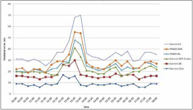
Satellite positioning is the term used to describe the determination of the absolute and relative coordinates of points on (or above) the Earth’s land or sea surface by processing measurements to, and/or form, artifi cial Earth Satellites. In this context, absolute coordinates refer to the position of a point in a specified coordinate system, whereas relative coordinates refer to the position of one point with respect to another (again in a specified coordinate system). Relative positions are generally more useful in surveying and can usually be more accurately determined. The fi rst applications of the technique were made in the early 1960s, but at that time the lengthy observing periods (weeks or months at a station) and rather low accuracy (standard errors of several meters) mean that it was only really useful for global geodesy. Important results were, however, obtained, especially in the connection of various national and continental terrestrial networks and in the determination of the overall position, scale and orientation of national coordinate systems. Nowadays, relative positions can, in certain favorable circumstances, be determined from satellite measurements with standard errors of a few millimeters within a few minutes. Clearly this makes satellite positioning a powerful tool for a wide variety of engineering applications. Moreover, satellite positioning has two very important advantages over its traditional terrestrial counterpart. Firstly, as in the case of inertial surveying, the derived positions are genuinely threedimensional. This is in direct contrast to traditional techniques where plan and height control have invariably been treated separately, both from a point of view of station siting (plan control points are normally on hilltops whereas height control points are usually located along roads and railway lines) and from a point of view of measurement and computation. Secondly, and perhaps most importantly, the traditional requirements of intervisibility between survey stations are not relevant. All that is required is that the stations should have a line of sight (in the appropriate part of the electromagnetic spectrum) to the satellite(s) being observed. These two advantages mean that all-purpose control points can usually be placed directly where they are needed, and are the essential reasons for the revolutionary effect that satellite positioning is having on many branches of surveying. GPS measurementThe satellite based positioning had been performed with TRANSIT system before the GPS was developed. This earlier system had two major shortcomings: the large time gaps in coverage and relativey low navigational accuracy. GPS was developed to replace the TRANSIT system in order to overcome these drawbacks (Hofmann-Wellenhof et al., 1992). Today, GPS provides continuous 24 hours a day and 365 days a year 3-dimentional positioning being it real-time or post-processing at any location all over the world. GPS is based on pseudorange measurement. Pseudorange is a distance between the satellite and the receiver. Any person anywhere on the earth could determine his own three-dimensional positioning expressed in ellipsoidal latitude, longitude and height (or cartesian coordinates). This procedure is accomplished by the simple resection process using the distance measured to satellites. The receiver clock is not synchronized with the satellite clock. This synchronization is the reason for the term pseudorange (Seeber, 1993). Hence, at least four satellites have to be observed at the same time to determine the three-dimensional position (Figure 1) The pseudorange is measured via code and/or carrier phase. Meter level accuracy can be performed by the code ranges whereas millimeter level accuracy by the carrier phases (Leick, 1995). Inherent GPS error sources are summarize in Table 1 (Holloway, 1997). Geodetic GPS receiversIn this respect, one notices that there is typically, much technical jargon. Esoteric phrases like double difference, carrier phase, pseudorange, cycleslip and integer ambiguity are part of the GPS user’s day-to-day vocabulary. There are different processing techniques which are also part of the GPS story. Terms like static, kinematic, pseudokinematic, semikinematic and fi ducial GPS can, at times, be confusing even to the most experienced GPS user. Inevitably, a large number of companies currently Table 1: Inherent GPS Error Sources and their Magnitudes Table (2): Some Main Characteristics of the Test Instruments Table (3): Results of the Test Fig 2: Accuracy Diagrams of Test manufacture GPS receivers. Some of these have been designed purely for the military user whilst others are for civilian use, some are just for navigating whilst others can be used for precise geodetic measurement. This paper is concerned with the first type. After the removal of selective availability by the U.S.A army in May 2000, the positional accuracy of these hand-held single-point navigatortype devices is improved from about ±1000m to perhaps better than ±20m. This happening also boosted the use of this type of receivers to an ever-expanding types of application from reconnaissance surveys through hydrography to the more challenging tasks of troops deployment. Aim of the testHand-held GPS receivers are now quite ubiquitous. They come from a number of manufacturers worldwide in a variety of designs, capabilities and potential applications. Their use has been widespread since the shutting off of selective availability (SA) by the U.S.A army in 2005. A quick glance at the Internet will show you a mind-boggling range of hand-held GPS receivers from vendors in Asia, Europe, Russia, U.S.A and Canada. A GPS user therefore will, understandably, wonder which GPS receiver will be commensurate with his kind of work. Receiver characteristics such as cost, user-friendliness, light weight, ease of use are important. However, level of positional accuracy achievable is the most important characteristic of any surveying system. This paper, therefore, reports the results of a modest experiment concerned assessing the accuracy of a selected number of hand-held navigator-type GPS receivers with different designs and capabilities, the aim being to give an insight into the expected accuracy ranges attainable in surveys carried out with such receivers and to explore possible application areas of such accuracy ranges. It is to be made clear from the outset, however, that it is not the intention of the present author to rate any of these instruments. Rather, the aim is not test their individual positional abilities in a limited and |
||||||||||||||||||
|
||||||||||||||||||
|


 (1 votes, average: 1.00 out of 5)


The articles is not complete. :(
Leave your response!