NEWSBRIEFS – REMOTE SENSING
Apr 2009 | Comments Off on NEWSBRIEFS – REMOTE SENSING
|
|
|
|
|
|
| |
 |
|
|
GeoEye sign reseller contracts. Beijing Earth Observation reseller in China
GeoEye, Inc. has signed agreements with several international resellers to provide high-resolution, satellite imagery and value-added products from its new GeoEye-1 Earth-imaging satellite to customers in China, Middle East, Turkey and Russia. Beijing Earth Observation, China has signed a new agreement with GeoEye to receive data from the GeoEye-1. www.geoeye.com
|
|
|
LPS supports Acropolis Laser- Scanning project
ERDAS has reported use of LPS software to create 3D models of the Acropolis in Greece. LPS is an integrated suite of photogrammetry software tools for generating terrain models, producing orthophotos, and extracting 3D features. www.erdas.com
|
|
|
|
RazakSAT to be launched on April 21
The images from RazakSAT, Malaysia’s first home-grown remote sensing satellite can be purchased from the Malaysian Remote Sensing Agency from middle of this year. RazakSAT will be launched from Kwajalein Island in the Republic of Marshall Islands, on April 21. www.remotesensing.gov.my
|
|
|
India’s own Google Earth causes security worries
India is launching its own version of Google Earth called Bhuvan for urban planning, officials said, amid worries that it could be misused after the Mumbai attacks probe showed militants had studied Google images of targets. It is a web-based service developed by India’s National Remote Sensing Centre (NRSC). It will help viewers gauge the soil type and ground water potential across the mainland with high resolution images and data from satellites. “We are working with the government for a 2.5 metre (7 feet) resolution,” NRSC director V. Jayaraman. But there are security concerns that Bhuvan could be misused because usage would be free. “Giving satellite images to everyone will obviously have some kind of a security impact,” said Ajai Sahni of New Delhi’s Institute for Conflict Management. Security analyst Uday Bhaskar said there needs to be a global consensus on availability of such technology. http://in.reuters.com
|
|
|
India to launch Israel-backed Radar Imaging Satellite
India has acquired a radar imaging satellite (RISAT) built with inputs from Israel that will be launched early next month, the officials said. RISAT has an all-weather viewing capability. Press Trust of India
|
|
|
Satellite Imagery over fire affected areas in Victoria, Australia
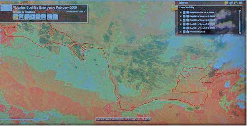 A screen shot of the fire damage from AAMHatch’s RapidEye Web Browser. In this colour infrared image, the red areas show healthy vegetation and the black areas show the fire damage. A screen shot of the fire damage from AAMHatch’s RapidEye Web Browser. In this colour infrared image, the red areas show healthy vegetation and the black areas show the fire damage.
|
|
|
|


 (No Ratings Yet)


