|
|
|
|
| |
 |
|
|
Leica TPS1200+ Total Station
Leica Geosystems introduces TPS1200+, its most competitive total station ever. It provides the market’s most accurate reflectorless EDM with the smallest laser dot and measures distances over 1000 meters. It has also launched Leica GNSS Spider V3.0, which provides the full range of GNSS Network RTK services including GPS & GLONASS.
|
|
|
New Eclipse™ Dual-Frequency GPS Receiver
Hemisphere GPS has announced Eclipse dual-frequency GPS receiver technology. It incorporates techniques for reducing code measurement noise and mitigating multipath signals, with centimeter-level accuracy. It allows OEM customers to integrate into a wide variety of precise applications including navigation and GPS machine control. micro.newswire.ca/release.cgi
|
|
|
|
Altus, Veripos pick Septentrio AsteRx2 Receivers
Septentrio shall deliver its dual-frequency GPS/GLONASS OEM receiver module AsteRx2 as a core component of Altus Positioning Systems’ new survey product, APS-3. It is a fully integrated, compact, lightweight and high-precision GNSS survey receiver. www.septentrio.com
|
|
|
GE introduces fleet management technologies
GE Equipment Services introduced VeriWise™ RAIL and VeriWise™ INTERMODAL, remote asset management solutions that provide customers with on-demand visibility into the status of their fleet and the cargo it carries. www.genewscenter.com
|
|
|
Navteq launches Arabic PDA
Navteq has launched its first Arabic-language PDA and mapping software. It has developed the Gulf Way PDA in conjunction with partner Maction Mobile Technologies. The Gulf Way features full English and Arabic-language functionality and GCC mapping software. www.arabianbusiness.com
|
|
|
TomTom reveals GO 920 T
TomTom reveals GO 920 T. It comes preinstalled with complete maps of Europe and USA & Canada on the 4 GB of internal memory. It includes the new Enhanced Positioning Technology and an RDS-TMC Traffic Receiver to receive up-to-date traffic information. www.tomtom.com
|
|
|
Infotech gets Survey of India contract
Infotech Enterprise Ltd (IEL) has bagged a contract from Survey of India for mapping the cities of Ahmedabad and Chennai.
IEL will be employing softcopy photogrammetry technology to extract features in 3-D image. The project will be completed in four months. http://economictimes.indiatimes.com
|
|
|
Trimble GNSS receiver module
Trimble has introduced the Trimble BD960, RTK compact GNSS card for high-precision guidance and control applications. The receiver is designed to allow OEMs and system integrators to easily add centimeter-level positioning to specialized or custom hardware solutions. www.trimble.com.
|
|
|
Optech upgrades ALTM-NAV
Optech announced a major upgrade to ALTM-NAV integrated mission planning, navigation, and operations software through the incorporation of underlying digital elevation models (DEM). Users will be able to plan airborne missions more effectively and efficiently using ancillary DEM information from a variety of sources. www.optech.ca
|
|
|
NGA awards Intermap additional USD 1.3 million contract
National Geospatial-Intelligence Agency (NGA) has awarded Intermap Federal Services Inc. subsidiary a USD 1.3 million contract to provide imagery and elevation data from Intermap’s comprehensive NEXTMap USA geospatial dataset. The licensed data includes the gulf coast areas of Alabama, Arkansas, Florida, Louisiana, and Mississippi. www.intermap.com
|
|
|
Magellan® MobileMapper® CX GIS Data Collector
Magellan, has introduced the MobileMapper CX, a handheld sub-meter real-time GPS receiver for GIS users that comes with application software, a phone-like keypad and outstanding communications. The software has key GIS data logging capabilities include GIS feature libraries for logging feature descriptions; support for logging point, line and area features; an offset function for logging hard to reach features; and more.
|
|
|
Pitney Bowes creates single software Business Unit
Pitney Bowes Inc. announced that it’s Pitney Bowes Group 1 Software and Pitney Bowes MapInfo business units, acquired separately, will combine into a single software company called Pitney Bowes Software. The move is effective immediately. Mike Hickey, currently president of Pitney Bowes MapInfo, will become president of the combined entity Pitney Bowes Software. http://news.pb.com
|
|
|
BarZ and u-blox introduce multimedia GPS tour guide
BarZ Adventures, has announced their cooperation in bringing GPS-based tour guides to a number of U.S. National Parks and Zoos. It introduced the GPS and Zoo Ranger, a handheld device which delivers multimedia content based on the user’s current location. It uses u-blox’ SuperSense® Indoor GPS technology.
|
|
|
DVP-GS version 6.4 release
Groupe ALTA has released Version 6.4 of its professional photogrammetry software DVP-GS. Key features in this update include enhanced Vector editing tools like: Move multiple vertices (including shared vertices between 2 or more elements) and element smoothing and better management of vector reference files. www.groupealta.com |
|
|
Spirent® announces enhanced global support for satellite test products
Spirent announced improvements to customer support capabilities across the world. In Asia, Spirent has added dedicated support facility for its GNSS test systems, in Beijing, P. R. China enhancing Spirent’s existing support offices in USA and Europe. The new support facility provides technical support for customers across Asia as well as a local calibration and repair services. A dedicated suite of test equipment has been commissioned in Fort Worth, Texas similar to the Verification Office facilities recently announced by Spirent for in the UK.
|
|
|
NovAtel Inc. Launches OEMV(TM) Product Line Enhancements
NovAtel Inc. recently launched the latest enhancements to its OEMV product line, including Version 3.210 firmware release and the new SMART-V1G enclosure. The latest firmware features many performance enhancements, including the addition of GLONASS measurement and position capability into NovAtel’s single frequency AdVance(TM) Real Time Kinematic (RTK) product models.
|
|
|
Rockwell Collins unveils GPS receiver for the commercial market
Rockwell Collins has introduced the Polaris family of Standard Positioning Service (SPS) GPS receivers. It offers the same functionality featured in its popular Defense Advanced GPS Receiver (DAGR) and Miniature Precision Lightweight GPS Receiver Engine (MPE), but without the Selective Availability Anti-Spoofing Module (SAASM). www.rockwellcollins.com
|
|
|
Applanix unveils new GNSS software
Applanix has introduced new version of GNSS-Aided Inertial post-processing software for airborne mapping and surveying applications–the POSPac™ Air 5.0 software. It includes module for using GNSS network corrections to increase accuracy.
|
|
|
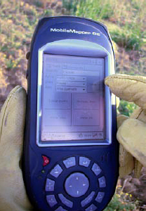
MobileMapper CE Makes Dangerous Work Safer
Wildfires have become a serious problem in Extremadura, a 41,600 sq km area in Spain. Wildfire fighters are equipped with the MobileMapper CEs to pinpoint their location and view topographic maps and aerial photos that display detailed information about their surroundings, including the location of nearby roads, where they lead, contour changes, locations of water points and the amount of water available in each.
|
|


 (No Ratings Yet)


