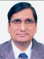
| His Coordinates | |
“Our focus will be on meeting user needs”
says Mr. Swarna Subba Rao, Surveyor General of India about the upcoming agenda for Survey of India. |
|
As the Surveyor General of India what are your immediate priorities for Survey of India?
Survey of India is India’s National Survey and Mapping Organisation and is the oldest scientific department of the country. In the years since its establishment in 1767 it has developed a rich tradition and legacy of mapping. It is also a very large organisation which has not only grown but also evolved over the years.
But the entire dynamics of the geospatial industry has changed in the last few years due to the rapid developments in technology and the changing user needs. For Survey of India to be in tune with this changing scenario there is a need to restructure the organisation.
We have some of the most qualified and dedicated professionals with us, but we need to re-orient the people, infuse the latest IT and re-design some of the technical aspects towards meeting the evolving needs of the users.
What do you think Survey of India needs to do to meet the varied requirements of the growing number of spatial data users in the country?
First of all we need to understand the changing requirements of the various users. Today the customers look for softcopy data in formats which are compatible for their specific needs. In many instances the data has to be GIS ready.
Survey of India is known for its quality products, but earlier all our products were used to be in hard copy format. Then we started providing data in softcopy format. Now we need to focus on providing data to users in the formats required by them and user friendly.
Besides the routine maps like the toposheets, we would try to meet all the geospatial data needs of the users; be it from the government, academia or private in a timely and efficient manner.
Mapping and technology are inseparable today. How do you see this relationship developing in Survey of India?
I would like to see Survey of India adopt IT in it’s core activities. Information Technology is a very important aspect for us as an organisation. For an effective administration as well as to meet the current geospatial data requirements we must make ourselves IT competent.
Where does Survey of India stand as a ‘brand’ today?
With its long history and legacy, Survey of India is already a well established brand in the geospatial domain. However, there is a definite need to revive this brand and re-establish our identity as a leading geospatial data provider.
Public-Private-Partnership (PPP) as a model of operation has got a fillip in India in the recent past. Do you think Survey of India can also capitalize on this concept?
The total geospatial needs of the country cannot be met by Survey of India alone. We will need to go into partnership, but will have to work out the modalities as per the rules and regulations of the government.
We would definitely like to explore avenues where we can work together with the industry to enhance the geospatial data availability for the users. We may also need to outsource some work depending on the evolving needs.
What is role of Survey of India in programs such as the National Land Resource Management Programme (NLRMP) and National Urban Information System (NUIS)?
We are very much part of these programs. Survey of India is actively involved in both the NLRMP and NUIS.In case of the NLRMP, The Indian Institute of Surveying and Mapping (IISM) has been imparting training to State revenue and land records department officials to meet their needs for modern technology in computerization of land records. For NUIS we will be completing the mapping in the next few months.
Do you think maps and the survey profession get adequate attention in the education system in India?
There is a lack of awareness about maps and their importance in general. I think the educational institutions can play a crucial role in creating an interest in and awareness about maps among the students.
When the interest and awareness increases there will automatically be more interest in map making and surveying.
There is also a definite need for capacity building at the higher levels. I would like to add that the IISM is playing and important role towards this capacity building and has a tie up with Jawaharlal Nehru Technological University (JNTU), Hyderabad for certain courses.
Survey of India and National Spatial Data Infrastructure (NSDI) – please comment.
NSDI is a great initiative to meet the spatial data requirements of the various users in the country. Considerable progress has been made by NSDI in the last decade. But what NSDI is trying to achieve takes time and the challenge is to engage more and more organisations in the process. Survey of India has supported and will continue to support the NSDI initiative. There is synergy in the goals of both Survey of India and NSDI – to make geospatial data available to users. We look forward to working with the various NSDI partners in taking NSDI towards its goal.
Where do you see Survey of India in 2015?
Here I would like to re-emphasise the vision of Survey of India today, which is to ‘take a leadership role in providing user focused, cost effective, reliable and quality geospatial data, information and intelligence for meeting the needs of national security, sustainable national development, and new information markets.’ I hope that in the next five years this vision and chosen mandate of Survey of India will be visible in letter and spirit.


 (No Ratings Yet)


Leave your response!