| Surveying | |
What does our world really look like?
|
||||
Usually, us human beings tend to cumulate in urban centres, and if we go places, then to those which we consider as worthwhile a visit, such as the Tower of Pisa or Old Faithful Geyser in Yellowstone National Park. Due to our unbalanced focus on certain areas, we have a distorted image of our world – much more jam-packed of houses, roads and people than it actually is.
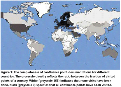
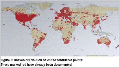
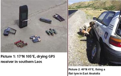
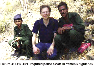
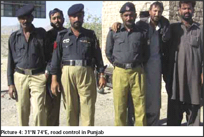
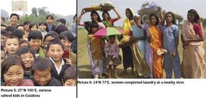
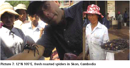
An approach to sample the worldIf we want to have an unbiased view of our earth surface, we need to sample it that independently of any existing human infrastructure, topography and accessibility. One clever idea that realizes true independency is simply to identify an evenly distributed set of sample points by coordinates. A straightforward approach is to sample all the exact spots where an integer degree of latitude and an integer degree of longitude meet, such as 20°00’00”N 106°00’00”E. Those 64,442 points are referred here as confl uence points. Using the WGS84 datum the locations of those points are exactly defi ned. If we only knew what these sites – at least those 21,541 being on land – look like, the title question could be answered. Considering that pure satellite pictures do not give the true impression of the spot compared to the scene when actually standing on it, taking pictures of all confl uences means to go to the confl uence points. This is quite an effort, since they form a grid with a cell size of roughly 100 km. by 100 km The Confluence projectFortunately, for the past decade an attempt is being made by volunteers all over the world to visit the confluence points and document the scenery with pictures and narratives. All reports of visits are submitted to the website www.confl uence.org where they are published. Now, exactly 10 years into the project with several thousand people actively participating, one might guess that all points must have been visited. De facto, only 26.9% of the project goal is fulfilled at the time of writing. Why is the progress so slow? The answer can be found when recalling that these points ignore our built infrastructure: they let ‘confluence hunters’ drive into deserts, wade through swamps, argue with land owners and run for miles after their vehicle has got stuck in the sand, thereby always counting down numbers at the displays of their GPS receivers. The time to reach confl uence points ranges from 10 visits in 1 day (as I managed to do in Germany, a country with dense infrastructure) up to 1 visit in 10 days for reaching the world’s highest confl uence at 5835m in Xizang (Tibet). The disparity of infrastructure, population density, and awareness of the project hampers the fulfilment of the project goal. Currently, there is a huge gap in completeness of the project between different regions in the world. Figure 1 shows the current achievement in all countries. On the top of the list of best documented countries is Luxembourg with its only confluence point (50°N 6°E) being visited 13 times. Even in a larger country such as Germany, its 48 confluence points have been documented more than 5 times on average. On the other end, in areas where the people’s basic needs such as water, food and health are far from being satisfied, the search for confl uence points is not ranked high on the to-do-lists. The Democratic Republic of Congo (Zaire) is leading the list of incompleteness: not a single of the 189 confluence points in Congo has been visited nor even attempted. Clearly, most of the Congolese are not aware of the project and not equipped with the required instruments to survey their nearby confluence points. On the top of everything the access to the sample points is challenged by tropical rain forests and intestine wars. The density of visited confl uences for a country however is hardly correlated to the population density (correlation coeffi cient +0.15), but clearly correlated in the GDP (correlation +0.6) and the number of internet users per 1000 inhabitants (correlation +0.6). Figure 2 shows the locations of visited confluence points – within large countries like China or Russia the density of visits varies significantly. Russia’s easy accessible areas in the west and along the industrial belt are almost completed while the most of Siberia which is mostly covered by swamps, uninhabited taiga and tundra is still untouched by confluence hunters. Challenges in finding confluencesNavigating to confluences can be challenging – physically where a coarse road network demands long hikes or climbs, such as the Tibetan confl uence 30°N 90°E where the visitors suffered a physical toll (one of them was rushed to the hospital after the trip) because the confluence hunt involved a 6-day, 75 km pack-horse trip at altitudes continuously above 5000 m without any villages or human infrastructure. Sometimes negotiation skills are required when points are located in restricted areas, such as the last remaining virgin confl uence on the contiguous USA (37°N 116°W) that resisted all attempts for visits due to its location in the Nevada nuclear test site, which is very restricted U.S. government property. However, nothing is impossible if there is a strong will – so finally this last land confluence was documented. I can clearly say that the challenge of finding confluences can be fascinating – if not addictive. From a rational point of view, “confluencing” seems to be pointless, if not foolish. Why should one shoulder so much effort just to get to a pointless place on earth? Well, there are several reasons: • Often takes you to places that never sees tourists and has untouched wildlife. If the area is populated then friendly people are happy to see you coming because they rarely have visitors. • Provides a challenge in everyday life. Nowadays, modern societies satisfy most needs causing a desire for further goals. Purposelessness is driven away by the collective aim of the project. • Provides training skills in orientation, navigation, negotiation, climbing, hiking, problem solving, timing, improvising, organising, geography, transportation and many more. • Discover the fascinating and intriguing sides of ordinary places not on the “must see” agenda of most travellers and discover the fascinating and intriguing sides of those places which are supposedly uninteresting. • Last, but not least, participate in the Degree Confluence Project. There are few projects where volunteers from all over the world are unified by a common goal. After having personally visited 82 confluences in 24 countries I can clearly say that despite the fact that places are very different, each confl uence visit involves the following steps: The planning phaseIt is essential to look at the available time budget and estimate how long the whole trip from the highway, country road, track, footpath, crosscountry to the point and back will take. Unsuccessful visits are almost always due to the fact that the real trip turns out to last much longer as estimated. Therefore it is useful not to face tight deadlines such as darkness, bus schedules or promises to spouses. A good rule of thumb is to estimate your time on getting there, and then double it. If you finish early, congratulate yourself. The journeyProblems will always occur despite thorough planning. Facing and solving problems should be taken as part of the play. When I tried to get to a remote confluence in Laos’ jungle at a rainy day and almost reached the confluence, the GPS receiver quit working. After I had dried the instrument in the sun for two days (picture #1) I started again and made it a successful visit. I had a flat tyre in Turkey (picture #2), my car got stuck a remote part of Iran’s desert, and issues with the police had to be solved in Yemen (picture #3) and Pakistan (picture #4). Taking a local guide, being patient with locals and communication with people who know the area are key to success. We shouldn’t forget that some places we consider disagreeable are other people’s homes. Standing at the confluenceIt is the highlight of any confluence trip, but usually time constraints, weather conditions, animals, or worried landowners keep the visits short. The visit can be intense if the point is near a school in remote China (#picture 5), a river in India (#picture 6) or a Cambodian town where spiders are delicacy (#picture 7). Reporting the confluenceSubmitting a report and pictures to the website can be quite some effort, but is usually rewarded by feedback from the confl uence community. |
||||
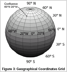
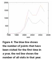
Equidistribution on the sphereOnly when all degree confluences have been visited will a thorough view of our planet’s surface be possible. One might argue now that all meridians meet at the poles and that pole areas have a higher density of latitudelongitude intersections than the tropical regions. This is du tothe defi nition of geographical coordinates, which are referenced on the WGS84 datum and its underlying Geodetic Reference System 1980 (GRS80) ellipsoid, see Figure 3. As a consequence the distance between degrees of longitude varies considerably between 111.32 km at the equator to 1.95 km at the 89° latitude circle. The distances of latitude circles however do not vary significantly (between 110.57 km at the equator to 111.69 km between 89° latitude to the poles). Whatever coordinate system is used, it is not possible to equally distribute points on the sphere except in a few special cases called the platonic solids like the Tetrahedron or Dodecahedron. More details see Womersley (2005). For the confluence project this problem is solved by excluding some points near the poles and calling them “secondary” while all others are considered as “primary”. Further details can be found on the website of confl ence.org. The futureWill the project ever be completed? Considering it took 10 years to visit 25% of the points, a linear prediction would give a positive answer, but would also suggest a completion in the year 2036, which means another 30 years of hunting unvisited points. Well, some variables make this calculation unreliable. The last remaining unvisited point might be hard to conquer (e.g. imagine trying to visit a confl uence in a military compound in North Korea) or just unattractive to visit (as most of Antarctica seems to be with currently only 5 out of 1718 primary points visited). On the other hand, the project has gained publicity and attracted a rising number of active members. If the whole world population would participate, I guess that all points can be reached within in a couple of days. A realistic forecast can be made by looking at the past. Figure 4 shows how the project developed over the last 10 years. While the number of total visits is still increasing, there is a downward tendency for the number of first visits of confluence points over the last five years. If the downswing continues, a completion in 30 years is doubtful. Here is my idea how one can break all records and visit 360 new confuences in one day (350 of them being secondary): circle the South Pole at the 89° latitude circle on a snowmobile. If you take the required pictures of the confluences (being 1.95 km apart) on-the-fly, the 700km journey can be done on an average speed of 30km per hour. But I guess that realisation face a lot of logistical challenges and also involve some costs. In conclusion I can say that it is currently an open question whether the project goal will be met one day or not. May this article contribute to the awareness of confluences and help to answer this open question someday with: “project completed!”. Womersley, R (2005), Distributing points on the sphere Homepage Articles School of Mathematics, UNSW, http://www.maths.unsw.edu. au/school/articles/me100.html |
|||||||||||||||
|
|||||||||||||||
|
Pages: 1 2



 (No Ratings Yet)


