Navigation


Trends in GNSS/INS integrated navigation technology

Mar 2007 | Comments Off on Trends in GNSS/INS integrated navigation technology

 
GNSS/INS integrated systems will benefit from deep integration architecture and AI technology
   

Global Navigation Satellite System (GNSS) consists of GPS, GLONASS and Galileo which is still under construction by the European Union. GPS is the most widespread GNSS in the world and applies successfully in so many fields such as positioning, navigation, geodesy, mapping, timing and so on. However, GLONASS has not done its work well for about ten years because of lack of funds. In summer of 2006, Russia’s GLONASS program continued its comeback and will have a full 24-satellite constellation by the end of 2009. Notably, China has a regional RDSS system using three geostationary satellites since 2000.

INS is a self-contained positioning and attitude device. In other words, it meets the all-environment requirement. The primary advantage of using INS is that velocity and position of the vehicle can be provided with abundant dynamic information and excellent short term performance. The main shortcoming is that the INS accuracy degrades greatly over time.

There is a strong possibility that a GNSS/INS integrated navigation system has superior performance in comparison with either a standalone GNSS or INS because of their complementary operational characteristics. Since 1980s, researchers have begun to investigate GPS/INS integrated navigation technology and the experimental results showed that GPS/INS integrated systems can efficiently improve the navigation performance. With the development and application of low-cost inertial measurement unit (IMU) and GNSS receiver, GNSS/ INS technology has become one of the most popular methods of navigation for users worldwide.

On the one hand, the low-cost IMU, especially MEMS IMU, means low accuracy and low performance. It is hard to be directly usable as sole navigation systems because of their large random errors. On the other hand, navigation accuracy and integrity of GNSS will be degraded in the presence of radio frequency interference, hostile jamming and high dynamical situations in the so-called navigation war which was brought forward formally by USA in 1997. Aiming at these problems, researchers have recently focused their attention on deep integration and intelligent integration. These two methods will improve the robustness and precision of the integrated system greatly. Accordingly, researchers attach more importance to these two methods which are regarded as the trends in GNSS/ INS integrated navigation technology.

Trend: Deeply integrated navigation

There are three generic functional architectures for GNSS/INS integration, that is, loosely, tightly and deeply (also named ultra-tightly) integrated mode. Traditionally, most GNSS/INS hybrid systems have been mechanized using loose integration or tight integration. Loosely integrated mode is the easiest and simplest approach because it is based on the independence of the GNSS and INS navigation functions. Although it provides some tolerance to failures of subsystem components, loosely integrated mode can not work when GNSS receiver doesn’t track and lock at least four satellites at the same time. Tightly integrated mode where a GNSS receiver is not regarded as a navigation subsystem but as a sensor that provides pseudorange (PR) and delta pseudo-range (DPR) was proposed to overcome the shortcomings of loose integration. This kind of mode benefits from GNSS measurement updates even if there are less than four satellites available for a complete GNSS navigation solution. It also reduces the complexity of the integrated filter due to lesser correlation of the integration variables (PR, DPR). However, tight integration is difficult to meet the demands of anti-jamming and high dynamical situations.

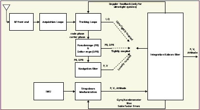
Designers have conceived of the deeply integrated mode which has higher performance than loosely integrated and tightly integrated mode. Figure 1[1] shows GNSS/INS architectures: loosely integrated mode, tightly integrated mode and deeply integrated mode. For deeply integrated mode, the GNSS measurements I (inphase) and Q (quadrature) from the GNSS correlator are integrated with the INS measurements. As shown in figure 1, one of the key techniques in the deep integration is the integration of INS derived Doppler feedback to the carrier tracking loops.

The deeply integrated mode provides the following manifold advantages:

1. Jamming to signal (j/ s) ratio improvement Outputs of the deeply integrated filter are fed back into the tracking loops and used to control the code and carrier replica signals for each satellite channel[2]. A closed-loop comes into being and remains in lock even at low input signal-to-noise ratios
img192
Fig.1 GNSS/INS architectures: loosely, tightly and deeply integrated mode when aided by MEMS IMU.

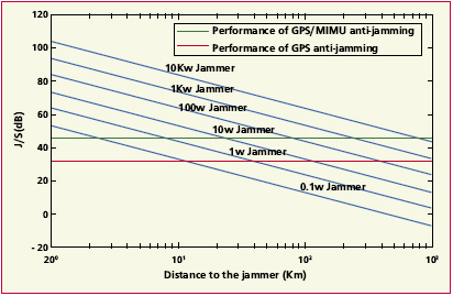
In principle, the antijam of GPS receiver is about 32dB[3]. As shown in Figure 2, GPS receiver can’t trace the signal well when there is a 0.1W jammer only 10km far away. Antijam improvements in deeply integrated mode relative to non-inertial-aided loop are 11dB. That was evaluated over a realistic precision guided munition (PGM) scenario in the presence of broadband jamming [2].
2. Improving system accuracy Firstly, the accuracy of the raw GNSS measurements is increased due to lower tracking loop bandwidths aided by inertial data in deeply integrated mode. Secondly, errors of INS, mainly gyros/ accelerometers bias and scale factor errors, is calibrated periodically by integrated filter outputs. Thirdly, the integrated filter (usually kalman filter) is an optimal fusion including GNSS signal tracking loops and correlators which are contained in loosely and tightly integrated mode.
3. High dynamic performance Inertial data provide the dynamic reference trajectory for the GNSS signal integration inside the receiver’s correlators, which results in ‘dynamic-free'[4] GPS signals that are sent to the tracking loops facilitating a significant reduction in the carrier tracking loop bandwidth, hence providing accurate carrier and code phase measurements.

The standalone GPS receiver uses a 2nd order carrier-tracking loop with a loop bandwidth of about 12 to 18Hz. However, deeply integrated system also adopting a 2nd order carrier-tracking loop the bandwidth can be reduced to 3Hz. That means that deep integration can work well in high dynamic environment.

Good technology can lead to perfect productions. Hereby, a guidance, navigation and control flight management unit which was housed in a small, light weight, low power package based on deep integration and MEMS IMU was tested successfully for the challenging requirements of modern tactical applications[5, 6].

Trend: Intelligent integrated navigation

The kalman filter is the most popular estimation tool for GNSS/INS integration because it is optimal in theory. However, in fact, real system can’t satisfy all requirements of KF, such as supposed Gauss white noise, ideal dynamics model, and none error linearization. Furthermore, the more widely low cost IMU is adopted, the more obvious the limitations of KF become.
Nevertheless, Artificial Intelligence (AI) is a powerful tool for solving nonlinear problems that involve mapping input data to output data without any prior knowledge about the mathematical process involved. All kinds of conceptual intelligent navigator combining AI techniques were put forward to overcome the demerits of KF and improve the accuracy and reliability of the integrated systems.

 
–~~~~~~~~~~~~–

In recent years, there have been some successful AI methods applied to GNSS/INS integration. Two artificial neural networks (ANN)- based INS/DGPS integration schemes for vehicular navigation were developed with a conjugate gradientbased training algorithm[7]. A new method is presented to improve the MEMS IMU/GPS performance using fuzzy modeling[8]. The GNSS/INS integration architecture using ANN which has the ability to mimic a human navigator, is capable of providing real time prediction and improve the performance during GNSS outages[9]. An Adaptive-Neuro-Fuzzy-inferencesystem (ANFIS)-KF model is used to correct the estimated KF outputs, which adopts Fuzzy-OLS algorithm for online ANFIS adaptive learning and impairs the influence of MEMSIMU thermal variation by ANFIS[10]. Three AI-based methods, that is, a fuzzy logic rule-based system, a fuzzy expert vehicle dynamics identification system and a neural networks-based compass calibration algorithm, have been developed for GPS/MEMS INS integrated system[11].

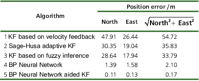
We consider a case study that illustrates performance benefits of RDSS/INS integration[12]. In the case, the horizontal accuracy of RDSS positioning is 100 m and the minimum interval of positioning is 1.5 s because of active positioning mode. A tactical-grade IMU is used. Table 1 shows comparison of positioning error using five algorithms with same experimental data. BPNN aided KF

img211

Fig.2 Performance of GPS/MIMU antijamming vs. GPS anti-jamming

has a best position accuracy. BPNN algorithm is also quite good. KF based on fuzzy inference is a little better than Sage-Husa adaptive KF. This indicates that algorithms with AI techniques improve positioning accuracy.

Conclusion

It can be seen from the above analyses that GNSS/INS integrated systems will benefit from deep integration architecture and AI technology. Some instructive researches have been set up recently, but it is just a beginning. Overall, we believe that the trends of deep integration and intelligent integration would be referred clearly as one of the most important directions during the wide applications of the integrated systems.

As fabrication techniques of MEMS sensors develop increasingly, some manufacturers foresee that the gyro bias error of a 2 in3-sized MEMSbased IMU will be achieved to 0.010/h by 2010[13]. In addition, the low cost, lightweight, and high G of MEMS sensors are the driving factors in more and more applications. Integration involving deep integrated mode and AI techniques should be made more feasible and attractive. Based on this, a low-cost attitude determination GNSS/ MEMS INS integrated navigation system is likely to be designed.

References

R. BABU and J. WANG, “Improving the quality of IMUderived Doppler estimates for ultra-tight GPS/INS integration,” in GNSS2004, Rotterdam, The
Table 1 Comparison of positioning error in RDSS/INS integrated navigation system
img222


Netherlands, 2004, pp. 144-151.

2] E. J. Ohlmeyer, “Analysis of an Ultra-Tightly Coupled GPS/ INS System in Jamming,” in 2006 IEEE/ION, Position, Location, And Navigation Symposium, 2006, pp. 44-53.

3] S. Gunawardena, A. Soloviev, and F. v. Graas, “Real Time Implementation of Deeply Integrated Software GPS Receiver and Low Cost IMU for Processing Low-CNR GPS Signals,” in ION 60th Annual Meeting, Davton,OH, 2004, pp. 108-114.

4] R. BABU, “Mitigating the correlations in INS-aided GPS tracking loop measurements: A Kalman filter based approach,” in 17th Int. Tech. Meeting of the Satellite Division of the U.S. Institute of Navigation, Long Beach, California, 2004, pp. 1566-1574.

5] T. M. Buck, J. Wilmot, and M. J. Cook, “A High G, MEMS Based, Deeply Integrated, INS/GPS, Guidance, Navigation and Control Flight Management Unit,” in Position, Location, And Navigation Symposium, 2006 IEEE/ION, 2006.

6] J.Beser, S.Alexander, R.Crane, S.Rounds, J.Wyman, and B.Baeder, “A Low-Cost Guidance/Navigation Unit Integrating a SAASMBased GPS and MEMS IMU in a Deeply Coupled Mechanization,” in ION GPS Portland, 2002.

7] N. El-Sheimy, K.-W. Chiang, and A. Noureldin, “The Utilization of Artificial Neural Networks for Multisensor System Integration in Navigation and Positioning Instruments,” IEEE TRANSACTIONS ON INSTRUMENTATION AND MEASUREMENT, vol. 55, pp. 1606-1615, OCTOBER 2006.

8] W. Abdel- Hamid, T. Abdelazim, N. El-Sheimy, and G. Lachapelle, “Improvement of MEMS-IMU GPS performance using fuzzy modeling,” GPS Solution, vol. 10, pp. 1-11, 2006.

9] K.-W. Chiang, “INS/GPS Integration Using Neural Networks for Land Vehicular Navigation Applications,” in Department of Geomatics Engineering. vol. Doctor Calgary: University of Calgary, 2004.

10] W. Abdel-Hamid, “Accuracy Enhancement of Integrated MEMSIMU/ GPS Systems for Land Vehicular Navigation Applications,” in Department of Geomatics Engineering. vol. Doctor Calgary: University of Calgary, 2005.

11] J.-H. Wang, “Intelligent MEMS INS/GPS Integration For Land Vehicle Navigation,” in Department of Geomatics Engineering. vol. Doctor Calgary: University of Calgary, 2006.

12] H. Xiaofeng, W. Wenqi, T. Yonggang, and H. Xiao-ping, “Intelligent RDSS/INS Integrated Algorithms for Land Vehicle Navigation,” in Symposium Gyro Technology 2006, Stuttgart, Germany, 2006.

13] S. GT, “INS/GPS technology trends,” in NATO research and technology organization lecture series232 advances in navigation sensors and integration technology London, 2003


HE Xiaofeng

Doctoral candidate , Lab of Inertial Technology, College of
Mechatronics Engineering and Automation, National Univ.
of Defense Technology, Changsha, PR.China
hexf_lit@126.com
   

HU Xiaoping Professor

College of Mechatronics Engineering and Automation,
National Univ. of Defense Technology, Changsha, PR.China
   

WU Meiping

Associate Professor National University of Defense
Technology Changsha, PR.China


My coordinates
EDITORIAL
 
His Coordinates
Steve Berglund
 
News
INDUSTRYLBS | GPSGIS  | GALILEO UPDATE
 
Mark your calendar
May 09 TO DECEMBER 2009

«Previous 1 2View All| Next»

Pages: 1 2

1 Star2 Stars3 Stars4 Stars5 Stars (No Ratings Yet)
Loading...