| Navigation | |
The conceptual intelligent navigator
|
||||
|
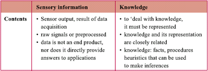
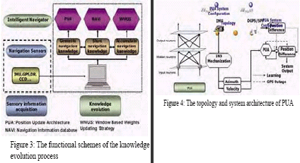
The goal of developing any intelligent machine is to mimic human behaviors and achieve certain goals that can not be fulfi lled by adopting conventional methods [Cawsey, 1998]. According to Honavar and Uhr [1994], the intelligence can be defi ned as the ability to learn, understand and adapt. The human brain has the ability to learn adaptively in response to knowledge, experience and environments by a network of interconnected adaptive information processing elements that transform inputs to desired outputs [Principe et al, 2000]. In other words, the intelligence fi rst requires the ability to transform the acquired sensory information or raw data to certain form of useful information which can be regarded as knowledge. In addition, it demands a continuous learning process to guarantee the accumulation of acquired knowledge. Thus, the conceptual intelligent navigator is expected to have the ability to learn and adapt. Learning is defi ned as a process of acquiring and memorizing new information, knowledge and experience [Cawsey, 1998]. The adaptation can be regarded as the ability of the information processing elements to change in a systematic manner and alter the nonlinear transformation between inputs and outputs. In other words, learning and adaptation are interpreted as the mechanization of knowledge evolution process. Therefore, the intelligence of human is derived and accumulated through continuous sensory data acquisition and knowledge evolution. Table 2 illustrates the comparison between sensory information and knowledge. In addition, Figure (2) depicts the process of adopting acquired sensory information to generate certain knowledge through human vision. Being inspired by Figure (2) and Table 2, thus, three functional schemes of the knowledge evolution process of the conceptual intelligent navigator that fulfi ll the requirements of selflearning or adaptive learning can be identifi ed, as shown in Figure (3). As indicated in the Figure (3), to acquire the navigation knowledge for further processing, Chiang [2004] proposed several ANNs based INS/GPS integration schemes that use Multi-layered for further processing, Chiang [2004] proposed several ANNs based INS/GPS integration schemes that use Multi-layered Feed-forward Neural Networks (MFNNs). The MFNNs trained by the backpropagation algorithm is the most well-known and most common used neural network today. The INS/GPS integration architecture implemented in this article isalledthe Position Update Architecture (PUA) which consists of a two layered feed-forward neural network. It integrates the data from INS and DGPS and mimics the dynamical model of the vehicle to generate navigation knowledge. Thus the latest acquired navigation knowledge can The topology of PUA is illustrated on the left side of Figure (4). The input neurons receive the velocity at current epoch (VINS(t)), azimuth at urrent The desired outputs (dNGPS(t), dGPSE(t)) are provided by GPS during ignal availability in either DGPS or SPP mode of operation. As long as the GPS signals are available for more than 4 satellites, the learning process continues to reduce the estimation error in order to obtain optimal values of the NN parameters. Thus, the navigation knowledge can be learnt, stored and accumulated during the availability of the GPS signal. On the other hand, during GPS signal outages, the latest acquired navigation knowledge can be retrieved from the “brain” of As indicated in Figure (3), the second step towards building the conceptual intelligent navigator is to store the learnt knowledge acquired in the previous section. As a result, a navigation information database (NAVi) that contains the acquired and learnt navigation knowledge can serve as the “brain” of the conceptual intelligent navigator, as shown in the Figure (5). |
||||
|
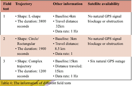
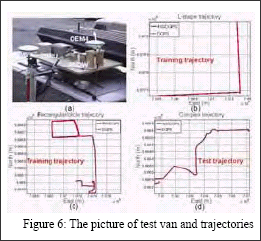
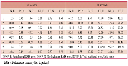
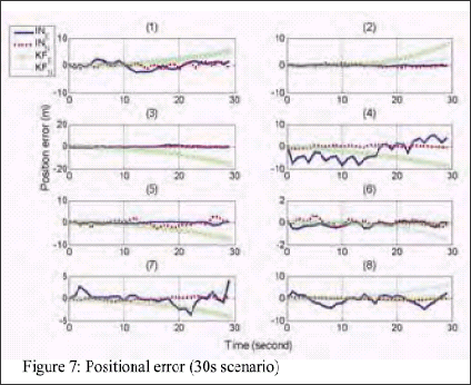
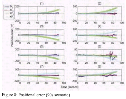
According to most of the NN related literatures, only the synaptic weights are interpreted as the learnt knowledge, however, Chiang [2004] suggested that the training samples that were applied during pervious learning processes should be stored and regarded as a part of the navigation knowledge to maintain the generalization capability of the proposed architecture after current or future learning process. As indicated in Figure (3), the synaptic weights are the core components of the navigation knowledge; the fi nal step towards building the conceptual intelligent navigator is to develop a strategy to accumulate the acquired navigation knowledge by updating the synaptic weights whenever the GPS signal is available. In the case of INS/GPS integration for navigation applications, it is required to track direction changes and mimic the motion dynamics utilizing the latest available INS and GPS data. In other words, the synaptic weights should be updated during the navigation process to adapt the network to the latest INS sensor errors and the latest dynamics condition whenever the GPS signal is available. To implement such criterion, Chiang et al., [2004] proposed a window based weights updating strategy to utilize the synaptic weights obtained during the conventional off-line training procedure (or probably from previous navigation missions) and stored in the NAVi. This criterion utilizes the latest available navigation information provided by the GPS signal window to adapt the stored synaptic weights so that they can be applied to mimic the latest motion dynamic and INS sensor error. Chiang et al., [2004] demonstrated the advantages of the proposed strategy in terms of the prediction accuracy during GPS signal blockages in real time mode. Since the ANNs training procedure takes time, updating the synaptic weights immediately at the latest available sample of a GPS signal before outage is diffi cult. However, the utilization of the proposed method can still provide reasonable prediction accuracy during GPS signal outages since it can utilize the latest acquired and learnt navigation knowledge to provide real time solutions. Therefore, the conceptual intelligent navigator has the ability to guarantee the knowledge evolution through the continuous learning process during the availability of GPS signal. Comparing to the traditional navigator that uses Kalman fi lter algorithm, the proposed conceptual intelligent navigator demands more storage space to accumulate navigation knowledge. However, as the accumulation of the navigation knowledge makes the conceptual intelligent navigator different from the traditional navigator, it is the price to pay [Chiang, 2004]. Results and discussionsTo evaluate the performance of the conceptual intelligent navigator, three fi eld tests were conducted on October 2003 by the Mobile Multi-sensor Systems (MMSS) research Group of the University of Calgary. The tests were conducted in land vehicle environments using different INS/GPS integrated systems consisting of a navigation grade IMU (Honeywell CIMU), MEMS IMU (Crossbow. The reference trajectories were generated by the CIMU/DGPS integrated system. The IMU and GPS measurements obtained through the fi rst and second fi eld tests using the above mentioned INS/DGPS integrated systems were applied to generate the stored navigation knowledge. After that, the third fi eld test was used as the test trajectory. To examine the difference between the conceptual intelligent navigator and the traditional navigator that consisted of a 15 state extended Kalman fi lter, Two short GPS outage scenarios (e.g., 30 seconds and 90 seconds) that have eight short GPS outages in each scenario (e.g. 6 natural and 2 simulated outage periods) were implemented. Then, the results predicted by both navigators were compared with the reference trajectory for further analysis. The goal of those scenarios is to evaluate the performance of conceptual intelligent navigator in more realistic environment. The stored navigation knowledge was acquired using the IMU and GPS measurements obtained through fi rst two fi eld tests. In addition, the window based weights updating strategy was applied to update the navigation knowledge during the availability of the GPS signal during the test trajectory. The window size was set to 60 seconds; however, the conceptual intelligent navigator was switched to prediction mode using the latest updated navigation knowledge acquired using pervious GPS window information whenever a GPS outage took place. Table 5, Figure (7) and Figure (8) compared the performance of conceptual intelligent navigator (IN) and traditional navigator (KF). As indicated Table 5, the conceptual intelligent navigator was superior to traditional navigator in both scenarios. The averaged improvement of conceptual intelligent navigator reached 47% and 78%, respectively. As indicated in both Figures (7) and (8), the positioning accuracy of aditional navigator decreases with longer GPS outage period. In other words, Table 5 illustrates that the improvement introduced by the conceptual intelligent navigator increases with longer GPS outages. The oscillations observed from Figures (7) and (8) were mainly affected by the motion dynamics of the vehicle. General speaking, both fi gure demonstrate that the time impact on the positioning accuracy of traditional navigator was more signifi cant than the impact of motion dynamic on the positioning accuracy of conceptual intelligent navigator. In The most important factor that affects the performance of the conceptual intelligent navigator is the accumulation and evolution of navigation knowledge. Theoretically, if enough navigation knowledge can be acquired in one or fewer fi eld tests, the conceptual intelligence might be able to operate in full prediction mode for every new navigation mission. However, the knowledge accumulation should be conducted whenever new navigation knowledge is acquired as the true motion dynamics of the vehicle operating in real life is far more complicated. With the presence of the conceptual intelligent navigator, the traditional navigator that uses a Kalman fi lter should be regarded as an optimal estimator, instead of a navigator, as it doesn’t have any ability to store and generalize the navigation knowledge that it has learned. In contrast, the conceptual intelligent navigator has the ability to generate, store and generalize the navigation knowledge it has learned. Comparing to traditional navigator, the conceptual intelligent navigator demands more storage space to store the navigation knowledge. As the accumulation of the navigation knowledge makes the conceptual intelligent navigator different from the traditional navigator, it is the price to pay. |
|
Given the fact that the incorporation of artifi cial intelligence to the navigation algorithm is new to the navigation community, it needs more extensive research to accelerate wider inclusion of such an idea to commercial products. In fact, using artifi cial intelligence for mobile robot navigation has been studied extensively in robotic engineering related research works since the fi eld of artifi cial intelligence started. Therefore, developing a new artifi cial intelligent INS/GPS integration architecture that can overcome some of the limitations of the traditional navigator in a land vehicle environment is a huge challenge. However, the results presented in this article strongly indicate the potential of including the artifi cial intelligence as the core navigation algorithm for the next generation land vehicular navigation system. ConclusionThis article exploited the incorporation of artifi cial neural networks to develop an alternative INS/DGPS integration scheme, the conceptual intelligent navigator, for low cost MEMS IMU/ DGPS integrated land vehicular navigation system. The preliminarily results presented in this article reached the goal which was set to reduce the positional errors, generated by the limiting factors of traditional navigator, during GPS signal outages. The conceptual intelligent navigator was able to improve the positioning accuracy during GPS signal outages applied in both scenarios. The overall improvement reached 47% and 78, respectively. The results presented in this article illustrated that the positioning accuracy of traditional navigator decreased with longer GPS signal outage period. In contrast, the positioning accuracy of the conceptual intelligent became more signifi cant with longer GPS signal outage periods. Given the fact that the incorporation of artifi cial intelligence to the navigation algorithm is new to the navigation community, it needs more extensive research to accelerate wider inclusion of such an idea to commercial products. However, the results presented in this article strongly indicate the potential of including the artifi cial intelligence as the core navigation algorithm for the next generation land vehicular navigation system. AcknowledgementsThe authors would like to thank the fi nancial support by Geoide NCE and NSERC funds. Eun- Hwan Shin is acknowledged for providing the INS toolbox applied in this article to provide the outputs of INS mechanization and extended Kalman fi lter ReferencesCawsey, A. (1998): The Essence of Artifi cial Intelligence, Prentice Hall PTR. Chiang, K.W. and El-Sheimy, N. (2002): INS/GPS Integration using Neural Networks for Land Vehicle Navigation Applications, Proceedings of the US Institute of Navigation (ION) GPS’2002 meeting, September 24-27, 2002 – Oregon Convention Center, Portland, Oregon, USA (CD). Chiang, K.W., Noureldin, A., and El-Sheimy, N.(2003): Multi-sensors Integration using Neuron Computing for Land Vehicle Navigation, GPS Solutions.,Vol. 6, No. 3, pp. 209-218. Chiang, K.W.(2004): Development of an Optimal GPS/MEMS Integration Architecture for Land Vehicle Navigation Utilizing Neural Network. Journal of Global Position System and CPGPS student paper competition (Best Student Paper Award). Chiang, K.W., El-Sheimy, N., and Noureldin, A. (2004): A New Weights Updating Method for Neural Networks based INS/GPS Integration Architectures, Measurement Science and Technology, Vol. 15, No.10, pp. 2053-2061. Honavar, V. and Uhr L. (1994): Artifi cial Intelligence and Neural Networks: Steps Toward Principled Integration, Boston: Academic Press. |
||||||||||||||||||||
|
||||||||||||||||||||
|






 (No Ratings Yet)


