Articles tagged with: NASER EL-SHEIMY

Basic Act on the Advancement of Utilizing Geospatial Information was approved by the cabinet in Japan last year. It states the promotion of the various kinds of the applications of geodetic information in both private and public areas to realize the convenient and safe society. The supplementary budget to save the economical crises this year in Japan prepares a lot of money to promote the utilization of geographic information. In order to realize such society in near future,…

With the continued growth of urban centers all around the world, city planners are required to keep up with up-to-date geographical at a faster rate. This has led to the establishment of spatially-referenced Geographic Information Systems (GIS) for a variety of municipal applications. This information, however, is expensive to obtain by conventional methods. In addition, conventional methods supply only point solutions and are therefore not suited to support the increasingly complex requirements posed by urban centers in a timely fashion. Satellite remote sensing and aerial photogrammetry are two methods which can provide various GIS information at high rates and reasonable cost. However, with the first method, the associated accuracy is not suitable for many applications, and in the second case the near vertical field of view provides only part of the information required.

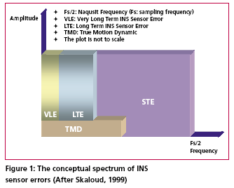
According to Skaloud [1999], the inertial sensor errors are composed of long term errors (low frequency components) and short term errors (high frequency components). Therefore, a conceptual plot of the frequency spectrum of the inertial sensor errors in the measurements can be illustrated as in Figure (1).


 (5.00 out of 5)