|
Learning from the Great East Japan Tsunami and the Accident at Fukushima NPS
|
|
 |
Shunji Murai
|
Professor Emeritus,
|
University of Tokyo, Japan
|
|
During and after the Great East Japan Earthquake and Tsunami, about 20,000 persons died or are still missing, of which 92.5% were victims of the Tsunami. The fourth biggest earthquake plus Tsunami in history swept away 220,000 houses and 18,000 fi shing boats. The control points installed at the sea bottom 130 km offshore near the epicenter showed 24 m horizontal crustal movement to east-east-south and 5 m uplift vertically, while a GPS Station at Ojika, which is located on the coast nearest to the epicenter showed 5.3 m horizontal movement in the same direction and 1.2 m settlement vertically which would be a trigger to generate Tsunami (see Figure 1).
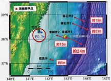
Figure 1: Crustal Movement
Prediction of earthquakes
Using GPS data provided by Geospatial Information Authority (GSI), Japanese Government, the author’s group succeeded to predict earthquakes through the trend analysis of time sequential data. There are about 1,200 GPS Fixed Stations called electronic control points all over Japan as shown in Figure 2. The data derived from these GPS stations can be downloaded free of charge on the Internet.
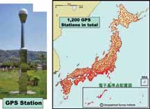
Figure 2: GPS Stations of GSI
Figure 3 shows an example of predictions in the case of Great East Japan Earthquake including the critical pre-signals of 5 weeks, 4 weeks and 3 weeks respectively before the earthquake. A symbol x shows the epicenter. The most critical pre-signals were 3 weeks before the earthquake though the signals weakened afterwards until the earthquake occurred. This behavior of the early signals is interesting but the reasons are still unknown. We observed the possible occurrence of an earthquake before the event but we did not alert the public as we had no authority to do so. But now we are permitted to develop a business that will provide a service on earthquake prediction as a commercial activity.
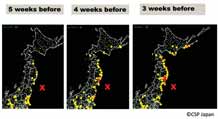
Figure 3: Pre-signals of earthquake with GPS Data
Japan is surrounded by four tectonic plates including the Pacific, Philippines, Eurasian and North American Plates (see Figure 4). Mt. Fiji stands at the junction of Philippines, Eurasian and North American Plates. In the past Mt. Fuji’s eruptions were linked to the giant earthquakes. Therefore Japanese are concern about the possibility of the next eruption of Mt. Fuji in near future. We have only one GPS station on the Pacifi c Plate, which is at Minami Torishima, which did not move much during the Great East Earthquake. Ojika GPS Station nearest to the epicenter showed pre-signals 15 days and 3 days before the earthquake as shown in Figure 5 though the GPS station ceased its operation after the earthquake.
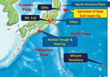
Figure 4: Location of GPS stations of interest
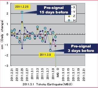
Figure 5: GPS data at Ojika
Early Warning
Early warning is the most difficult task in disaster management. Early warning of the Tsunami had intended to be based on GPS wave height recorder as shown in Figure 6. However, although there were about 15 GPS wave height recorders installed 15 to 20 km offshore along the Pacifi c coast, there was only one Tsunami GPS wave height recorder located 15 km offshore of Kamaishi City near the epicenter, which could record valuable wave form of the Tsunami. It revealed the fi rst occurrence of a 6.6 m high Tsunami 30 minutes after the earthquake and subsequently a total of seven occurrences up to 6 hours afterwards. This would be the fi rst record of a giant Tsunami in the world (see Figure 7). The Tsunami wave offshore will be increased up to about three times (about 20m) as it crosses the coast depending on the sea bottom topography and will fl ow inland up to almost 30 to 40 m above the sea level. Though the GPS wave height recorder is useful to record the Tsunami wave forms, it would not work as early warning system because the Tsunami wave will arrive at the coast within about 5 minutes with the velocity of about 100 km per hour. But the Japanese government is attempting to increase the number of GPS wave height recorders offshore in the Pacific Ocean for early warning.
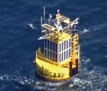
Figure 6: GPS Wave Height Recorder
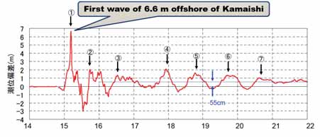
Figure 7: Tsunami Height Record
Preparedness
Preparedness against future earthquakes and Tsunamis are most important in order to avoid a similar catastrophe. Many people tried to escape responsibilities for not preparing for such a disaster by saying that they did not expect such a large Tsunami. Now they cannot avoid being responsible for one of the worst examples of making an incorrect assumption leading to a lack of preparedness. Archaeological excavations have investigated ground layers along the coast lines in Japan to reveal the traces of past giant Tsunamis as shown in Figure 8-1. The Tsunami layers are easily detected from such ground excavations as shown in Figure 8-2. The profi le shows that giant Tsunamis occurred about every one thousand years. According to such records, simulations of Tsunamis have been implemented under an assumption of the three worst cases of giant earthquakes of Nanaki, Tonakai and Tokai, which occurred at the Nankai Trough in 1707 (called Hoei Great Earthquake with Tsunami and the eruption of Mt. Fuji 49 days afterwards). The result of the simulations in this worst case showed that a Tsunami higher than 10 to 30 m would occur along wide areas of the Pacifi c coast as shown in Figure 9. The detail topographic survey of the land portion, as well as the sea bottom are very necessary for the simulations.
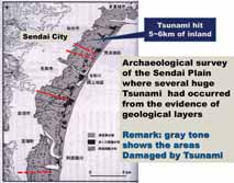
Figure 8: 1 Archaeological excavation
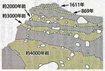
Figure 8: 2 Geological layers showing the past Tsunami
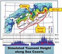
Figure 9: Assumed giant Tsunami
Relocation of residential zones to higher land
Relocation of residential zones to higher ground will be a key point to avoid future devastation and loss of life. However there are many reasons to resist such a plan because some people, particularly fi shermen, like to stay near the sea coast and some others don’t like to leave the mother land. The central government as well as the local governments attempt to relocate towns and villages to higher ground 20 to 30 meters above sea level, though fi shery industries will be allowed to locate near the coast if they prepare good evacuation measures.
We have to learn from past experience of our ancestors who made smart decisions to relocate their residential zones to higher ground. For example Yoshihama fi shermen in Iwate Prefecture relocated their village to higher ground after serious devastation by Meiji Tsunami in 1896 and Showa Tsunami in 1933. Figure 10 shows Google Earth image of Yoshihama Village with houses located on higher ground, where rice paddy fi elds located on the site of the former village were damaged by Tsunami this time. Another example shown in Figure 11 is the case of a small fi shing village called Aneyoshi Village in Iwate Prefecture which suffered badly from the Meiji and Showa Tsunamis when most villagers died except for only a few persons. Those survivors decided to relocate their village to higher ground 60 meters above the sea level. In order to remember such a catastrophe, they constructed a stone monument at the limits of the Tsunami inundation writing “Don’t built any house lower than this stone monument. Don’t forget the past Tsunami and then the villagers will have a happy and safe life”.
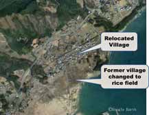
Figure 10: Relocated Yoshihama Village
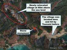
Figure 11: Relocated Aneyoshi Village
One of the diffi culties is to achieve consensus amongst the residents to all move to higher ground by selling their properties in their ‘old mother land’. Nowadays we have only a few cases which have succeeded to gain the approval of the residents and local government. Without such relocation plans, the total city plan could not be progressed. In my opinion it would take more than five years achieve such a decision.
Reconstruction of smart cities
In spite of diffi culties mentioned above regarding relocation of residential zones, a new concept of the “smart city” is being proposed for the reconstruction plan. Smart cities will provide solar energy power systems, high speed communication networks, high rates of recycling, mass transportation systems, selfsupporting water supply and so on. It would be better to construct such smart cities rather than just to renovate original cities. The government is now encouraging such concepts for the reconstruction. Several cities have already proposed smart city construction.
For example Taro District in Iwate Prefecture which was heavily damaged by the Meiji Tsunami in 1896 with a high rate of 80 % of victims amongst the residents is making a new city plan. The District was hit and devastated seriously this time by the Tsunami even though the District should have been protected by 10 m high and 2.4 km long breakwater as shown in Figure 12. But this breakwater called “Taro Great Wall” was unbelievably devastated by Tsunami. Figure 13 shows one of the proposals which include a concept of smart city with solar energy power generation, safe guaranteed residential zones to be relocated on hilly land, highly elevated roads and bridges to assure transportation and rescue, evacuation towers, connecting corridors between buildings and others (see Figure 14).
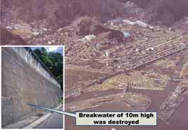
Figure 12: Devastated Taro District
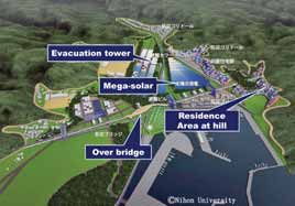
Figure 13 Reconstruction Plan of Taro District
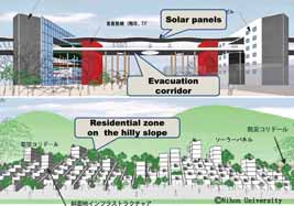
Figure 14: Reconstruction plan
Smart mapping of passable roads
Car travel records in operation with car navigation system with GPS are transmitted to a data center of the car makers. Therefore the data center can make a map showing which individual cars passed which roads and how many times at certain times. This map displays ‘passable roads’. Toyota and Honda car industry provided the passable road map every day to Police Bureau and Defense Agency for rescue purposes after the earthquake and Tsunami. Figure 15 shows a sample of passable roads which indicates that the blue colored roads were updated every day. They were very useful for rescue patrol to reach the devastated areas as well as for the road recovery team to plan reopening of roads. It is interesting to know that an ancient road and several ancient towns constructed about 5 to 6 km far from the sea coast line in the Sendai Plain were not damaged by the Tsunami as shown in Figure 16. The left figure shows the location of the ancient road and towns while the pink color indicates the inundated area of Tsunami. The right fi gure shows a satellite image of the same area. Ancient people might have learned lessons from past experiences of devastation. This is a good example of being well prepared.
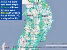
Figure 15: Sample of passable roads
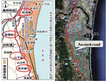
Figure 16: Ancient road and towns
Processing rubble and solid waste
The total volume of rubble and solid wastes is estimated at 24 million tons. According to Japanese regulations, the rubble and solid waste should be treated as industrial deposits which need to be classifi ed into various classes. Therefore it will take time to gather and classify the rubble and solid waste. Ishinomaki City in Miyagi Prefecture was most seriously devastated with about 4,000 victims and six million tons of rubble and solid waste equivalent to the volume of accumulated waste of 106 years. At fi rst thousands of unusable cars should be collected and dumped in a certain area. Other rubble and solid waste are being processed but it takes time and money. Professor Akira Miyawaki, who is a prominent ecologist, is proposing to use the rubble and solid waste as fi lling to construct a high bank instead of concrete breakwater together with environmentally friendly forests to lessen the power of a future Tsunami. The rubble mounds would be strong enough to withstand a Tsunami and protect residential zones behind them as shown in Figure 17. The author is proposing to construct keyhole burial mounds using the rubble and solid waste similar to the keyhole burial mounds of ancient times in the 5th century which were a unique tradition of Japanese religion, and used for an Emperor’s Tomb. The author thinks that we need to construct a memorial for praying for safety and happiness of nations on the occasion of such a catastrophe. The keyhole tomb of Nintoku Emperor constructed in the 5th century is the largest burial mound in the world as shown in Figure 18. The author proposes circular keyhole burial mounds 36 m high and 311 meters in diameter as a memorial of the earthquake and Tsunami which occurred on March 11 – 311- as shown in Figure 19. This burial mounds would become the largest in the world. At least once a year, all relatives of the victims and other related people will be able to join at this park and pray for safety for the future. The keyhole tomb will be surrounded with a green belt and waterways and the surface of the rubble mounds would be covered by soil to allow for plantation of trees on the slopes.
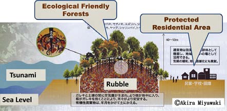
Figure 17: Breakwater with dumped rubble
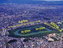
Figure 18: World biggest Keyhole Burial Mounds of Emperor Nintoku made in the 5th century
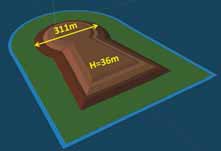
Figure 19: Keyhole Burial Mound with use of rubble proposed by Shunji Murai
Recovery from the accident of Fukushima NPS
The meltdown of nuclear fuel bars at three reactors out of four at Fukushima No. 1 NPS caused a hydrogen gas explosion as shown in a video scene of Figure 20. A satellite image shows the accident after the explosion of No.3 and No.4 reactor (see Figure 21). This human made accident caused the spread of tremendous amount of radioactive radiation equivalent to 30 atomic bombs dropped on Hiroshima in 1945. Without cooling from fresh water supply and sea water circulation, those fuel bars including spent fuel bars heated up to 2,800 degree Celsius which may have caused the hydrogen gas explosion. The reason why we recognize this as a human made accident is that none of experts expected such an explosion and blindly believed in its safety. Tokyo Electric Power Supply Company (TEPSCO) was not at all prepared for such an accident.
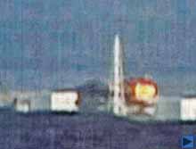
Figure 20: Video scene of hydrogen gas explosion
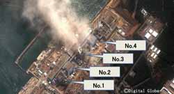
Figure 21: Fukushima No. 1 NPS showing the accident
The radioactive contamination has spread over wide areas even including Tokyo, 250 km away from Fukushima NPS as shown in Figure 22. If you look at the vicinity of Fukushima NPS, access is prohibited for some areas even beyond 30 km (subject to over 50 milli sievert (mSv.) per year) from Fukushima NPS, while some parts more than 50 km away are not livable (over 20 mSv. per year) depending on wind direction as shown in Figure 23.
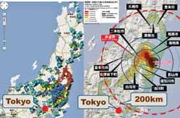
Figure 22: Hot Spots of Radio-active Contamination
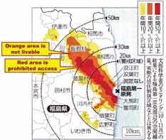
Figure 23: Annual Contamination
A question arises whether there is smart solution to solve the problems caused by such accidents. My answer is that there is no solution. This is because the radioactive radiation will continue almost forever and also we cannot clean up all the contaminated land by stripping off the contaminated surface soils and washing away the contaminated roofs, roads and others. Now local governments are trying to clean up contaminated areas, but they have no idea where such contaminated deposits should be dumped because local people are strongly against locating dumps near their houses. The volume of such contaminated soils is far larger than the capacity of dumping sites.
In addition all food and drinking water should be below the upper limit of radiation for health care to guard against the possibilities of residents contracting various forms of cancer. The governmental standard is; food less than 100 Becquerel (Bq.), milk less than 50 Bq. and water less than 10 Bq. Normal living conditions should prescribe exposure of less than 100 mSv. per year which should be lessened to 10 mSv after 2 years of exposure. The fi nal target will be 1 mSv. per year. People don’t believe governmental actions and they start to measure the radiation themselves to confi rm safety. Moreover the government, as well as TEPSCO, have no idea how to shut down the damaged reactors. They cannot investigate even now the level of the melt down of the nuclear fuels which are located under contaminated water. Only robot arms 40m long would be able to pick up those fuels but nothing is planned yet. It means radioactive radiation will continue to contaminate the vicinity for many years until complete shutdown.
Conclusions
Construction of smart communities would be the best solution for preparedness against future catastrophic disasters. There is nothing absolutely safe in the case of Nuclear Power Stations. Therefore a small country such as Japan which also is disaster prone should not allow construction of any more nuclear power stations in order to ensure sustainable happiness.
Reference
Murai, Shunji; Higher Ground: Learning from the Great East Japan Tsunami and Meltdown at Fukushima NPS, Geomares Publishing, Lemmer, The Netherlands, 2012 |


 (10 votes, average: 4.50 out of 5)


Leave your response!