
A2Z Drone Delivery launches portfolio of drone docks
A2Z Drone Delivery has launched a portfolio of autonomous drone docks and a companion UAV adapted for the system’s automatic charging capability. It offers the unique ability for UAVs to move from dock-to-dock to automatically top off batteries and pick up or deliver packages, infinitely expanding the …
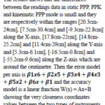
This study aim is to investigate the possibility to used low cost GNSS receiver in the place of those costly one, by appreciating the time of processing data and the coordinates
Benjamin Bahel
Department of Topography and Real Estate Management (HTTTC, Kumba University of Buea, Cameroon) and Laboratory of geotechnology and civil engineering (IUT, Douala University of …
The new EGNOS SoL Service for Aviation SDD introduces several updates designed to improve the precision, reliability, and safety of satellite navigation services in aviation.
One of the standout features in SDD v3.6 is the introduction of updated commitment maps. These maps visually represent the regions where EGNOS commits to delivering a specific level of service performance. The new maps bring significant …
The Commonwealth Secretariat and the Government of Azerbaijan have signed a landmark joint declaration in Tonga aimed at enhancing climate action in Small Developing Island States (SIDS) and other vulnerable member countries.
This historic agreement underscores both parties’ commitment to addressing the urgent challenges posed by climate change, particularly in regions most susceptible to its effects.
As …
SkySat data has been leveraged by the government of the Kingdom of Bahrain’s Survey and Land Registration Bureau (SLRB), to enhance urban planning initiatives nationwide. In collaboration with Planet, Aetosky (formerly known as SkyMap Global) has implemented an advanced urban planning system.This turnkey solution integrates AI-enabled change detection technology with our high-resolution satellite imagery, exemplifying a …
The European Defense Fund (EDF) and the Ministries of Defense of Estonia and Finland have awarded a $6 million investment to Project BadB, a consortium led by KrattWorks, an Estonian defense technology company. The project focuses on developing advanced navigation solutions for land and aerial vehicles that operate independently of GNSS.
Project BadB aims to address …
Inertial Labs has integrated its RESEPI lidar solution into ideaForge UAVs. The integration seeks to improve lidar mapping capabilities and is suitable for mining, forestry, geographic information system (GIS) and land surveys, water resources management and more.
The UAVs equipped with RESEPI offer a vertical accuracy of 2 to 3 cm. The precision is maintained at …
SandboxAQ has released AQNav, designed for navigation across air, land and sea when GPS signals are jammed or unavailable.
As of June 2024, AQNav has logged more than 200 flight hours and 40 sorties across multiple regions of the world on four different aircraft types, ranging in size from single-engine planes to large military transport aircraft.
AQNav is …
Emlid has released upgrades for its ultralight Reach RX Network real-time kinematics (RTK) rover. It features MFi (Made for iPhone/iPad) certification and is fully compatible with ArcGIS, QGIS and other GIS apps for both iOS and Android. Reach RX can be seamlessly integrated into GIS workflows to help industry professionals and teams collect accurate geodata at …


 (5.00 out of 5)