| Navigation | |
Satellite Navigation– Truths & Myths
|
||||
|
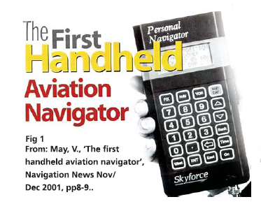
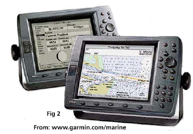
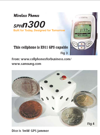
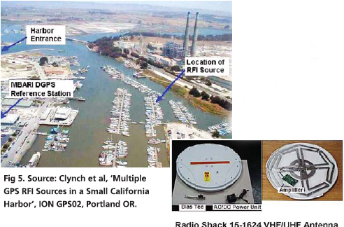
Today’s professional navigators may well be the last. As recently as a generation ago, navigation was almost solely the specialised art of a small number of highly-skilled people. They wore uniforms with emblems on their shoulders. They had years of training.They used complex, expensive, equipment. They bestrode the bridges of ships and the fl ight decks of the large commercial aircraft and took star shots. Then, quietly, a revolution started in the world of navigation. The first phase of the revolution brought lower cost, smaller, higher performance navigation equipment. Amateur sailors and aviators got technology more powerful than professional equipment, and very much cheaper: Decca Navigator and Loran-C sets for yachts, for example (Fig 1 & 2). The second phase of this revolution was driven by GPS. Navigators, the early adopters of satellite navigation, were rapidly followed by surveyors, geodesists, desert travellers – people with at least loose connections to navigation. But then came, farmers,motorists, truckers, people seeking not so much the high peaks of the great outdoors as the delivery bay at McDonalds! Soon, these nonnavigators outnumbered the navigators.Global navigation systems stopped being primarily about navigation; they became simply public utilities. And now we are entering a third phase of this revolution, where the utility that is Global Satellite Navigation becomes universal and largely invisible. The trigger for this phase was the US government’s requirement that cell-phone networks should automatically identify the locations of users who call the emergency 911 number. Many networks chose Assisted-GPS (A-GPS) technology, nearinstantaneous location measurements using a GPS receiver inside the handset, assisted by data passed to it over the cellular system (Fig3). This works, and the networks can now locate their users. Your phone can tell you where you are, download a map for you, guide you to your destination; it can locate the nearest police station, or hospital, pubs for young men and toilets for elderly gentlemen. It can give you tourist information, tell you of traffi c problems ahead. Phones can track your children or your girlfriend, or your boyfriend! Of course, think of the Internet and spam: as you walk down a street, your phone will soon try toentice you into sleazy bars, dubious cinemas, or houses of ill repute! Worldwide, there will be soon be hundreds of millions of new users of global satellite navigation systems, GNSS. Most of them will neither know nor care that they are using a satellite navigation system. Our sophisticated navigation technology will simply have become a location sub-system of a low-cost consumer product. Have navigators, institutes of navigation, or national governments yet come to understand this new reality? Do we not still think in traditional navigation terms, of ships and aircraft alone? Look, for example, at how we are responding to the current threat of the possible loss of satellite navigation. On September 10, 2001, the day before 9-11, the Volpe Report was published. This US government document speaks in clear terms of the risks the US takes if GPS becomes its only means of navigation, or (as it is becoming) the only source of the precision timing that synchronises US telecommunications networks. The risk is partly from interference, unintentional or intentional. Volpe says such interference hazards can be reduced, but never eliminated. And with US transportation relying increasingly on GPS, losing it could cause severe safety and economic damage to the nation, unless those threats are somehow mitigated. The report says that GPS is becoming a tempting target for individuals, groups, or countries hostile to the US. GPS can be denied by jamming, and receivers can even be spoofed into producing hazardous, misleading information. So, the Volpe Report calls for awareness, planning, and supplementing GPS with backup systems in critical applications a tempting target for individuals, groups, or countries hostile to the US. GPS can be denied by jamming, and receivers can even be spoofed into producing hazardous, misleading information. So, the Volpe Report calls for awareness, planning, and supplementing GPS with backup systems in critical applications the satellite signals at 85km. A more sophisticated jamming signal would be effective to maybe 1000km. Such a jammer on the roof of a tall building could stop every GPS across a city: car navigators, tracking systems in taxis and fi re trucks, and receivers in aircraft within line of sight. If the jammer were left on, and perhaps moved occasionally to make it harder to fi nd, it would begin to affect GPStimed telecommunications systems. Cell-phone sites, and telephone and data communications that employ local GPS timing, would gradually drift out of synchronisation and fail. Who would deal with the problem? Would the US Cavalry come riding over the hill? We must ask in each country: who has the equipment to fi nd a civil jammer, the organisation to respond, and the legal powers to enter buildings and search for it? In most countries: no-one. Jamming problems are real. In the harbour of Moss Landing in California, a couple of faulty TV antenna units on boats radiated interference (Fig 5). Every vessel in the harbour, and up to a kilometre out to sea, lost GPS service. So did every vehicle and every individual. A few GPS receivers actually gave false positions. The problem lasted for months until the cause was tracked down by technicallycompetent volunteers. There are millions of such TV amplifi ers across the world. These units are not designed to jam GPS, but their malfunctioning can result in a 3 km jamming range. Imagine a jammer purposebuilt by an expert! GPS jammers have a lot |
||||
|
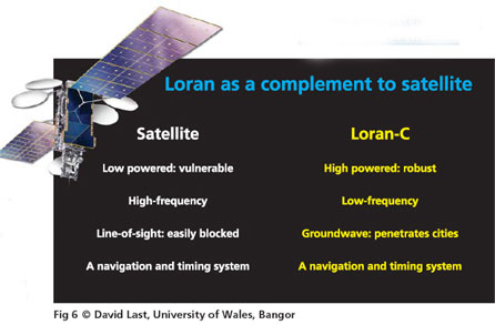
in common with computer viruses. We know about viruses; we live in a world in which a socially-inadequate teenager with acne and no girl-friend, can cause havoc in the Pentagon and panic in the banking system! There are designs for GPS jammers on the Web. Jamming does not take Al Qaeda, it takes a spotty kid in his bedroom. Satellite navigation is like the computer business before the fi rst virus. And we have no McAfee and no Norton! It could get much worse when people really try to stop satellite navigation. Many European countries now plan to charge road users. Motorists hate the idea, just as they hate radar speed traps. A jammer in a motorist’s car could disable GPS road user charging across a city – and at the same time disable GPS for the rest of the population. Who would track it down? How long would that take? That is the potential problem. The response of each nation tells us a lot about whether they have woken up to the new satellite navigation world. Initially, the UK and other countries, responded to the threat of losing GPS by stating that they required multiple navigation systems for aviation and shipping – the traditional navigation applications. These are indeed safetycritical areas, and governments have responsibilities for them. But there is no sense here of governments recognising the role satellite navigation is now playing in their economies. What about telecommunications timing, mobile phone users and their emergency calls? The UK and other countries are saying that these millions of new users (perhaps 96% of the market) are not critical and do not really need satellite navigation. If there is a GPS problem, they can just go back to doing what they did before. But they no longer can! Of course, we could lose our car navigators. But whole swathes of industry and commerce have committed to the cost savings and efficiency benefits offered by GPS. Our telecommunications rely on it totally. It is simply too late to go back to what we did before.People do not maintain their old systems alongside the new and pay for both! A recent European report showed that fewer than 40 of 137 GPS applications would remain operational if GPS were lost. So as we commit to the widespread dependence A leading candidate, suggested in the Volpe Report, is Loran-C, especially the new Enhanced Loran (eLoran). Loran is a terrestrial system with transmitters of hundreds of kilowatts operating at the low frequency of 100kHz. It is in place across all the US and much of Europe and Asia. The strengths and weaknesses of Loran (Fig 6) are very different from those of GPS. GPS is vulnerable to interference because the distant satellites deliver so little power to our receivers. Loran, with its megawatt stations and tall transmitting antennas, is at least 10,000 times harder to jam. Then, microwave signals from satellites and lowfrequency signals from Loran prevent single-point failures. On land, where buildings and mountains block GPS signals, Loran travels along the earth’s surface, deep into city centres, even into buildings. Like GPS, eLoran is a complete navigation and timing system. Integrate them together in a single receiver (Fig 7), and eLoran will take over seamlessly when GPS fails. eLoran in that mode, like GPS, works with an accuracy of metres; it delivered harbour entrance accuracy of better than 10m in recent UK trials. Loran has recently been modernised right across the US to act as a backup to satellite navigation and Europe has to decide whether to do the same. Both the US and Europe will shortly set out their future polices on eLoran. Many Europeans, though, believe that there is a different solution to the problem of GPS vulnerability: Galileo. The European Commission says:“Galileo will be far less vulnerable than GPS, so eliminating most concerns expressed in the Volpe report … because Galileo will use a variety of different and separate frequencies. Why is Europe is producing a GPS look-alike? Like GPS, Galileo will be a Global Navigation Satellite System. It is broadly similar to GPS, using the same principles and radio frequency bands, so our receivers GPS started life as a US Air Force“weapons aiming system and force enhancer”, and though it now has both military and civil roles, at times of crisis the US military requirement always prevails. Galileo was a wholly civil concept; but gradually questions of its possible military role have emerged, and are now a hot topic. GPS belongs to a single nation, and the rest of us use it on terms that suit US interests. Galileo belongs to the many nations of the European Community who have sought the active participation of other nations. There are important technical differences between the two systems: frequencies, codes, time standards, modulations, and geodetic frameworks. GPS is free of charge. With Galileo, the user pays for additional services. One is run by the military, the other is to be a public-private partnership. And, of course, GPS is a mature system, the fi rst satellite launched in 1978, a stunning success. Galileo is still essentially a proposal; only the first test satellite has yet been launched. The first true Galileo satellite will be a full 29 years behind GPS! Tensions between US military control of GPS and its growing civil use led to the imposition of Selective Availability (SA), the intentional reduction of the accuracy available to civil users. Despite SA, civil GPS use fl ourished, and Differential GPS (DGPS) was developed to give high accuracy (Fig 8). In DGPS, a receiver at a differential reference station measures where GPS says it is. It knows where it truly is, so it can compute and broadcast corrections for the GPS errors to users in the region, who apply them and so get metrelevel or better accuracy. The US Coast Guard were pioneers of DGPS. So, by the mid-90s we had the bizarre situation that the US government had spent some $20 billion creating a highly-accurate navigation system, millions more to deny that accuracy to most of the users, and was spending yet more on DGPS. This not only defeated SA, but actually gave civil users higher accuracy than the military GPS that SA was there to defend! |
|||||||||||||||
|
|||||||||||||||
|
Pages: 1 2



 (No Ratings Yet)


