| Mycoordinates | |
Role of Photogrammetry and Remote Sensing in Wenchuan Earthquake
|
Deren Li
|
||||
|
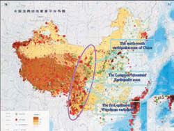
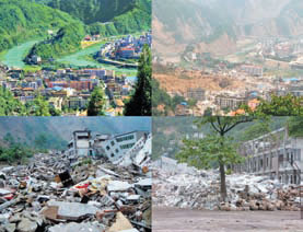
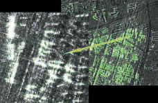
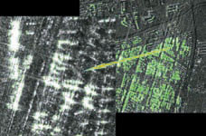
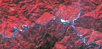
An earthquake, measured 8.0 on the Richter scale, struck Wenchuan County, Sichuan Province at 14:28 on May 12, 2008. The epicenter was at Yingxiu, a town in Wenchuan, as shown in Figure 1. As indicated in Figure 1, the middle segment of the Longmen Mountain earthquake zone encloses the epicenter, Yingxiu, with the Longmen Mountain zone Figure 1. The Wenchuan earthquake in context In Wenchuan earthquake, the worst hit areas include Beichuan and Qingchuan, with the earthquake intensity measured at 11, with the maximum being 12 by the Chinese seismic survey standards. By 12:00 pm on June 14, 2008, the death toll read 69,170, with 374,159 people injured, 17,428 people missing,and a population of 48,270,000 severely affected by this huge disaster. Figure 2 shows the beauty of Beichuan before the earthquake against the destruction and devastation after the earthquake. Figure 2. Pictures showing Beichuan before and after the earthquake. Figure 3. Aerial photography flown with ADS40 (GSD: 0.3 m) showing what was left of Yingxiu Town in Wenchuan after the earthquake on May 15, 2008. Figure 4. The image acquired by Cosmo (at a resolution of 1 m) indicating the locations (white segments) where buildings are likely collapsed after the earthquake; up to 14.8% of the areas were suspected to be results of collapsed buildings. Figure 5. The change of river water ways due to the forming of quake lakes in Tangjiashan, as indicated by white regions generated by comparing SPOT5 (10 m resolution) images taken before (November 10, 2006) and after (May 16, 2008) the earthquake. Figure 6. The DEM of the quake lake in Tangjiashan, Mianyang city, Sichuan Province, one of the area worst affected by Wenchuan earthquake, which was generated based on ALS50 II air-borne LiDAR data with a sampling interval of 2 m, flight date, May 31, 2008, by the State Bureau of Surveying and Mapping, Wuhan University, and Wuda Geo Information Company (the barrier dam is shown with a inset picture) |
||||
|
Deren Li
|
||||||||||||
|
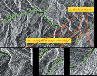
Phase II was marked by the prevention of and preparedness for secondary disasters, i.e., landslides and mudslides, especially, those in and around the quake lakes or barrier lakes. Figure 5 clearly highlights the change of river water ways due to the forming of quake lakes in Tangjiashan, as indicated by white regions generated by comparing SPOT5 (10 m resolution) images taken before (November 10, 2006) and after (May 16, 2008) the earthquake. Figure 6 shows the DEM of the quake lake in Tangjiashan, Mianyang city, Sichuan Province, one of the area worst affected by Wenchuan earthquake, which was generated based on ALS50 II air-borne LiDAR data with a sampling interval of 2 m, flight date, May 31, 2008, by the State Bureau of Surveying and Mapping and Wuhan University (the barrier dam is shown with an inset Figure 7. The boundaries of rivers in the quake lakes, Tangjiashan, Mianyang city, Sichuan Province, as indicated by the green lines against the background Radarsat imagery at a resolution of 7 m, acquired on May 17, 2008. In addition to disaster relief efforts, D-inSAR can also be used for scientific research on earthquake. Preliminary results derived from ALOS PALSAR satellite acquisition on June 11, 2008 are released at www.gmat. unsw.edu. au/LinlinGe/ Earthquake, as shown in Figure 8, thanks to the efforts of the team led by Dr Linlin Ge. Dr Ge used predicted orbit data in order to produce and deliver the result in NEAR REAL-TIME: 17 hours and 46 minutes, from image capture to results posting on web. The Japanese ALOS PALSAR sensor acquired the Path Figure 8. The image showing the aftershocks, generated by D-inSAR technology based on ALOS PALSAR sensor acquisition, Path 477 image on 11 June 2008 1:37 Sydney Time AEST. Some concluding remarks are as follows. It has been demonstrated that photogrammetry and remote sensing has played a crucial role in the aftermath of the earthquake in Wenchuan, Sichuan. The rapid data acquisition and information services, especially, those featured with fully automatic, near realtime remote sensing systems without ground control, have contributed greatly to the rescue work and disaster relief AcknowledgementsMany institutions and people have helped with data acquisition and provision of materials during the project concerning rapid response to Wenchuan earthquake. The diligent work by and kind helps from colleagues home and abroad are gratefully acknowledged. |
||||||||||||
|
||||||||||||
|
Pages: 1 2




 (No Ratings Yet)


