| GNSS | |
Offshore application of EGNOS
Steve Leighton
|
|||||||||||||||
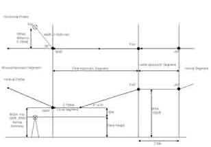
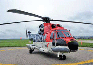
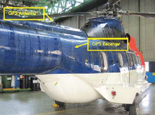
Flight simulationsAs part of the design process for the SOAP approach, a set of simulation trials were carried out in order to determine the optimum values of certain parameters in the procedure description and evaluate its overall flyability. These trials were carried out in the Eurocopter SPHERE facility, in Marignane, France. The pilots involved included representatives from various different offshore operators. The SOAP procedure was flown in the simulator using different values for the Minimum Decision Range (MDR), descent slope, maximum offset angle between the final approach track and the track from MAP to rig, and final horizontal and vertical airspeeds. These were tested against different wind directions and speeds, and a visual range slightly above the MDR value. The primary results from the simulation trials were that the final visual approach and deceleration towards the rig is the most critical of the procedure, and must be at least 0.75NM for a final groundspeed of 80kts, but could be reduced to 0.5NM for a groundspeed of 60kts. It was agreed that a glideslope of 6° was too steep at a groundspeed of 80kts, and that at this speed 4° should be the maximum. A maximum offset angle of 30° was agreed, with 45° making it hard to establish visual contact in the difficult visual conditions. Also tested was the presentation of the vertical guidance provided to the pilot. Some pilots preferred the ‘Procedural guidance’ [Figure 3] in which an ILSlike glideslope beam was provided during the descent but not during the level segment, whereas others preferred the ‘Full ILS-like guidance’ [Figure 4] in which a linear vertical deviation scale was provided on the level segment in addition to the ILS-glideslope. Overall the trials were deemed to be successful and of sufficient quality that the results were used to finalise the approach procedure as described above. Flight trialsThe Geostationary satellites broadcasting the SBAS correction message appear at a low elevation angle at the Northerly latitudes of many of the oil platforms Figure 2 Figure 3 Figure 4 Figure 5 where the helicopters will be operating. When coupled with the potential occurrence of signal masking by the airframe of the helicopter itself, and sub-optimal antenna location, visibility constraints could be significant barriers for EGNOS usage. To assess the practical impact of these parameters the GIANT project undertook a helicopter flight trial to investigate the signal availability of EGNOS under representative conditions. The trial platform was a Eurocopter AS.332L Super Puma operated by CHC Scotia helicopters out of Aberdeen [Figure 5] and is a typical aircraft that works in the North Sea environment. The trial took place near Aberdeen airport in Northern Scotland. At this latitude the three EGNOS geostationary satellites are at a very low elevation angle to the South. The helicopter had a typical GNSS antenna installation that is currently used as an input to a Canadian Marconi CMA3012 GPS receiver that in turn provides position input to the aircraft Flight Management System (FMS). For the purposes of the trial the aircraft’s own antenna was used. The location [Figure 6] is on the tail boom, just above the rear of the passenger cabin. There was expected to be clear airframe masking from the main cabin and engine assembly ahead, as well as possibly from the tail itself to the rear. This was expected to fully obscure reception of SBAS Geo signals in a 70° arc ahead of the antenna. The objectives of the trial were to examine the extent to which airframe masking impacts SBAS satellite reception as well as the practical implications of real world antenna installations on EGNOS performance. To this end a Septentrio PolaRx2 SBAS capable data logging receiver was installed on board the helicopter connected to the main antenna. This was configured to receive all SBAS satellites in view. Data was also logged through the helicopter’s own flight data recording system so that aircraft attitude parameters were available. During the trial the aircraft undertook a series of orbits at constant bank angles and altitude. The objective being to record data on the practical masking effect on the visible SBAS geostationary satellites. It was found that engine masking caused the receiver to sequentially lose lock on the three satellites during periods where the helicopter’s heading moved through due South. Whilst the period of total SBASsignal loss was only about 20 seconds in each case, the individual satellites were each obscured for up to 100 seconds. In the operational EGNOS space segment of only two satellites this could present a risk. The horizontal and vertical protection levels calculated by the receiver were well within the requirements for APV approach procedures whilst SBAS satellites were in view. However there were notable spikes in the protection levels during periods where no SBAS satellites were being tracked. These spikes would have exceeded alarm limits for APVII, LPV200 and APV-I approaches. Finally a number of representative SOAP-like approaches were undertaken to the four compass headings to allow the collection of data on the practical performance of EGNOS under representative flight dynamics. The constant heading meant that there were no periods in which SBAS-tracking was completely lost, and as such the protection limits were always within APV-II alert limits. As expected flying the approach in a southerly direction caused significant constraints to the visibility of the GEOs, whilst the northfacing approach saw all three satellites being consistently tracked. Surprisingly, it was found that when flying the approach East or West only the AOR-E satellite was consistently in view. It is possible that this was due to the low antenna gain characteristics at low elevation angles resulting in successful tracking of the highest elevation satellite only. The flight trials clearly show that in certain situations the orientation of the helicopter can cause the receiver to lose track of all SBAS satellites, denying it the guidance required to perform APV approaches. Whilst the current antenna position is well suited to providing an input for the GPS navigator, to support SOAP operations it would ideally be relocated or else augmented with a second antenna to reduce the effect of airframe masking. Figure 6 ConclusionsThe GIANT project has been pushing ahead with the necessary activities to make EGNOS a viable navigation system in the hazardous North Sea environment. Procedure development, flight simulations and flight trials have all contributed to the development of SOAP helicopter approaches and will feed into a potential future implementation process. |
|||||||||||||||
|
|||||||||||||||
|
Pages: 1 2


 (2 votes, average: 3.00 out of 5)


Leave your response!