NEWSBRIEFS – Remote Sensing
May 2008 | Comments Off on NEWSBRIEFS – Remote Sensing
|
|
|
|
|
|
|
 |
|
|
India’s leap into space
On April 28, 2008, ISRO’s Polar Satellite Launch Vehicle, PSLV-C9, successfully launched the 690 kg Indian remote sensing satellite CARTOSAT- 2A, the 83 kg Indian Mini Satellite (IMS-1) and eight nanosatellites for international customers into a 637 km polar Sun Synchronous Orbit (SSO). PSLV-C9 in its ‘core alone’ configuration launched ten satellites with a total weight of about 820 kg. |
|
|
CARTOSAT -2A
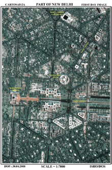
CARTOSAT-2A is a state-of-the art remote sensing satellite with a spatial resolution of about one metre and swath of 9.6 km. The satellite carries a panchromatic camera (PAN) capable of taking blackand- white pictures in the visible region of electromagnetic spectrum. The highly agile CARTOSAT-2A is steerable along as well as across the direction of its movement to facilitate imaging of any area more frequently. Soon after separation from PSLV fourth stage, the two solar panels of CARTOSAT-2A were automatically deployed. The satellite’s health is continuously monitored from the Spacecraft Control Centre at Bangalore with the help of ISTRAC network of stations at Bangalore, Lucknow, Mauritius, Bearslake in Russia, Biak in Indonesia and Svalbard in Norway. High-resolution data from CARTOSAT-2A will be invaluable in urban and rural development applications calling for large scale mapping. |
|
|
Indian Mini Satellite (IMS -1)
Indian Mini Satellite is developed by ISRO for remote sensing applications. It incorporates many new technologies and has miniaturised subsystems. It carries two remote sensing payloads – A Multi-spectral camera (Mx Payload) and a Hyper-spectral camera (HySI Payload), operating in the visible and near infrared regions of the electromagnetic spectrum. The spatial resolution of Mx camera is 37 metre with a swath of 151 km while that of HySI is about 506 metre with a swath of about 130 km. The data from this mission will be made available to interested space agencies and student community from developing countries to provide necessary impetus to capacity building in using satellite data. The versatile IMS-1 has been specifically developed to carry different payloads in future without significant changes in it and has a design life time of two years. |
|
|
Nano Satellites for International Customers
Eight Nanosatellites from abroad are carried as auxiliary payloads besides IMS-1 as well as CARTOSAT-2A. The total weight of these Nanosatellite payloads is about 50 Kg. Six of the eight Nanosatellites are clustered together with the collective name NLS-4. The other two nanosatellites are NLS-5 AND RUBIN-8. NLS-4, developed by University of Toronto, Canada consists of six nano-satellites developed by various universities. Two of them – CUTE 1.7 and SEEDS – are built in Japan, while the other four – CAN-X2, AAUSAT-II, COMPASS-1 and DELPHI-C3 are built in Canada, Denmark, Germany and the Netherlands respectively. The 8 nanosatellite are built to develop nano technologies for use in satellites as well as for the development of technologies for satellite applications. On April 29, 2008, the Multispectral camera onboard IMS-1 was switched on and high quality imagery covering Allahabad to Rameswaram was obtained. On April 30, 2008, the Hyper Spectral Imaging (HySI) camera onboard IMS-1 and panchromatic (PAN) camera onboard CARTOSAT-2A were switched on. Imagery from HySI camera covered Uttarakhand to Karnataka passing through Delhi and Bhopal. PAN camera covered strips of land from Saharanpur to Nuh (South of Delhi) and Sangli to Goa Coast. Data was received at National Remote Sensing Agency (NRSA), Shadnagar, Hyderabad. Quality of the imagery received is excellent. http://www.isro.gov.in |
|
|
Prime Minister congratulates Team ISRO
High quality imageries acquired immediately after the launch of Cartosat-2A and Indian Mini Satellite-1 (IMS-1) were presented to the Prime Minister, Dr. Manmohan Singh at Delhi by Dr. G. Madhavan Nair, Chairman, ISRO along with a team of senior scientis The Prime Minister was highly appreciative of the success of the PSLV-C9 mission which placed 10 satellites into orbit. He congratulated the entire team for the magnificent performance. The Prime Minister was also briefed about ISRO’s missions of the immediate future like Chandrayaan-1 and new initiatives related to the Manned Spaceflight Programme. The Prime Minister wished ISRO team success in all its future endeavours. |
|
|
|
|
|
|
|
|
|
|


 (No Ratings Yet)


