| Positioning | |
Meeting the demands of real-time positioning
|
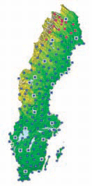
SWEPOS™ is a network of GPS/GLONASS reference stations which began as a co-operation between the National Land Survey of Sweden and Onsala Space Observatory. The early design phases of SWEPOS were made in 1992. It was already then stated that the network should be of both scientific and practical benefit to the professional GNSS users and the public. The purposes of SWEPOS are mainly to [1]: • Provide GNSS raw data to post-processing users • Provide GNSS corrections to real-time users • Act as high-precision control points for GNSS users • Provide data for scientific studies (e.g. crustal motion) • Monitor the integrity of the GNSS systems • Act as the basis for the Swedish national reference frame, SWEREF 99 Figure 1: The SWEPOS network with 161 permanent reference stations for GNSS. The red dots in northern Sweden are planned SWEPOS stations. During early stages of development, SWEPOS consisted of 21 stations covering the whole of Sweden with an average in-between distance of 200 km. During this period a group of governmental agencies contributed to the financing of SWEPOS. Since 1999, SWEPOS has developed to meet the demands on real-time positioning with centimetre accuracy, mainly through co-operative efforts by the National Land Survey, Onsala Space Observatory and the SWEPOS users. Today both the development and operation of SWEPOS are the responsibilities of the National Land Survey. Design of the SWEPOS networkAll 161 SWEPOS stations are equipped with dual-frequency GPS/GLONASS receivers and choke-ring antennas of Dorne Margolin design. The GNSS antennas are mounted under clear acrylic radomes. Data is collected every second, using a 5 degree elevation mask. The stations are connected to a control centre located at the head quarters of the National Land Survey (in Gävle, Sweden) via leased TCP/IP connections, which are monitored at all times. The original 21 SWEPOS stations, which are all still in use today, are mounted with concrete pillars directly on bedrock. These belong to so called SWEPOS Class A stations (blue squares in figure 1), along with 9 newer stations with similar monuments in terms of stability. All equipment, apart from the antenna, is redundant and located in specially designed cabins (figure 2). The remaining 131 stations have mainly been equipped in a simplified way, with antennas mounted on rooftops (figure 3) and with less redundancy. These stations belong to SWEPOS Class B stations (blue dots in figure 1), which were established primarily for the use of network RTK. A complete network computation of all SWEPOS stations is done on a daily basis with the Bernese GPS Software, in order to monitor the stability of the Class B stations. A broad spectrum of Swedish organizations uses GNSS data from the SWEPOS network to increase productivity and efficiency in their respective fields, covering both scientific and production work. Examples of scientific applications include studies of crustal motion and estimations of the water vapour content inthe atmosphere. The SWEPOS positioning services, however, are mainly targeted at production applications (e.g. see figure 4). SWEPOS and EUREF/IGSThe National Land Survey and Onsala Space Observatory have been active in international GNSS projects for many years. The European countries have collaborated in building up a network of permanent GNSS stations as well as in computing national realisations of the adopted European three dimensional reference system ETRS 89. This work is done under the IAG Sub commission for Europe (EUREF). EUREF is also engaged in the establishment of a common vertical reference system based on the national levelling networks and the European GPS campaign EUVN. The realisation of ETRS 89 in Sweden is called SWEREF 99 and is defined by the original 21 SWEPOS Class A stations [2].The SWEPOS stations Visby, Onsala, Borås, Mårtsbo, Vilhelmina, Skellefteå and Kiruna are included in the European network of permanent reference stations (EPN) and the International GNSS Service (IGS). These stations are also participating in the pilot projects for real-time distribution of GNSS data over the Internet – EUREF-IP and IGS-RTPP. SWEPOS positioning servicesSWEPOS provides GNSS data for the following positioning services: • SWEPOS Automated Processing Service • SWEPOS Network RTK Service • SWEPOS Network DGNSS Service • The DGPS service Epos (operated by Teracom) SWEPOS Automated processing serviceSWEPOS Automated Processing Service2008has been developed in order to facilitate the use of SWEPOS data for automatic high-precision static point positioning. The user does not have to perform the computation in a post-processing software himself/herself. Instead the Bernese GPS Software and an in-house developed web application on the SWEPOS web site are used for the computations. The user submits an observation file containing dual frequency data along with information about the used GNSS antenna in RINEX format to the service. When the processing is completed (typically after 5-10 minutes) the web page is updated and a text file with a summary of the processing along with quality parameters is sent to the user by e-mail. From 2-3 hours of observation time, centimetre level accuracy for both horizontal and vertical components can be obtained. Typical applications for SWEPOS Automated Processing Service are computations of reference positions for single-base RTK or terrestrial measurements and connection of various local (municipal) reference frames to the Swedish national reference frame. Further development of the processing service is under way, especially to meet the demands from construction projects with high-accuracy surveying over short time spans. This includes optimizing processing algorithms for a dense reference station network. |
Pages: 1 2


 (No Ratings Yet)


Leave your response!