| Positioning | |
Measuring effects of mining on surface structure
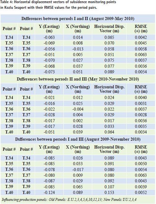
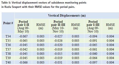
Mining activities create gaps inside the ground. These gaps withstand the load over it by vaulting inside the ground and prevent caving-in as long as they are opened deeper into the ground and remain in smaller proportions, as is the case in mining galleries depending upon the production length. With the mining production gaps reaching larger dimensions, however, the ground just above the gaps starts to collapse by layers breaking away and fills up the production gaps. The movements of the ground on the surface triggered by the collapse of cascading internalground layers are termed as mining subsidence (Kratzsch, 1983; Kuşçu,1991; Perskiand Jura, 2003; Deck et al., 2003; Duzgun, 2005; Akçın et al,. 2006; Saeidiet al., 2009; Can et al., 2011a, 2011b). These movements cause deformations on the earth surface and in the affected ground layers and disruptions on the naturalbalance of ground. As a consequence of this, engineering structures inside the affected ground and on the earth surface above the subsidence region either accommodate to these deformations or sustain damages. These damages, whether they occur on naturalor manmade structures, by means of mining subsidence are called mining damages. Mining subsidence as a result of mine productions underneath the settlement areas, especially in Western European countries where underground coal mining is of great value, has been long a crucial mining issue with economic, social, technical and environmental aspects. In Zonguldak Kozlu Hard Coal Region, coal seams dip mostly at high angle and their thickness is not uniform, therefore mining subsidence problems are most likely to occur causing serious problems with regard to urbanization. This study details the precise leveling and Global Positioning System (GPS) monitoring results for the Kozlu Seaport to determine the mining induced horizontal and vertical displacements. Monitoring of mining subsidenceIt is necessary to gather information on generaland regional properties of subsidence formation and effective constituents which eventually cause damages on structures in order to mitigate mining subsidence induced issues and to provide solutions. Therefore it is of great importance that subsidence measurements and observation should be conducted on the earth surface and, if necessary, in the underground. Even though the mining activities have been going on for 160 years in Zonguldak Hard Coal Basin, there exists little or no knowledge of this, which is needed dearly today especially with the densification of settlement areas just above the old coal production galleries and mining activities continuing under new settlement areas. The coal seams in Kozlu production region have steep inclinations as is generally the case in Zonguldak Hard Coal Basin and the subsidence occurring in this region have adverse effects on social, economic and legal aspects of life (Turer 2008). Figure 1 depicts the subsidence formation and its influence areas after mining activities in inclined coal seams in the region. In times when the main source of energy was coal in a region, much of the effort was spent on obtaining coal reserves under the settlement areas with less production losses and subsidence damages as much as possible. This naturally gave way to important work and research for maintaining this purpose and then to the birth of a discipline called subsidence engineering, which is specialized in five topics as follows (Kuscu,1991): • Subsidence measurements • Subsidence estimations • Subsidence damages • Subsidence control • Subsidence related laws and regulations. In order to determine the subsidence occurring due to mining activities in an underground mine production region, subsidence measurements are utilized to ascertain: • Subsidence parameters (critical and limit angles, displacement values, etc.) • Relationship between subsidence and geology, tectonics and topography • Relationship between subsidence, and production speed and time • Relationship between subsidence and production method. Features of Kozlu coal production regionKozlu-Zonguldak Hard Coal Basin is a formation of the Late Plaeozoic–Mesozoic Age, consisting of various faults and topographic irregularities along the North Anatolian Mountain Range. The town of Kozlu within the Zonguldak Hard Coal Basin was established in 1941 and has a coal production rate of 780,000 ton per year, along with 3.3 million ton per year in the whole basin (URL1 2011; URl2 2011). Kozlu is located in the Western Black Sea Region of Turkey at latitudes 41°–27′ N and longitudes 31°–49′ E (Citiroglu and Baysal, 2011). It borders city of Zongul dak to the northeast, Ereglito the southwest, Caycuma to the east and Devrek to the southeast. The coastline forms the north–northwest boundary of the study area (Figure 2a and 2b). Kozlu is divided into 7 districts, namely Merkez, Tasbaca, Ihsaniye, Kilic, 19 Mayis, Güney and Fatih. The settlement of Kozlu is completely surrounded by mountainous areas. The streams within the study area include Kozlu Stream and its branch Kilic Stream (Ekinci, 2005). Zonguldak-Kozlu- Kandilli(West Hard Coal Basin) is situated to the west of the Filyos River. The Carboniferous clastic sequence of Zonguldak basin contains several coal seams that have been mined since 1848 by underground methods. Coal seams are located in a Namurian to Westfalian D progradational delta and fluid plain sequence that is approximately 3,500 mt thick (Karacan and Okandan, 2000). These units are affected by Hercynian orogenic movements. Related tectonism and uplift led to widespread erosion. Geometrıcalpropertıes of mınıng panels affectıng Kozlu seaportThe coal seams under the engineering structures focused on in this study have steep inclination angles, and they house production panels working on longwall method. Figure 3 demonstrates Ikonos satellite images containing old and new production panels just under the Kozlu Seaport with active and residual subsidence effects. Table 1 lists the geometricalproperties of panels in the Kozlu Seaport region such as opening year, inclination, thickness and width, and Table 2 depicts the maximum possible subsidence magnitudes and parameters computed in accordance with the Subsidence Engineering Handbook of National Coal Board (NCB). Table 3 lists the computed semi-major and –minor axes values of an ellipse enveloping possible subsidence affected areas of old and new production panels in Kozlu Seaport under residualand active subsidence effects for plotting purposes Precıse levelıng and GPS measurements ın Kozlu seaportIn order to determine subsidence magnitudes in the aforementioned region just under the engineering structures, three periods of precise leveling and GPS measurements were conducted in August 2009, May 2010 and November 2010. The one hour static GPS data were collected at the subsidence monitoring points with an observation epoch of 2009.58 in the first period, 2010.40 in the second period and 2010.90 in the third period, avoiding any multipath creating surroundings (Mekik and Can 2010). This study focuses on the subsidence monitoring measurements carried out only in the Kozlu Seaport sections of an extensive research enveloping the whole region (Can, 2011a,b). Table 4 lists horizontaldisplacement vectors of subsidence monitoring points T34, T35, T36, T37, T38, T39 and T40 in Kozlu Seaport. Figures 4 depicts Ikonos satellite images containing horizontal displacement vectors obtained using the three periods of GPS measurements on the subsidence monitoring points in Kozlu Seaport. It is hard to imply that horizontal displacements have caused any visual deformations or functional defects in the seaport during the three periods of GPS and precise leveling measurements in the region. As for the vertical displacements, Tables 5 lists the findings obtained from the three period pairs of precise leveling measurements for Kozlu Seaport. Figures 5 depicts Ikonos satellite images containing vertical displacement vectors obtained using the three periods of precise leveling measurements on the subsidence monitoring points in Kozlu Seaport. Similar to horizontal displacements, it has not been observed that the vertical displacements resulted from residual and active subsidence effects have caused any visual deformations or functional defects in the seaport during the three periods of precise leveling measurements in the region. ConclusionsKozlu mining production region with extensive mining activities houses, many crucial engineering structures, such as Kozlu Seaport, which are the core of this study and there are plans for new constructions on daily basis in the region. In order to maintain the mining operations along with urban developments in a healthy way, the subsidence monitoring measurements and observations play an important role in mitigating or even preventing the damages that possibly will occur in future and in giving way to desired urban development in the region. In the study, it has been determined that the horizontal displacements in Kozlu Seaport vary from 8.0cm to 15.3cm with their RMSE values of 3.9 mm to 6.3 mm, respectively, obtained from the GPS measurements between the periods of i(Aug 2009) and IIi(Nov 2010). On the other hand, the vertical displacements obtained from the three periods of precise leveling measurements have been found to deviate from 6.0 cm to 9.7 cm in the seaport region with 3.0 and 4.0 mm RMSE values. Since the mining operations under Kozlu Seaport and Road will also be active in the future, in the light of the findings obtained from this study, it is suggested that an extensive subsidence monitoring measurements with longer periods should be carried out to mitigate and even prevent functional problems that may arise in these engineering structures in the future. AcknowledgementThis study was funded by Bulent Ecevit University, Scientific Research Projects Unit (2009-45-05-02). The authors would like to express their gratitude to Bulent Ecevit University for their financialsupport. The authors are gratefulto the Turkish Hard Coal Enterprise for its assistance. ReferencesAkçın H, DegucciT, and Kutoglu S H.: Monitoring Mining Induced Subsidence Using GPS and InSAR, TS 48 – Engineering Surveys for Construction Works Ii, XXIIiFIG Congress, October 8-13, Munich, Germany. (2006) Can, E., Mekik, C., Kuşcu, S. and Akçın, H.: Subsidence Occurring in Mining Regions and A Case Study of Zonguldak-Kozlu Basin, Scientific Research and Essays, 6 (6): 1317-1327. (2011a) Can, E., Mekik, C., Kuşcu, S.: Determination of Underground Mining Induced Displacements Using GPS Observations in Zonguldak-Kozlu Hard Coal Basin, International Journal of Coal Geology,(89) pp.62-69 doi: 10.1016/j. coal.2011.08.006,(2011b). Citiroglu, H. K. and Baysal, G.: Effects of Geologicaland Hydrological Factors on the Creation of Flooding in Kozlu, Zonguldak, NW Turkey. International Journal of the Physical Sciences Vol. 6(6), pp. 1360-1373, (2011). Deck, O., Marwan H. A. and Françoise H.: Taking the Soil–Structure Interaction Into Account in Assessing the Loading of a Structure in a Mining Subsidence Area. Engineering Structures, 25(4), pp 435-448, (2003). Duzgun, H.S.B.: Analysis of Roof Fall Hazards and Risk Assessment for Zonguldak Coal Basin Underground Mines. International Journal of Coal Geology, 64(1-2), pp.104-115,(2005). Ekinci, D.: Erosion analysis of Kozlu River basin with the GISbased a modified Rusle Method. IU Geography Bulletin 13, 109–119,(2005). Karacan, C.O. and Okandan, E.: Fracture/ Cleat analysis of coals from Zonguldak Basin (Northwestern Turkey) Relative to the Potential of Coal bed Methane Production, International Journal of Coal Geology, 44 (2): 101-186,(2000). Kratzsch H.: Mining Subsidence Engineering, Springer Verlag Berlin Heidelberg, New York, 111s,(1983) Kusçu Ş.: Mining Subsidence Monitoring and the Importance of Subject in Zonguldak Coal Region In Turkey, InternationalSymposium on Engineering Surveys, FIG, 16-20 September, Sofia, Bulgaria, p. 225-236, (1991) Mekik, C. and Can, O.: An investigation on multipath errors in realtime kinematic GPS method. Scientific Research and Essays, 5 (16), pp.2186–2200, (2010) PerskiZ and Jura D.: Identification and Measurement of Mining Subsidence with SAR Interferometry Potentials and Limitations, Proceedings, 11th FIG Symposium on Deformation Measurements, Santorini, Greece,(2003) Saeidi, A., Deck, O.,,Verdel, T.: Development of Building Vulnerability Functions in Subsidence Regions From EmpiricalMethods, Engineering Structures 31(10), pp 2275-2286, (2009). Turer D, Nefeslioglu H A, Zorlu K, and Gokceoglu, C.: Assessment of Geo-EnvironmentalProblems of the Zonguldak Province (NW Turkey), EnvironmentalGeology, 55(5): 1001-1014. (2008) URL1.: Kozlu Municipality web page. http://kozlu.bel.tr/faaliyet_raporu. htm. (In Turkish). (2011). URl2.: Turkish Hard Coal Enterprise (TTK) web page, http://www. taskomuru.gov.tr/file/Is_Zekasi_ Raporlari/Muessese_ Bazinda_Yillik_ Uretimler.mht (In Turkish), (2011).
|


 (7 votes, average: 3.14 out of 5)


Leave your response!