| GNSS | |
LCNSS is better than GNSS
María D Laínez and Miguel M Romay
|
||||||||||||||||||||
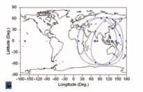
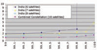
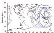
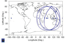
LCNSS constellations over IndiaConstellations with 6, 7 and 8 satellites have been optimized over India, trying to maximize the level of navigation performances provided by each one of them.Figure 1 shows the ground tracks described by the optimized constellations and the achievable navigation performance accuracy.This constellation is composed of four geostationary satellites and two dedicated satellites in GEIO orbits. Geostationary satellites navigation payload could be integrated as a complement to the communication payload. Figure 2 shows the worst-case HDOP performances provided over India, considering no satellite failures or outages. Worst case HDOP is below 1.5 in all points in India.The next analysed case is a 7-satellites constellation with four of them in geostationary orbits and three in GEIO orbits. The associated ground tracks are shown in Figure 3.The worst case HDOP performances that are provided over India, using a masking angle of 5º, when all the 7 satellites in the constellation are successfully working are slightly better than for the previously analysed case of the 6-satellites constellation. Worst case HDOP is now below 1.4. The real advantage of using a 7-satellites constellation is that also for higher masking angles (as for emulating urban environments), or in case one the constellation satellites is not available, the navigation performances can be kept at reasonable accuracy levels. With the 7-satellites constellation, HDOP over India does never exceed 3.6 for 20º masking angle, as can be observed in Figure 4 below, and does never exceed 3.5 for 5º masking angle when considering 1 satellite failure (Figure 4).For better characterising the navigation performances of the considered constellation, Polaris can be used for computing the HDOP performances, considering realistic failure models for the constellation satellites, for any given availability level. In this case, performances have been measured for the 7-satellites constellation over India, at a 99.9% availability level (Figure 5). Finally, the case of a LCNSS constellation over India with 8 satellites has also been analysed. It is composed of five geostationary satellites, and three additional satellites in GEIO orbits. The associated ground tracks are shown in Figure 6.The worst-case HDOP performances that can be achieved over India, using a masking angle of 5º, when all the 8 satellites in the constellation are successfully working, are obviously better than in the previously analysedcases. Worst case HDOP is below 1.2 in nominal conditions. Even for higher masking angles (in this case up to 30º), or in case of 1 satellite failure, the attainable performances are quite good. HDOP for 30º masking angle does not exceed 3 for any point in India (see Figure 7 below), and worst-case HDOP performances, for a masking angle of 5º, when considering 1 satellite failure are never greater than 2 (Figure 7).HDOP performances measured for a 99.9% availability level, considering all the satellites failures modes, are excellent also. When compared with the 7-satellites constellation, the improvement in HDOP range goes from (2 – 3.25) down to (1.5 – 1.8). Performances comparison with GPS and GalileoAnalogous results, but now obtained for GNSS, have been analysed in this section for comparison purposes.Worst-case HDOP performances that can be achieved with GPS and Galileo, using a masking angle of 25º, without considering satellite failures, are greater than 10, almost all over the Earth surface. These results are significantly worse than the ones shown in Figure 7, for the 8-satellites constellation over India, for the more restrictive 30º masking angle.Performances provided by GPS and Galileo, for the 99.9% availability level have also been measured. In this case, the obtained HDOP values are comparable to those provided by the 8-satellites LCNSS constellation. Combined use of LCNSS + GNSSLCNSS design does take into account the autonomy and the independence of the provided services. Nonetheless it is obvious that GNSS (GPS and GLONASS already, and Galileo in the near future) exist, and are working, providing accurate navigation services. So it seems interesting to investigate the potential benefits of the combined use of both kinds of navigation systems.The significant improvement in the navigation performances is the first direct benefit of the combined use of a LCNSS together with a GNSS. If the 6-satellites LCNSS constellation over India was optimized for being used in combination with Galileo, for the 99.9% availability level, the resulting HDOP would not exceed 1.05 at any point in India. Besides this, there are some other not so obvious advantages that can be obtained from the combined use of a LCNSS together with a GNSS. Figure 8: Combined use of LCNSSss (18 satellites): India / Australia-New Zeeland / Japan-Korea Figure 9: Combined Constellation (18 satellites) HDOP over India, at 5º, for different availability levels In particular, benefits in OD&TS accuracy and in integrity have been observed.One of the major limitations of the current navigation systems comes from the characteristics of the navigation signals. The problem relies on the fact that navigation signals are not real measurements, but pseudo-measurements (the clock parameters have to be estimated together with the ranges). Moreover, the poor geometry between the on ground tracking stations and the satellites in a MEO constellation based GNSS, causes the orbits and clock parameters to be strongly correlated. In the end, the strong correlation between the clock and the orbit parameters is what is liming the capabilities of the OD&TS (Orbit Determination and Time Synchronization) processes. In practise, increasing the size of the tracking network in such a way that permanent coverage from a significant number of stations is ensured, helps mitigating the problem, but does not completely solve it. If receptors were located on-board the satellites, as well as they are located at the tracking stations on the Earth surface, the combined use of a GEIO/GEO constellation together with a MEO constellation would be a sensible strategy for overcoming the problems related to the relative geometry between the satellite and the tracker. Inter-satellite links generated between pairs of satellites would be extra ranges that could be used for feeding the OD&TS batch processes. Note that inter-satellite links observables are not affected by neither ionospheric nor by tropospheric effects. The improvement in the observables quality, together with the orbit and clock parameters correlation reduction, would really help overcoming the limitations observed in the current GNSS. An alternative to the use of the inter-satellite links as extra measurements for an on-ground OD&TS batch process is to use them for feeding a standard PVT process, which would allow the generation of navigation products almost in real time. These solutions could be either directly broadcasted to the users, as navigation solutions, or could be used for being compared with the solutions obtained in the usual OD&TS batch process. This comparison would be very useful from the integrity point of view, being the basic concept for an alternative integrity approach. Combined use of several LCNSSTwo (or more) LCNSS can be used together, taking mutual advantages from each other. In this section it is going to be shown that if a 6-satellite LCNSS over India is optimised for being used in combination with two other LCNSS (one of them optimised for the Australia + New Zeeland area, and another one for Japan + Korea), the level of accuracy that can be reached is even better that the one obtained with the optimized 8-satellites constellation over India.The combined constellation is composed of 18 satellites: 3 geostationary satellites and 3 satellites in GEIO orbits, for each one of the three considered sub-constellations. The associated ground tracks are shown in the figure 8. Figure 10: Ground track evolution (after 9 months without corrective manoeuvres) Figure 11: Ground track evolution (after 9 months without corrective manoeuvres) The constellation optimisation process has been performed trying to simultaneously keep all the constellations performances at reasonable levels. For comparison purposes, the HDOP performances have been measured, for several availability levels, ranging from 99% up to 99.99%, for the different constellations and combinations of constellations presented in the previous sections. A curve representing the degradation of the performances for each one of the considered constellations, as a function of the availability level has been plotted, in such a way that the navigation performances of all the considered constellations can be easily compared. The obtained results are shown in Figure 9. Stability & feasiblity considerationsNavigation performances are driven by the geometry between the user and the navigation satellites. The constellations described in this article up to the present section are all “theoretical” constellations, which once in orbit, would be affected by the following forces: • Earth gravitational field, including tidal perturbations • Solar, lunar and other major planets perturbations • Solar radiation pressure, albedo and infrared radiation • Drag perturbations (only for very high eccentric orbits)These perturbations degrade the geometrical conditions and consequently the positioning performances too.Let’s take for example the previously mentioned combined constellation (18 satellites) composed of three sub-LCNSS. The constellation “nominal” ground track is depicted in Figure 8. If no maintenance manoeuvres were performed, the satellites orbits would be affected by the perturbations listed above, and after a certain time period, the original configuration would be degraded. This can be easily appreciated by observing the evolution of the satellites ground tracks in the figure 10. The degradation in the constellation ground tracks evolution demonstrates the need of performing maintenance manoeuvres in order to keep the navigation positioning performances at acceptable levels.The optimization process consists of slightly modifying the semi major axis for each individual GEIO orbit in such a way that the fulfilment of the optimization criteria is maximised. The inclination parameter has been set from the very beginning of this analysis as the optimum value (63.4º), which prevents the argument of the perigee from drifting. The plot below shows the evolution of the satellites ground tracks, for the optimised constellation (Figure 11).It can be observed now that the geometrical configuration after 9 months has not significantly degraded. Conclusions● It is possible to provide high navigation performances over selected regions, with a reduced number of satellites and a limited ground segment deployment. ●LCNSS are viable using constellations of satellites in GEIO orbits plus geostationary satellites. ● U sed alone or in combination with other navigation systems, LCNSS with 6 to 8 satellites have demonstrated to provide highly accurate navigation performances over the target area (India, in this case). ●Navigation performances reachable by a LCNSS combined constellation are comparable or even better to the ones provided by a GNSS. ●LCNSS are a feasible alternative to the costly GNSS. ●LCNSS can be designed taking into account stability criteria, to minimise the maintenance operations. |
||||||||||||||||||||
|
||||||||||||||||||||
|
Pages: 1 2


 (1 votes, average: 3.00 out of 5)


Leave your response!