|
|
|
|
|
 |
|
|
Products
NovAtel Inc launches new OEMV products
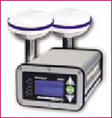
NovAtel has launched its new OEMV-1G and FlexPak(TM)-V1G products with GPS+GLONASS positioning solutions. Also, full GPS+GLONASS AdVance RTK (Real Time Kinematic) positioning capabilities are available on all existing OEMV-2 and OEMV- 3 products via its 3.2 Firmware release. www.novatel.com. |
|
|
Crescent VS100 Series GPS Compass
Hemisphere GPS has introduced the new Crescent VS100 and VS110. Based on Crescent Technology, it presents an affordable and robust heading and positioning solution for machine control and marine navigation applications including dredging and hydrographic surveying. VS100 Series is a low cost GPS Compass and delivers the performance necessary to replace traditional gyrocompasses www.hemispheregps.com |
|
|
|
Trimble launches GPS content layer for Google Earth
Trimble has launched the first multimedia layer of GPS-based adventure details for Google Earth. It has interactive information from the Outdoors catalog of GPS-on-cellular applications, also premium content from contributors to backpacker, Bicycling and Mountain Bike magazines. Users can access a wide variety of multimedia data on fitness and outdoor adventures, like routes, points of interest, pictures, A/V etc. www.trimble.com |
|
|
Raytheon gets $32.5M Excalibur contract
The US Army awarded a USD 32.5 million contract to a unit of Raytheon Co. for a system that uses satellites to guide precision artillery. The Missile Systems will perform work on the Excalibur, a GPS artillery system. Work will be performed in various US locations through June 31, 2009. www.businessweek.com |
|
|
Fugro acquires EarthData, USA
Fugro has signed an agreement to acquire 100% of EarthData group, USA. EarthData provides airborne mapping, remote sensing and geographic information services. It provides international data acquisition services and has a data processing center in China. EarthData/Horizons has a fleet of 12 aircraft and a variety of sensors which include state-of-the-art digital cameras, laser mapping systems and airborne radar mapping technology – GeoSAR. www.fugro.com |
|
|
Core Production Database Version 2.5 Now Available
CARIS has released Core Production Database (CPD) version 2.5. Using Oracle data processing, CPD is a seamless, geospatial database that enables stakeholders to consolidate their data into a single source. www.caris.com. |
|
|
Blue Marble joins ESRI Business Partner Program
Blue Marble Geographics announced joining ESRI as Business Partner Program. BMG will develop applications to enhance and expand the geodetic conversion tools of ArcGIS and other ESRI products and resell ArcWeb Services. It will also provide geodetic consulting and training services for ESRI users www.bluemarblegeo.com. |
|
|
NAVTEQ taps Autodesk to collaborate on online venture
NAVTEQ has announced Autodesk, Inc. to bring an additional array of tools and technical support to the developer community through its Network for Developers site. It aims to help accelerate the successful creation of superior location-based content for wireless and internet channels. www.navteq.com |
|
|
Magellan launches Maestro 3000 series
Magellan announced the worldwide introduction of the Maestro 3100 and Maestro 3140 portable vehicle navigation devices. It has a 3.5 inch QVGA display and a sleek design. It guides drivers with turn-by-turn voice and visual prompts. www.magellangps.com |
|
|
Combined GPS/Galileo simulation system
 Spirent Communications, UK, announces the availability of its GSS7900 GPS/Galileo Simulation System which allows the testing of advanced multi-system GNSS receivers. It simulates the RF environment to characterise, optimise and validate these receivers under accurate, controlled and repeatable conditions in the laboratory. www.spirentcom.com Spirent Communications, UK, announces the availability of its GSS7900 GPS/Galileo Simulation System which allows the testing of advanced multi-system GNSS receivers. It simulates the RF environment to characterise, optimise and validate these receivers under accurate, controlled and repeatable conditions in the laboratory. www.spirentcom.com
|
|
|
TomTom launches TomTom ONE XL
TomTom has launched ONE XL range. The 4.3 inch screen guarantees drivers a clear view of the screen. It has also launched RIDER, which is a navigation solution designed for bikers by bikers. www.tomtom.com |
|
|
Leica FCMS Flight & Sensor Control Management System
Airborne mission planning and survey flights are the first steps in powering geospatial imaging. Leica FPES is a powerful office tool for flight planning and evaluation. Leica FCMS performs all tasks, such as flight guidance, sensor release and sensor monitoring, on a single interface. www.leica-geosystems.com |
|
|
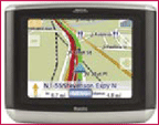
LG LN700 navigation system
LG is offering LN700, a travel solution for car users who don’t already have built-in GPS navigation system. It is first-sized and can be installed in any vehicle easily as it comes with mounting equipment.www.itp.net |
|
|
u-blox selects Spirent for GNSS development equipment
Spirent Communications would supply GSS6100 single channel production test systems to u-blox that will be used in RF development and production testing. It will also be used by field application engineers to enhance customer support. www.u-blox.com |
|
|
u-blox announces LEA-4R dead reckoning GPS module
u-blox AG has announced the LEA- 4R GPS module with built-in dead reckoning technology that will ensure 100% road coverage. It shall provide an accurate position in any environment where there are obstructed GPS signals. www.u-blox.com. |
|
|
TruePosition to provide E-911 phase II location solution
TruePosition, Inc., USA shall provide its wireless location system to Plateau Wireless. It will enables wireless carrier to satisfy the Phase II requirements of the Federal Communication Commission’s Enhanced-911 mandate. www.trueposition.com |
|
|
New GNSS Receiver Option for Applanix POS AV
Applanix has introduced a new GNSS receiver option for its airborne vehicle, POS AV supporting GPS and GLONASS signals. Raw data can now be logged from the receiver along with IMU data for GNSS-Aided Inertial post processing through the POSPac V4.4 software. www.applanix.com |
|
|
PCI Geomatics supports University of Regina project
PCI Geomatics announced its support for the Canada Foundation for Innovation (CFI) which funds research infrastructure helping Canadian universities and colleges carry out technology development. It has provided assistance to the University of Regina recently. www.pcigeomatics.com
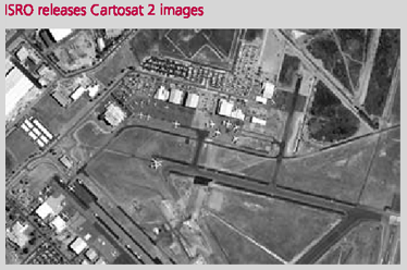
Perth Airport, Australia as seen by CARTOSAT – 2 (www.isro.gov.in) |
|
|
BAE systems to continue hightech mapping for pennsylvania
BAE Systems shall be carrying out next phase of digital mapping of the Commonwealth of Pennsylvania, USA. A $2.7 million contract, it will continue the development of base map data supporting the statewide geographic information architecture called the Pennsylvania Map (PAMAP). www.baesystems.com |
|
|
Switzerland upgrades its nationwide positioning network
Trimble has announced supply of 31 NetR5 GNSS reference stations and Zephyr Geodetic 2 antennas to Switzerlands Federal Office for Topography (swisstopo) to upgrade its nationwide positioning network. The infrastructure will support signals from GPS and GLONASS. www.trimble.com |
|
|
Bentley BE Excellence Award to AAMHatch
The BE Excellence Award was presented to AAMHatch Director, Peter Blake, in Los Angeles on 1 May 2007. The project that achieved this global recognition was the True Orthophoto of Melbourne City. “We are excited to have won this award as it highlights our technical leadership in 3D Mapping. This project also recently won an Asia Pacific Spatial Excellence Award,”said Mr Nicholls, General Manager of AAMHatch.www.aamhatch.com.au |
|
|
New version of FleetOutlook fleet management application
Wireless Matrix Corporation, USA announced the release of latest version of FleetOutlook. It is hosted by Wireless Matrix and delivered as “software as a service”. It combines vehicle communications, GPS location and mapping capability, and vehicle monitoring and reporting www.wirelessmatrixcorp.com |
|
|
GPS mapping Free on your mobile
MGMaps combines Google Maps, Yahoo Maps, Windows Live Local and Ask. com maps to generate more relevant results for free. Independent developer, Cristian Streng released its latest update fixing various bugs and introducing the support for GPS tracking. It works using a phone’s built-in or additional GPS receiver (connected via Bluetooth) by downloading satellite images to the handset via 3G, charged at standard datapacket download rate. www.tech.co.uk |
|
|
Lockheed Martin completes GPS III system design review
Lockheed Martin has completed onschedule a system design review of the U.S. Air Force’s next generation GPS Space Segment program – GPS Block III. www.lockheedmartin.com |
|


 (No Ratings Yet)


