Policy


India’s National Map Policy Guidelines: A new move(ment)

Jun 2006 | Comments Off on India’s National Map Policy Guidelines: A new move(ment)

India comes out with guidelines for implementing its National Map Policy that was announced last year. We present guidelines and observations by Professor George Cho and Professor JG Krishnayya. We will continue this discussion in the next issue

1. Background

The Central Government announced the National Map Policy (NMP) on 19th May 2005. The NMP document authorizes Survey of India (SOI) to issue detailed guidelines on the implementation of the NMP. These guidelines are issued in the light of the above cited authorization. The guidelines are clarificatory in nature and does not create any new rights nor abridge any existing rights which are enforceable in courts of law.

2. Information on Maps and guidance of indentors

a) All up-to-date information on SOI maps shall be available at the various offices, map sales counters and Geospatial Data Centres (GDC)

under the SOI. The information shall also be available on Survey of India website www.surveyofindia. gov.in created and maintained by the SOI. The information provided inter alia includes all relevant details of maps such as scale, information content, date of data capture, price, mode of data dissemination whether MOD clearance available for issue as Open Series Map (OSM) etc. The website also has a search engine by which the exact sheet number of a given locality can be traced by giving elementary details like name of district or any other prominent feature. SOI offices may be contacted for further information on OSMs.

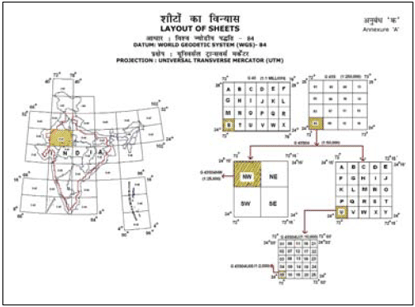
b) The lay out of OSM sheets on UTM projection and WGS 84 datum is shown in Annexure ‘A’. The annexure also shows the incidence of the existing topographical series on the OSM series.

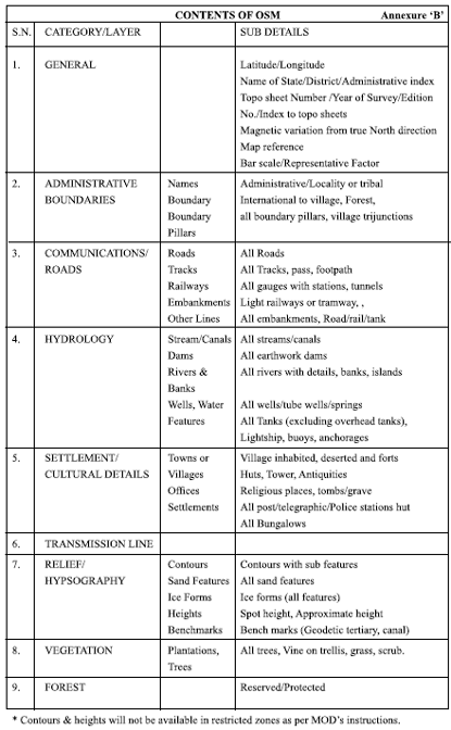
c) Data content: Approved data content of OSMs is given in Annexure ‘B’.

d) Export of all maps/digital data in 1: 250K and larger scales through any means is prohibited vide Ministry of Finance (Department of Revenue) Notification No. 118-Cus./F.No.21/ 5/62-Cus. I/VIII dt. 4th May 1963. Digital Topograhical data will be licensed to only Indian individuals, organisations, firms or companies.

3. Sales/ Data Dissemination:

(a) Analogue/Paper Maps: of all scales shall be made available from Survey of India (SOI) offices and Map Sales Counters on payment at prices as may be fixed by SOI from time to time. The list of such outlets, their addresses with telephone numbers shall be made available in the website www.surveyofindia. gov.in. These maps can also be sold by any retailer. Digitisation of SOI analogue/paper maps is strictly forbidden.

(b) Map Transaction Registry (MTR): As stipulated in the National Map Policy, Survey of India will establish an online MTR for recording of all transactions relating to digital maps. Each user will be allotted a unique user ID and each transaction with a unique transaction ID. For all future correspondence, this user ID and Transaction ID should be referred.

(c) Digital Maps: include both Raster and Vector forms. The ownership of all digital data vests solely with SOI and will be given only under licence against indent and on payment. Unauthorised copying and distribution of SOI digital data are strictly prohibited. All licenses will be issued through the Map Transaction Registry (MTR). The format of the licences is available in SOI web site www.surveyofindia.gov.in. The indents may be made in the prescribed proforma (appended as form A).

image-may-2006-12

4. Licensing of Digital Maps:

Digital data will be available in single/ multiple/ commercial licensing for general use, value addition and marketing. All digital maps will be provided with encryptions/mechanisms which may corrupt the data while copying unauthorisedly or while attempting the same. Every such attempt shall attract criminal and civil liability from the user without prejudice to the corruption of data or software/hardware for which the SOI will not be liable. SOI digital data will be licensed based on usage. Following are the categories:

Digital Licence

Publishing Licence

Internet Licence

Media Licence

Value addition Licence

Terms and conditions governing each of the licence is available in SOI web site www.surveyofindia.gov.in.

5. Procedure for value added products

Inasmuch as the NMP is aimed at encouraging a flourishing geospatial industry and related knowledge services, there is much expectation from the industry to do value additions to the products of SOI. SOI encourages individuals/ industry to do value addition. Intending value adders will submit a business model indicating the products to be generated and marketing strategy and also execute a Memorandum of Agreement (MOA) with SOI.

6. Pricing of various products:

(i) The SOI shall notify from time totime the price list of its standard products.

(ii) The prices are subject to revision from time to time.

(iii) An indentor has to pay the amount at the rate prevailing on the date

of supply unless the indenter has already paid at the earlier rates. In other words, the indenter will not be eligible for supply on payment on the plea that the rates prevailing on the date of indent were lower.

(iv) The SOI reserves its right for differential pricing, such as concessions to Universities, Research organizations, deserving NGO’s on the basis of predetermined policies, different prices between single and multiple user licenses etc.

7 e- Payment:

Digital maps, on following the procedure, will be made available on variety of media like Compact Disks (CDs), DVD etc. Maps on 1:1M and smaller scale on compressed JPEG format will be available for download against online submission of licence agreement and on epayment. The self-guide provided in www.surveyofindia.gov.in shall enable an indentor to make e-payment and download the requisite maps.

image-may-2006-13

8. Settlement of Disputes:

In case any dispute arises on the applicability or interpretation of these guidelines between the SOI and any other person, the matter shall be referred to the Secretary, Department of Science & Technology, Government of India, whose decision shall be binding on both the parties.

9. Applicability of previous instructions:

The Ministry of Defence has from time to time issued detailed guidelines on various aspects of map access and use. These instructions shall continue to hold good but for the modifications cited in the NMP.

10. General:

(i) Copyrights of all SOI maps (both digital and analogue) vest exclusively with the SOI. Any person resorting to unauthorized copying or use or attempts to do so shall make him liable to criminal and civil liability under existing laws.

(ii) While every effort will be made to ensure availability of maps of all areas containing all necessary details and with highest accuracy, SOI will not be responsible for any loss caused to any person on account of failure on any of the above factors or any other reason.

(iii) The SOI reserves the right to add, delete, modify amend any or all of these guidelines without notice and without assigning any reason.

MTR sounds to be too rigid

photo-5-june-06Prof JG Krishnayya

Director, Systems Research Institute, Pune, India

geoconcept@vsnl.com

It is good that SoI has been quick to release a comprehensive statement on the manner in which digital maps will be made available to the Indian mapping community.

I assume that these Guidelines will be modified as the real-world experience suggests where changes will improve communication, increase speed, simplify operations. This kind of openness to the possibility of change is always needed.

Committing the SoI to have available all information at all SoI offices, and on the website is a good thing.

Committing the SoI to UTM and WGS-84 – international standards – is also really a great improvement.

Data Content

Here is where one has to raise questions again about the elimination of all height information from OSM maps. We would appeal again to the SoI and the MoD that they consider the purposes for which digital maps are needed and are to be used in India.

For the foreseeable future, the most important geographic problemfacing the country is (a) Urban expansion and (b) Global Warming and related problems, including water availability. Of the two (b) is more serious, although (a) is more urgent. Particularly where we are tracking snow-melt, and snowpack, height information is very very important. As water becomes ever more a valuable resource, flow information, flow possibilities and therefore height information becomes more and more important. It is very obvious to any urban planner that height information in and around settlements is essential for rational planning. For these – and many other – reasons, we would appeal to the MoD to relax their veto of height information. The international strategic situation, the types of conflicts that India is likely to be in, also suggest that 1-5-10 meter contours will not be important for our defence at a time when satellite-derived information is freely available to potential enemies.

MTR

The concept of the Map Transaction Register which enables IT-based total control over the distribution of maps, sounds to me to be too rigid for the culture of the Indian subcontinent. India and Indians do not have the discipline in our culture to sustain such a welldefined methodology (and I say that without criticising our undisciplined, untrammelled style of living). (I note, by the way, that the Guidelines apparently make it illegal for any body, individual or corporate, who is

not “Indian” to indent for or to posses an SoI digital map.) It is not clear to me whether this is entirely realistic.

Pricing

The idea of concessional pricing for NGOs, for Educational institutions, for Research is a good idea, as is the separation of Single-copy, Value-added, Commercial, etc. “markets” – and therefore licensing regimes for maps.

However, I wonder whether everyone who would like to make amendations to SoI maps before using/reselling them in a niche market would be able to create a business plan on the basis of which an MoA could be drawn up. This would tend to restrict access to maps to larger organisations, I fear. This approach seems to be patterned on that of The Ordnance Survey (UK), where the situation is quite different from India’s, so that I feel such a practise could well be held up for a decade or so until the Indian digitilmap- market has matured more.

Glacial progress

photo48Prof George Cho

University of Canberra, Australia

george.cho@canberra. edu.au

The Guidelines are part of the National Map Policy (NMP) announced nearly a year ago (www.surveyofindia.gov. in). This policy authorises the Survey of India (SOI) to issue guidelines for the implementation of the NMP and in particular the use of SOI products – analogue and digital. This commentary makes reference to the paragraphs in the Guidelines. The Guidelines consist of four short unpaginated pages, two annexes and a Digital Products Indent Form.

Paragraph 1 provides the background to the NMP at 19th of May 2005 and the origins of the Guidelines.

In para 2(a) it is mentioned that upto- date information on SOI maps will be available everywhere SOI products are handled. A web site address is given for Internet transactions.

Export

More significantly para 2(c ) pertains to approved data content of all Open Series Maps. Further details are outlined in Annex ‘B’. However, mention is made that “export of all maps/digital data in 1:250K and larger scales through any means is prohibited”. Users might ask the question of the meaning of “export”. Any local company may export derived products, albeit, based on SOI information; would this be permissible?

Licence

The next sentence states that “topographical data will be licensed to only Indian individuals, organisations, firms or companies”. The meaning of licence is not defined. Is this a licence to use, a licence to copy, a licence to re-purpose? Further only Indian individuals may be licensed. It is unclear whether this includes those with dual citizenships, Indians but non-citizens, and Indians (presumably citizens).

Digitigation

On para 3 the heading on Sales/Data Dissemination contains three subsections. In particular sub-para (a) prohibits the “digitisation of SOI analogue/paper maps”. The Guidelines do not state whether these are in raster or vector form and is silent about whether scanning the whole map sheet as one image is permissible.

MTR

Para 3(b) refers to a map transaction registry (MTR) presumably a record of all sales and licensing transactions undertaken. Users will gain a user ID and a transaction ID – presumably for future use and tracing.

Copying

Para 3 (c) states that digital maps include both raster and vector forms. The claim to ownership by SOI is made here on all digital data and will only be given under licence against indent and payment. This appears reasonable. But then the Guidelines goes on to state that “unauthorised copying and distribution of SOI digital data are strictly prohibited”. It is unclear what this copying means because once an agency is licensed by SOI it should be able to make copies within limits of the license. How, for instance, could a company operate if it cannot copy its data for its subsidiary or branches. This statement also begs the question as to whether authorised copying is permissible. Everything seemingly will hinge on the words and terms of the licence that has been provided by SOI.

Formats of licence

In this paragraph the Guidelines discuss the format of the licences and

point to its availability on the SOI website. The SOI website provides four main types of licences – media, publishing, digital and Internet. Each of these are pdf documents and are quite comprehensive. Among others, the licences in general deal with the scope and terms of the licence agreements (in terms of definition, licence, licensee’s obligations); SOI liabilities, Intellectual Property Rights (IPR), Annual licence fee, Changes to the licence, Audit and inspection rights, Transferring rights and responsibilities, Arbitration, Relationships, Force majeure, Termination, Non-Waiver, Governing law and Jurisdiction.

Licensing of Digital Maps

Para 4 deals with Licensing of Digital Maps. While the licensing of the digital data provide for general use, value adding and marketing, there is a statement which warns that encryption technology has been incorporated into the digital products. The original data will be destroyed if the data were subject to copying activities. Criminal and civil liability attach to these unauthorised activities. The issue here is therefore how any company can make use of the data in order to value add to it or use it for marketing purposes without being given the decryption key to unlock the data. This makes the task of re-use, repurposing the digital data extremely cumbersome and difficult – which presumably is the object of the policy. No details are given as to which parts of the criminal code or civil law would swing into play once someone is detected infringing the agreement.

The format for the “value addition” [sic] licence is not given on the SOI website.

In presentation terms it is believed that it may be better placed to have the various licenses given here as annexes rather than having users refer to the SOI website. Doing so would ease the task of adopting its use more readily.

Value added products

Para 5 deals with Procedure for Value added products. This paragraph contains a good suggestion in the sense of attempting to encourage the geospatial industry and related knowledge services (as well as the location based service industries). The requirement that a business case be mounted under a memorandum of understanding is something new. This innovative requirement should be applauded and should be welcomed by companies using SOI. The key to success in growing the geospatial industry is one of a partnership rather than a structured hierarchical one of giver and taker.

Pricing

Para 6 spells out the pricing scheme of various products while para 7 gives details on e-Payments. Again this is a good initiative but could be open to abuse in several ways, for instance, non-citizens hiding behind nom-de-guerre in credit cards issued by Indian financial institutions.

Settlement of disputes

Para 8 is about the settlement of disputes while para 9 is about the applicability of previous instructions. The final para 10 is about “copyrights of all SOI maps”. In reality, this should refer to the more generic intellectual property right. There appears to be a gender bias where a statement begins with “any person” and concludes with “shall make him liable to” criminal and civil liability. Whilst there is a disclaimer in sub-para (ii) (which strictly to be pedantic should be alphabetized rather than numbered) it does not state to what accuracy standards the details are compared with and whether such a disclaimer on possible loss is sufficiently watertight against possible litigation.

Annex A gives the layout of the sheets under the SOI system of mapping. Annex B gives the contents of the open series maps. These look like the beginnings of metadata headers for digital files of geospatial information. But on closer inspection, the content are of insufficient detail for more universal use or for international comparability.

Data content

Form A is the SOI Digital Products Indent Form – a 3-paged form for use if one wishes to purchase or get a licence for SOI products. However, such a form lacks a warning on possible civil and criminal liability for entering false information and there is no disclaimer here about the accuracy of maps supplied and the limitation of liability from action for loss or damage incurred as a result of its use.

Overall, an interesting development but reflects the glacial progress into the digital age of a heavy bureaucracy as well as the reality of the information technology revolution in changing the nature of maps in general. however, these Guidelines compare well with the more generic ones in use by Geosciences Australia and Australian government policies Geosciences Australia Digital data licensing and sales policy at

http://www.ga.gov.au/ nmd/products/purchasing/licencing.

htm; and Australian government spatial data policies and guidelines at

http:// www.osdm.gov.au/osdm/policy.html).

My coordinates
EDITORIAL
His Coordinates
Steve Berglund
News
INDUSTRYLBS | GPSGIS | GALILEO UPDATE
Mark your calendar
May 09 TO DECEMBER 2009

1 Star2 Stars3 Stars4 Stars5 Stars (No Ratings Yet)
Loading...