| His Coordinates | |
“GNSS industry and the associated applications will be relatively less impacted by Covid-19”
 |
|
With the world turning upside down, do you think this is time for the organisations to redefine their vision and missions in line with the changing paradigm?
Covid-19 has impacted practically every organisation and citizen across the globe. First I would like to say that my thoughts are with those who have been most heavily impacted, whether it be from a health or economic perspective.
In an organisation, when a risk is realised, as has been the case with the pandemic, it’s always an opportunity to reflect and learn from what has happened and how the organisation responded. For some it will be a review, for others a major change, whether as an individual or an organisation.
How has Covid-19 impacted RIN activities? How you plan to deal with it?
The Royal Institute of Navigation’s aim is to promote knowledge understanding to advance positioning, navigation and timing in all its forms. To an extent this can still happen virtually – one really unexpected thing for us has been that far more people have joined presentations and training we have offered online than we would ever have seen at a physical meeting. The challenge is that during a talk or presentation gets everyone only starts to think through the topic; the really great discussions, insights and ideas normally flow when you meet afterwards. As soon as it is safe to do so we will plan to start meeting together in person again. However, it seems certain that most meetings in future will also include a hybrid element, with an opportunity to join online too.
What likely impacts you anticipate due the ongoing Covid-19 crisis on GNSS industry, especially in the context of economic impact in UK and in EU?
The only certainty at present is uncertainty, probably for some time to come. The tragedy of the present pandemic seems to be that the highest impact is on the weakest. While this is painful to witness, I believe it’s true to say that the GNSS industry and the associated applications are, generally, relatively strong and hence will be relatively less impacted. Those skilled in positioning, navigation and timing will still be in demand in a high-tech world that will continue to value science and data literacy.
What challenges you see before the academic community and GNSS education? How do see the fallout of this crisis in job creation and employment?
The short-term challenge is that mobility is restricted. The UK attracts many international students and these will be lower next year, resulting in a projected 25% average reduction in income for universities. This, in turn, is leading to structural and operational reviews.
However, I am a great believer in what I call the “fundamentals”. It is a fact that science, technology, engineering and maths are needed to enable global sustainable development. Also that resilient position and time are essential everywhere in the modern world. As such, I believe that job creation and employment related to positioning, navigation and timing will continue to grow, as the fundamentals needs and opportunities are strong.
Do you see some new opportunities emerging out of this?
We have seen in many places that technology presents opportunities but is not always intelligently or optimally applied to solving problems. Contact tracing apps based on smartphone proximity sensors is a great example. So, generically, I see a real need and opportunity for more “systems thinking” to solve big problems. Applying the rigour and discipline of systems integration is a real opportunity to increase both impact and productivity.
In August 2010 in an interview with Coordinates you predicted that “Eventually all receivers will be multi-GNSS.” How do you see now that observation?
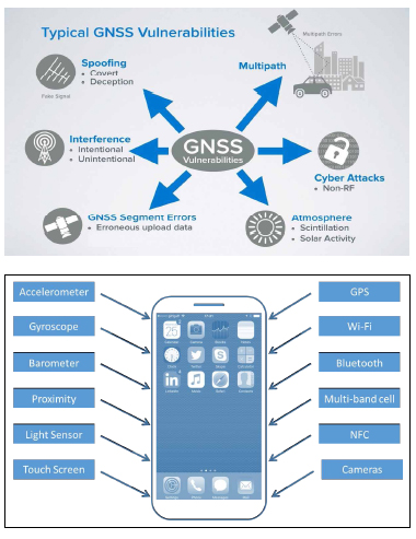
Well, it’s usually a really bad idea to predict the future, but that one has been proven right! My next prediction? Eventually all positioning, navigation or timing systems will integrate multiple sensors and not rely on GNSS alone. This is necessary to achieve resilience in the face of growing cyber threats as the world becomes more connected.

With increasing dependence on GNSS, how do you the perceive the threats like interference, jamming and spoofing?
Each is increasing and becoming more sophisticated, but generally in a predictable way. To combat this, we will see more layered systems approaches to deliver trusted position or time. There will be no one solution, but by assessing requirements and risks methodically it is possible to build resilient and robust positioning systems, even with increased interference, jamming and spoofing.
How do you think the GNSS positioning technology can take the advantages of alternative positioning technologies cell phones, Bluetooth and WiFi, etc.?
Sensor fusion in mobile devices already combines these technologies to offer almost continuous positioning – there is always a “blue dot”. However, the issues at present are that accuracy for Wi-Fi and cellular positioning are relatively lower than GNSS. Current developments to measure round-trip-time rather than received signal power will bring us a real improvement in accuracy for Wi-Fi and cellular positioning. Another really interesting development for positioning is the increased use of cameras in phones, and possibly also other sensors such as ultrasound as a type or radar.

Would you like to comment on autonomous navigation?
This is a big topic. My top level observation is that I see great potential for fully autonomous systems to be much safer and more efficient than current so-called driver assistance or semi-autonomous modes.
After Brexit, would you like to comment on its implication on Galileo? What about an UK GNSS?
For most applications the open services are all that is needed and there are already plenty of ranging sources available from the existing GNSS’s. My understanding is that the UK’s current use of encrypted GPS for military purposes is not impacted by Brexit. So in many ways there is not a “problem to solve” in relation to provision of services. The question of whether the UK needs control over its own space-based positioning, navigation or timing assets is very much a strategic and political question that I am happy to leave to the politicians to decide!


 (5 votes, average: 4.20 out of 5)


Leave your response!