
| Surveying | |
Educating primary school students about surveying
This paper presents an innovative initiative to engage primary school students (and their parents) with surveying in a way that is both educational and fun, while also delivering real-world benefits to the surveying profession. |
 |
|
Surveying is a unique and rewarding career that enables exposure to cutting-edge technology, involves conducting detective work in the field and significantly contributes to society. While surveying offers great job prospects with the opportunity to specialise in numerous areas, it is plagued by a notorious skills shortage and continuing problems to attract enough tertiary students to feed demand. The ageing demographic of the existing workforce and a lack of diversity within the profession only exacerbate these woes (Underwood and Powell, 2019; Cripps and Fairlie, 2024).
While the surveying profession has a long history of evolving and adapting to inevitable change driven by political, economic and technological factors (e.g. Enemark, 2009; Staiger, 2023), sometimes there is stubborn refusal to acknowledge that change is both inevitable and continuous. To stay relevant in an era of non-skilled users increasingly capturing geospatial data, the profession must identify innovative ways to add value to measurement and geospatial data and then promote this value within society to raise the public profile of the surveyor (Underwood and Powell, 2019).
Promotion of the profession to school aged students provides surveying exposure to a wide audience and helps develop a pipeline of future surveyors. Over the years, many initiatives have tried to attract young people into surveying. For example, in Australia, the Surveying Taskforce was created to help combat the current shortfall of surveyors. It set up a website to capture those considering a career in surveying, has a social media presence and provides resources for presentations to school aged students (Surveying Taskforce, 2020). Surveyors can become a ‘surveying ambassador’, which provides opportunities to be involved in career events, school presentations, assisting with information days or hosting work experience students.
The ‘Get Kids into Survey’ campaign, developed in the UK, offers resources such as surveying-themed colouring sheets, activity posters, homework projects and the Geo Squad comic (Ball, 2025). Again, engagement of the profession is sought via ambassadors and sponsors to utilise the available resources and reach the target audience.
Similarly, the UK Ordnance Survey (OS) gives away free maps to 11-yearolds through their schools (Owen, 2007). Each year 7 pupil in England, Scotland and Wales receives a free 1:25,000 scale OS Explorer map of their local area, resulting in more than 700,000 maps being distributed through schools every year. It now produces special paper and wall maps centred on the schools, helping children to learn geography in their own backyard and that all-important sense of direction.
At the university level, efforts have been undertaken to modernise the curriculum and increase student intake in various ways (e.g. Enemark, 2009; Roberts, 2016; Roberts and Harvey, 2019). Furthermore, the use of humour can improve student learning and help convey scientific information to a much wider and more general audience (e.g. Janssen, 2012, 2019, 2023; McAlister and Hill, 2023). While many of these initiatives have been successful, unfortunately the problem persists with the capability gap in Australia reaching 1,500 surveying professionals in 2023/24 as new supply from graduates falls short of the increased demand (Consulting Surveyors National, 2023).
Consequently, the education of the public and the continued promotion of the surveying profession is the responsibility of all surveyors. This paper presents an innovative initiative to engage primary school students (and their parents) with surveying in a way that is educational, healthy and fun, while also delivering real-world benefits to the surveying profession in New South Wales (NSW), Australia.
Background
DCS Spatial Services, a unit of the NSW Department of Customer Service (DCS), is responsible for the maintenance and improvement of the NSW survey control network, made available to users via the Survey Control Information Management System (SCIMS). SCIMS is the state’s database containing more than 250,000 survey marks on public record, including coordinates, heights, accuracy classifications and other metadata.
When the COVID-19 pandemic was raging in 2020/21, people around the world had to juggle working from home, childcare, child education and entertainment, all while observing the lockdown restrictions in force to combat the coronavirus outbreak. During these challenging times, the author introduced his then 8-year-old daughter to a new game: ‘SSM spotting’. This was explained as combining a treasure hunt with the ‘Spotto’ game (spot a yellow car on the road and the first person to call out ‘Spotto’ claims the point). It included walking around the neighbourhood (exercise and mental health benefits, while practising a sense of direction) and looking for survey marks along the way (entertainment). This could also be thought of as a very specific form of geocaching. We found many interesting types of survey marks (education): nails, drill hole and wings, survey pegs, Permanent Mark (PM) cover boxes (often with dots of yellow paint on power poles or fence posts providing clues to their location) and, of course, many State Survey Marks (SSMs) located along the kerb. We intentionally avoided those survey marks (PMs) that were placed in cover boxes (cast steel box with liftable lid) to avoid digging and any ants or spiders hiding under the lid.
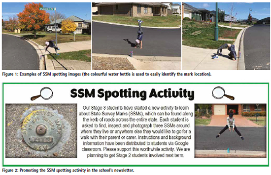
The author took photos of all the SSMs we came across, often with his daughter performing handstands, bridges or the splits while pointing to the mark (exercise and entertainment) (Figure 1). In total, 70 SSMs were photographed, and the images added to the DCS Spatial Services archive. Later, SCIMS was updated with metadata related to these survey marks to improve the information held on public record (innovation and customer service). Note the use of a bucket hat to provide sun protection and to help make the photographed subject more anonymous.
Primary school activity
Bathurst South Public School is a primary school educating about 220 students from kindergarten through to year 6. In late 2021, the author approached the school’s principal with a proposal to introduce SSM spotting as an activity that not only ticks the boxes of education, exercise and mental health, but also promotes community engagement. The aim was to engage students (and their parents or carers) with surveying and encourage them to view their surroundings a little differently (most people are oblivious to survey marks), while producing rewarding outcomes that are used by the NSW Government and the surveying profession in the real world.
The proposal was met with considerable support and enthusiasm, and it was decided to trial the activity in a single year 5/6 class in 2022. After completing the mandatory Working with Children Check, the author gave a presentation to introduce the activity, followed by a practical demonstration at two survey marks in front of the school. Soon after, a class excursion was organised where students would take turns in finding, checking and photographing survey marks while walking along residential streets surrounding the school. The excursion was well received by the students who were eager to participate in this peculiar treasure hunt.
During this time, relevant documentation and processes were refined based on the experience gained and any feedback received. This included considering the following concerns:
• Road safety: Students and their parents/carers will be used to walking on the footpaths along their local roads together, so this should not be an issue. If their residence is along a busy road, they should select a quieter area for this activity.
• Wheelchair access: Footpaths suitable for wheelchairs are available in various parts of town, providing safe access to survey marks.
• Children in photos: Parents/carers need to be made aware that the photos taken of the survey marks will be included in the NSW Government’s archive of survey mark photos. Having their children shown in the photos is optional and not necessarily encouraged.
• Privacy: The names of participating students are not disclosed to DCS Spatial Services. Any file or folder names including personal information are anonymised before being passed on.
• Work Health and Safety (WHS): The activity was assessed and conducted under the school’s WHS policies and insurances.
Due to the packed curriculum and other school activities taking priority, it took another year until SSM spotting was rolled out across all stage 3 (year 5 & 6) classes in 2023. Again, this was accompanied by a presentation and practical demonstration. The activity was also promoted in two issues of the weekly newsletter distributed to students and their families (Figure 2).
Instructions for students
Background information and instructions provided in written form and during the presentation and demonstration sessions purposely used language appropriate to the target audience. It was explained that surveyors are experts at knowing their location or position. They measure angles, distances, height differences and positions to determine where things are and how they relate to each other. Students were introduced to different types of survey marks (and their purpose) and informed that the data collected will be used by the NSW Government for the benefit of the community.
In summary, the instructions included:
• Take a parent/carer for a walk in the neighbourhood and find at least three SSMs located along the kerb of the road.
• Inspect the survey mark, brush off dust if required, and write its number and health status (stable, unstable or damaged) on a notepad.
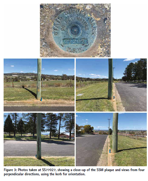
• Take up to five photos in landscape format, including a close-up of the mark itself showing its number plate and (if possible and safe to do so) a photo from each of four perpendicular directions showing the mark and any background.
• Move clockwise around the mark when taking photos and place a colourful water bottle next to the mark, so it can easily be identified in the photos (Figure 3).
• Take a photo of the simple list showing the marks spotted and their health status.
• Download the photos and rename them, so we can easily see which photo belongs to which survey mark and when it was taken (e.g. SS123456_20230413_1. jpg and SSM_health.jpg).
• Organise the files into folders and upload them to the school.
• How to use the free NSW Survey Marks smartphone app to explore survey marks further or get some clues about where to find them.
• How to use the sketch plan like a treasure map to find the survey mark.
• What to bring and how to be safe.
The uploaded files were checked (and anonymised if required) by the school and passed on to the author at DCS Spatial Services. Data management then included ensuring correct file naming, selecting the preferred set of photographs for marks spotted by multiple students and assessing the health status of each mark based on the photographs and the students’ comments. A tally was kept, documenting the spotted marks and including relevant metadata required for the integration of this information into DCS Spatial Services databases and archives.
Results
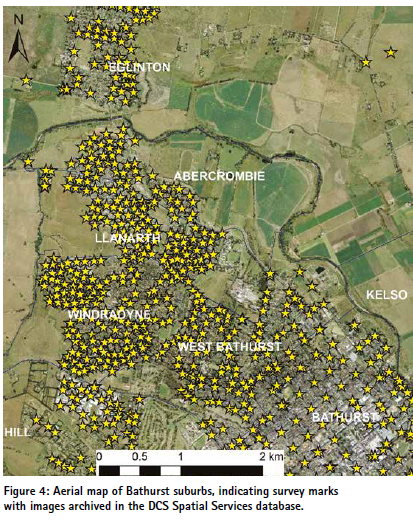
The SSM spotting activity at Bathurst South Public School resulted in 275 survey marks (including 25 PMs) being spotted, photographed and then updated in SCIMS. The photos have been added to the DCS Spatial Services archive, significantly increasing the number of survey marks with available images in Bathurst (Figure 4). In the future, these photos may be made available to surveyors via a modernised SCIMS to assist them in survey planning, e.g. in determining whether a particular survey mark is affected by tree cover or other obstructions (negatively affecting satellite-based positioning) or whether an instrument can be set up on the mark safely and with minimal disruption to traffic. To this end, blur filters may be applied to protect the privacy of any persons in the photos if required.
The SCIMS metadata update included specifying the mark status (generally ‘found intact’) with a corresponding comment and date, along with specifying (or confirming) the mark type and entering (or confirming) information about who placed the mark and when it was placed by interrogating the locality sketch plan on public record (Janssen, 2025). For PMs, the height of the mark below/above ground level was also measured and archived (for SSMs this value was generally zero).
Some survey marks were found damaged or in need of repair.
The students’ notes on the health status of each mark in conjunction with the close-up photos taken were crucial in ascertaining whether repair work was required. For example, DCS Spatial Services performed repairs in cases where the SSM brass plaque was wobbling in the concrete, removable from the kerb, buried by recently added bitumen or where part of the mark number had been rubbed out. Some PMs were also repaired to allow easy opening and closing of the cover box, and to remove trip hazards caused by stuck or missing lids. On one occasion, a cover box that had been pushed off the mark and thereby prevented the survey mark from being occupied was recentred, enabling it to return to service.
Challenges
While these results are very pleasing and encouraging, several challenges were encountered. Despite the considerable support and enthusiasm shown by the school, it proved difficult to include the SSM spotting activity in an already packed curriculum. This caused the activity to be drawn out over two school years, which may have negatively affected the interest and enthusiasm shown by the students involved in the initial pilot. Like homework, the activity was not compulsory (or not promoted as such). Unfortunately, it was not possible to include SSM spotting as an option in the suggested homework roster distributed to students for the school term. For this cohort, the activity relied on parental supervision, and parents/carers may have been more inclined to partake or adequately prepare for the activity if it were perceived as compulsory.
While there was a lot of interest among students, particularly during the very successful class excursion, only a few students followed through with the entire activity in their own time afterwards. Several students reported spotting survey marks but not taking any photos at the time or taking some photos but not uploading them to the school. The offer to help with the downloading and renaming of images in the school’s computer lab was not taken up. Consequently, most marks were completed by only a few students, mainly by the author’s daughter (who, understandably, became less enthusiastic as time went on). Asking a few school friends to come along increased the fun factor and extended the duration of participating in the activity. Towards the end, the author embarked on a couple of solo trips to capture the remaining survey marks in a particular area.
The SSM spotting activity attracted the attention of concerned residents on social media. A local neighbourhood group lit up with posts pertaining to a strange person walking around the streets, apparently taking photos of his water bottle sitting on the gutter, sometimes while children are posing in the photos. While some posts were concerned about the person’s mental wellbeing, others speculated that he may have a more sinister motive and was actually taking photos of people’s houses to discover whether CCTV cameras are installed. The mystery was eventually solved through an explanatory post by one of the author’s colleagues. A few residents made the effort to say hello to the strange person walking the streets and were promptly informed of the school activity taking place.
Potential extensions and future activities
SSM spotting can be adapted to students at high school, Vocational Education and Training (VET) institutions (such as TAFE in Australia) and university. High school students may be more suited than primary school students as they are more independent and potentially more interested in following through depending on possible job interests.
As a potential extra relating to spatial awareness, students could be asked to draw or produce a treasure or mud map of the roads searched for survey marks, indicating where each SSM was found with a symbol, labelling them accordingly and including a north arrow. For older kids, the activity could be modified by first checking SCIMS (via the NSW Survey Marks app) for suitable survey marks to track down, similar to geocaching. In urban areas, it could be expanded to include PMs in the footpath, provided the appropriate tools are carried and WHS measures are in place (e.g. including a large screwdriver to open the cover box, a glove for protection from animals and to scoop out dirt, and a measuring tape to determine the mark-to-ground-level height).
From high-school age onwards, students could be asked to measure coordinates with a smartphone or handheld Global Navigation Satellite System (GNSS) unit and create a map with an opensource Geographic Information System (GIS) package like QGIS. This progression from treasure hunt to taking simple measurements not only increases the activity’s challenge and complexity but also allows an introduction to coordinate types and systems.
Students starting a VET or university course in surveying could benefit from SSM spotting as an activity to get a better understanding of the different types of survey marks and their importance, along with exposure to the NSW Survey Marks app, SCIMS and the role of state government in maintaining the state’s survey infrastructure. Searching for, identifying and photographing survey marks and updating their metadata could be a useful hands-on practical field exercise. Students could be required to identify a variety of survey marks (cadastral and survey control), including examples of ‘found’, ‘uncertain’ and ‘destroyed’ marks, and use the app to submit updated metadata. In addition, they could load these as a layer in a GIS and be required to find marks not previously visited by other students.
The wider profession could also be involved in SSM spotting, e.g. while contributing to a worthy cause. STEPtember is a global health and wellness fundraising event supporting life-changing cerebral palsy research. It encourages participants of all fitness and ability levels to take part in more than 40 activities to complete a daily target of 10,000 steps. The author encourages the wider profession to mimic the primary school students and find as many survey marks as possible, while staying healthy and supporting a worthy cause.
The NSW Survey Marks app has the potential of being an important tool to help engage students and potentially foster citizen science if it is desired to target an even wider audience (such as the geocaching community). Via its report function, the app can be used by any person to easily upload photos and report on the health status of a survey mark. However, it should be noted that this provides a direct conduit to DCS Spatial Services rather than utilising a moderator as may be desired for a school or tertiary education project to avoid duplication.
Conclusion
This paper has introduced an innovative initiative to engage primary school students (and their parents) with surveying in a way that is educational, healthy and fun, while also delivering real-world benefits to the surveying profession. Students were asked to take their parents/carers for a walk, find SSMs located along the kerb, investigate each mark’s health status, take photographs, organise the images, and then upload the data to the school.
At Bathurst South Public School, the SSM spotting activity resulted in 275 survey marks being spotted and photographed. Associated metadata was then updated on public record, and the photos have been added to the DCS Spatial Services archive. This has helped to maintain the NSW survey control network for the benefit of the profession and the wider community. Some survey marks were reported by the students as damaged or in need of repair, prompting DCS Spatial Services to perform repair work as required.
While several challenges were encountered, SSM spotting has successfully educated primary school students and their parents/carers about surveying and provided them with a glimpse into the work of a surveyor. The activity can easily be adapted to cater for high school or tertiary students and has the potential to target citizen science or fundraising activities. It is hoped that this will help in the quest to educate the general public about what surveyors do, raise the profession’s public profile and result in more people choosing a career as a surveyor or geospatial professional.
Acknowledgements
Principal Greg Cross and his teaching staff at Bathurst South Public School (particularly Peta Connell, Rachel Vickery and David Prior) are gratefully acknowledged for their support and enthusiasm during the implementation of this school activity. Les Gardner, Senior Surveyor at DCS Spatial Services, is thanked for embracing the activity while walking his dog around various parts of Bathurst and thereby committing many additional survey mark images to our database. This paper is dedicated to my father, Bernd Janssen, on his 85th birthday. Now a retired registered land surveyor, he was instrumental in engaging me with this wonderful profession of ours – love you, Dad.
References
Ball E. (2025) Get kids into survey, https://www.getkidsintosurvey. com/ (accessed July 2025).
Consulting Surveyors National (2023) Determining the future demand, supply and skills gap for surveying and geospatial professionals: 2022-2032, http:// www.consultingsurveyors.com. au/public/115/files/Our%20 Industry/Research/Demand%20 Study%20web%20version. pdf (accessed July 2025).
Cripps A. and Fairlie K. (2024) How effective are initiatives to recruit women into surveying? Proceedings of FIG Working Week 2024, Accra, Ghana, 19-24 May, 18pp.
Enemark S. (2009) Surveying education: Facing the challenges of the future, Proceedings of FIG Commission 2 Workshop, Vienna, Austria, 26-28 February, 11pp.
Janssen V. (2012) Indirect tracking of drop bears using GNSS technology, Australian Geographer, 43(4), 445-452.
Janssen V. (2019) Let there be rock: The AC/DC phenomenon, Proceedings of Association of Public Authority Surveyors Conference (APAS2019), Pokolbin, Australia, 1-3 April, 106-125.
Janssen V. (2023) Amusing research in surveying and spatial science, Proceedings of Association of Public Authority Surveyors Conference (APAS2023), Coffs Harbour, Australia, 20-22 March, 3-25.
Janssen V. (2025) Engaging primary school students (and their parents) with surveying, Proceedings of FIG Working Week 2025, Brisbane, Australia, 6-10 April, 15pp.
McAlister C. and Hills C. (2023) Don’t feed cheese to lactose intolerant volcano gods, Proceedings of Association of Public Authority Surveyors Conference (APAS2023), Coffs Harbour, Australia, 20-22 March, 26-36.
Owen E. (2007) Ordnance Survey’s free maps for 11 year olds scheme, The Cartographic Journal, 44(2), 101-110.
Roberts C. (2016) Aspiring beyond UNSW: Connecting students to industry, Proceedings of Association of Public Authority Surveyors Conference (APAS2016), Leura, Australia, 4-6 April, 3-9.
Roberts C. and Harvey B. (2019) The critical importance of practical exercises in a modern surveying curriculum, Proceedings of Association of Public Authority Surveyors Conference (APAS2019), Pokolbin, Australia, 1-3 April, 139-151.
Staiger R. (2023) The surveyor 4.0: Which technical skills are needed today? GIM International, 37(1), 22-25.
Surveying Taskforce (2020) A life without limits, https:// www.alifewithoutlimits.com. au/ (accessed July 2025).
Underwood N. and Powell L. (2019) Challenging the status quo: Innovate or detonate, Proceedings of FIG Working Week 2019, Hanoi, Vietnam, 22-26 April, 16pp


 (1 votes, average: 1.00 out of 5)


Leave your response!