Articles in the SDI Category

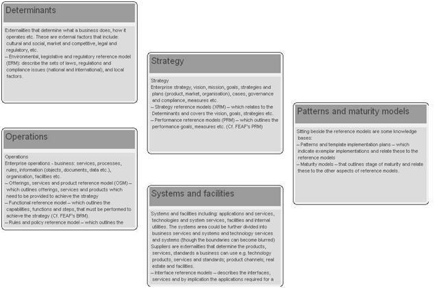
Best practice implementations needs to reflect experience: with cost effective world leading operational national systems; several generations of change i.e. experience with different models of private sector and public sector collaboration; in creating and extending systems of policy, regulation and governance; of the affects of different governance regimes, cultures and from international programmes. They therefore need to cover:

There is no denying of a characteristic that marketing as a concept and priority do not go hand-in-hand with the good departments. Survey of India, National Remote Sensing Centre, Geological Survey of India, Forest Survey of India, National Bureau of Soil Surveys and Land Use Planning (NBSS & LUP) and many other member-organization of NSDI are no exception. As a matter of interest, if you try to know what all is available in India from the portals of NSDI and other organizations, you are hardly rewarded by the desired information…

Metadata is commonly defined as “data about data” and also plays a critical role in any Spatial Data Infrastructure (SDI) initiatives. Metadata not only provides users of spatial data with information about the purpose, quality, actuality and accuracy of spatial datasets, but also performs vital functions that make spatial data interoperable, that is, capable of being shared between systems…

How can we plan and decide upon urban growth?, which house to buy as a secure investment?, which properties are at risk? All these are critical questions we have to face in a changing world and that may affect permanently our lives. For this reason, today it is much more important to make the correct decisions, whether for designing the national economy or making personal plans for the future.
Making decisions requires knowledge,…

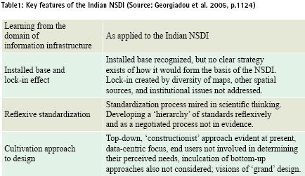
Special characteristic of spatial data is that it can be shared and used for many other purposes than the one, for which, it was originally produced. To facilitate its efficient sharing and reuse, it needs to be properly managed in the form of infrastructure i.e. Spatial Data Infrastructure (NSDI). This is one of the reasons that many countries are developing National Spatial Data Infrastructure (NSDI). But the challenge of developing a successful NSDI depends largely on its implementation which is so significant that none of the two key stakeholder groups i.e. public or private sectors can address it at their own. Therefore, if efforts are made to implement such initiatives by only one of the key stakeholder groups then the result may be partially if not totally failure to get the tangible benefits truly intended from such initiatives. As an example, Indian NSDI is explored in this context.

The European Union’s INfrastructure for Spatial InfoRmation in Europe (INSPIRE) initiative is ‘inspiring’ for two important reasons. First, because Directive 2007/2/EC of the European Parliament and of the Council entitled ‘An infrastructure for spatial information in the European Community (INSPIRE)’ (CEC2007) breaks new ground by establishing the legal framework for the creation of a European level spatial data infrastructure and, as a result, the governments of all 27 European Union national member states must modify existing legislation or introduce new legislation to implement its provisions by May 2009. Second, because of the procedures that have been devised for the creation of implementing rules that are generally acceptable to the European stakeholder community who will have to implement them in practice. With these considerations in mind this paper considers the contents of the INSPIRE Directive and discusses the principles underlying the procedures for the formulation of implementing rules.

THE land-sea interface is one of the most complex areas of management in the world consisting of both the marine and terrestrial environments. The coastal zone is also home to an increasing number of activities, rights and interests. Population along the coastline is continuously increasing, bringing about new pressures on the fragile eco-system of the coastal zone. This has brought with it an increased need to more effectively and efficiently manage this area to meet the economic, environmental and social outcomes of sustainable development.

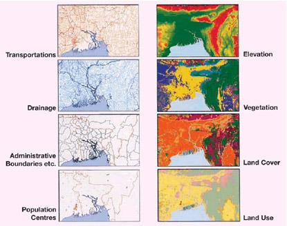
THE United Nations Conference on Environment and in Rio de Janeiro recognized the need to coordinate environmental data and spatial information as an aid to decision making in formulating responses to the challenges of global environmental change and to support sustainable development. The concept of Global Map as a means of doing this was introduced by the Government of Japan and became a formal part of the Agenda 21 action plan. Global Map is a digital map of the world at the scale of 1:1 million which is produced by a cooperative effort of the national mapping organizations of the world. At the time of writing (May 2007) 172 countries and regions were involved in the creation of Global Map. Global Map has eight data layers, four in vector format and four in raster format. These are transportation, boundaries, drainage, population centres (in vector format) and elevation, vegetation, land cover and land use (in raster format).

RECENTLY, in July, 2007, I attended yet another NSDI Workshop – I think the 6th one at that since 2001 when the NSDI was “crafted” in India. This time, in the serene and rainy environs of Goa. Amidst the lush green and beautiful orchard-like estate of the hotel held, was a gathering of a few dedicated and committed NSDIites that I have seen for the past many years – holding on and hoping that the day will come when the NSDI will be operational. The passion for nsdi which was evident clearly and obviously.


 (5.00 out of 5)