| SDI | |
Bridging SDI design gaps
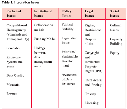
Data Integration IssuesMost spatial applications have interests at a national level datasets, even if they are performed at local level or small regions. With this in mind, a National SDI can provide the institutional, political, and technical basis to ensure the national consistency of content to meet user needs in the context of sustainable development (Willaimson et al., 2003). A National SDI provides the foundation to access built and natural environmental datasets. However, in most countries, these two foundation datasets are normally managed separately to serve different purposes. The lack of uniformity across different jurisdictions within a country often creates problems in attempts to integrate the two datasets at a national level (Tsange, 2005). These issues are caused due to technical heterogeneity, institutional structure, policy issues, legal concerns and social effects of the integration. The most prominent technical issues recognised so far comprise standards, interoperability, semantic, reference system, format, and data quality. The collaboration model (business model) between stakeholders and funding models, and data management approaches are key issues within the institutional arrangement of SDI dealing with integration. On the Policy side, political stability, priorities of nations, legislation and awareness of the users about the existence of data have been found as major issues. The defi nition of RRR (rights, restrictions and responsibilities) surrounding datasets and their use, copyright and intellectual property rights (IPR), data access, privacy, pricing and licensing may differ in jurisdictions and even in different levels of a particular jurisdiction are very challenging. Cultural differences, capacity building, equity and minority, indigenous and women rights are also paramount in the social category, as shown in Table 1. These categories show distinct items, however it must be remembered that they also have effects on each other and especially on SDI components. ConclusionThis paper discussed the importance and requirements of spatial data integration in serving users’ needs and the importance of better understanding multi-source data integration within SDI initiatives. The primary goal is to design a methodological framework to facilitate the integration of built and natural datasets and will advance the knowledge of the National SDI capacity in meeting sustainable development objectives. This will be achieved through the development of new concepts and policies to integrate built and natural environmental datasets. On the other hand, the merit of the data determines the interests and willingness of the users to spend for and use the data sets. One of the key characteristics of the fit-for-use of data is the integratability of the datasets and capability of the datasets to be integrated easily and justifi ably in terms of time and expense. The diversity in data providers creates a great deal of inconsistency in the integration of the datasets, including institutional, technical, social, legal and policy heterogeneity These heterogeneities hinder different aspects and components of a spatial society to facilitate data flow, access and integration. ReferencesFonseca, F., 2005. System Heterogeneieties Analyses of Interoperable Geospatial Information Systems. Hakimpour, F., 2003. Using Ontologies to Resolve Semantic Heterogeneity for Integrating Spatial Database Schemata, Zurich University, Zurich. Rajabifard, A. and Williamson, I., 2004. The Integration of Built and Natural Environmental Datasets in National Spatial Data Infrastructure Initiatives, Eighth United Nations Regional Cartographic Conference for the Americas, Newyork, pp. 7. Taylor, M.J.a.G., 2004. Data Integration Issues for a Farm Decision Suport System. Transactions in GIS, 8(4): 459-477. Tsange, N.A.a.Y.L., 2005. Technical Issues in the Integration of Built and Natural Datasets in National SDI Initiatives, Victorian Pilot Study, Geomatics Department of The University of Melbourne, Melbourne. UNRCC-AP, 1997. Resolution of the 14th UNRCC-AP. In: U. Nations (Editor). Vandenberg, M., 2002. TBL Victoria Scoping Study, TBL Victoria for the Victorian State Government – Department of Premier and Cabinet. Willaimson, I.P., Rajabifard, A. and Feeney, M.-E.F., 2003. Developing Spatial Data Infrastructures: From Concept to Reality. Taylor and francis. Young, A.J.B.a.F.R., 2005. Digital Mapping Data Currency Through Sharing: A Practical Study, SSC2005 Spatial Intelligence, Innovation and Praxis, Melbourne, Australia. |
|||||||||||||||||||||||||||||||||||||||||
|
|||||||||||||||||||||||||||||||||||||||||
|
Pages: 1 2


 (51 votes, average: 1.18 out of 5)


