| SDI | |
Bridging SDI design gaps
|
||||
| With applying modern technologies to generating spatial data, the amount of spatial data is increasing dramatically and huge amounts of data sets are being created and stored by different agencies.
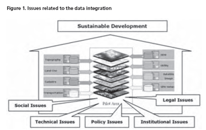
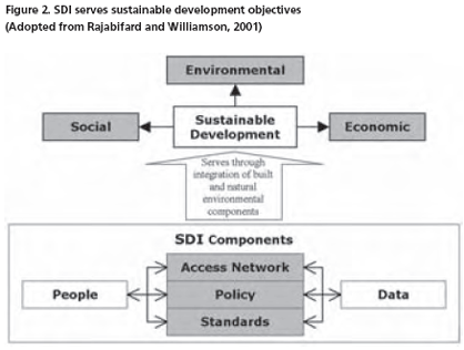
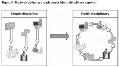
Despite the growth of spatial datasets and the expansion of their use in different applications and new emerging services, they are being acquired and maintained by different organizations under different policies and even by organizations from different political and administrative levels. In such organizational arrangement, the spatial data providers produce and manage their own datasets without considering the reuse and integration of the datasets by other users, so most of the datasets have been produced and managed for a single purpose. In this regard, there is a great deal of reports, stating different aspects of multi-source built and natural datasets integration. They have highlighted the heterogeneity and inconsistency of the initiatives and activities in different dimensions and most of them have attempted to address these impediments by documenting the technical inconsistencies (Fonseca, 2005; Young, 2005; Taylor, 2004; Hakimpour, 2003). Nevertheless, in many cases the technical inconsistency arises from non-technical problems and occurs as result of other marginal issues; belong to social, institutional, legal and political inconsistencies of different custodians and relevant organizations. Over the last decade these needs are being addressed and overcome by establishing spatial data infrastructures (SDI) where one ofits key objectives is to facilitate the integration of multi-source datasets, and specifi cally cadastral (built) and topographic (natural) spatial data (Rajabifard and Williamson, 2004). With this in mind, this paper aims to discuss the key elements of integration in order to better understand and describe the technical, jurisdictional, institutional, legal and land policy perspective surrounding the foundation datasets (cadastral and topographic) in a National SDI initiative. The paper is based on a research which will investigate the justifi cation for integrating these two forms of spatial data in support of sustainable environment and develop a model and framework capable of being used in diverse jurisdictions. Spatial Data IntegrationSpatial services commonly rely on more than one data source and it springs from their multi-criteria nature. As a consequence, integration of datasets is the primary and most common task in most, if not all, of the spatial data services. In this regard the technical integration of spatial data has received more attention; nevertheless, non-technical issues seem to be more problematic. This includes the legal, policy, social, and institutional issues (Figure 1) which cause inconsistency in integration. The approach of the current research is to better understand and describe all aspects of issues surrounding the foundation datasets within National SDI initiatives in order to provide an efficient framework for integration by taking both technical and nontechnical issues into account. The importance of the research on integration of multi-source spatial datasets has been highlighted in numerous publications, declarations and resolutions and in particular UN resolutions. Rajabifard and Williamson (2004) have promulgated the integration of built and natural datasets within National SDI initiatives as a major concern in the success of National SDI. Resolution 15 of the 14th UN Regional Cartographic Conference for Asia-Pacific (UNRCC-AP), calls for issues in the integration of cadastral and topographic datasets to be investigated (UNRCC-AP, 1997). The UN Bogor Declaration (1999) urges the creation of National Spatial Data Infrastructure to ensure integration and highlights the homogeneity of the topographical and cadastral datasets (as two core spatial datasets) to achieve the integration to their maximum potential. These declarations also highlight the need for sharing of integrated data among nations, particularly to address common ecological problems in alignment with sustainability objectives. Data integration to meet sustainable development objectivesA perception is growing among government and businesses that the community is demanding they help build a better society for all. There is increased pressure for organisations to become more sustainable (Vandenberg, 2002). A society which is not geographically aware, or “spatially enabled”, is deprived of the ability to develop comprehensive socioeconomic concepts and plans, and effective implementation (Williamson et al 2005). The quality of decision making and policy development relies greatly on having all the necessary spatial information about the natural and built environments. Meeting sustainable development objectives (social, economical and environmental) is possible through a comprehensive understanding of all aspects of the developing and changing environment and it entails merging all built and natural components of the environment to simulate and control the changes. Good governance of spatial data depends heavily on an enabling platform to manage datasets, facilitate collaborations between data stakeholders (provider, user,value added reseller), and develop the policies, standards and data access facilities through addressing policy, legal, institutional and technical considerations. A Spatial Data Infrastructure aids sustainable development to achieve a better perception of the changing environment and control and manage the impacts of the different environmental elements (Figure 2). This aim is done by understanding the environments and built and natural components, their changes and by controlling these elements through monitoring changes and their impacts. Some major international concerns connected to sustainable development are equal access to resources, land management, environmental protection, water rights, indigenous and minorities land rights, and emergency management which can only be addressed by accessing integrated spatial datasets within any regional content. By investigating the approaches of different jurisdictions, at a national and state level in addressing integration issues, governments will achieve a better understanding of the needs and the benefi ts of integration and will lead the data access and SDI policies towards considering the facilitation of multi-source dataset integration as a priority. Studying different jurisdictions with different characteristics such as size, population, political structure, and spatial data policy will assist in determining “best practice” and gives a framework to evaluate the performance of the systems. Multi-disciplinary approach versus singledisciplinary approachBuilt and natural datasets, originally, have been produced to serve different specific purposes and as a consequence they have been managed under different organizational structures with different policies, divergent technical consideration, and diverse priorities. As a result of that, they have been managed to serve their designated discipline which cause inconsistency and heterogeneity when being used by different disciplines. At the same time, nowadays, multi-disciplinary use and application of spatial datasets forces the datasets to go far beyond serving just a single discipline. To move from data management with a single-discipline interest towards multi-disciplinary approach, a holistic framework for data integration within any SDI is required to facilitate the provision the datasets to multidisciplinary users (Figure 3). |
||||
Pages: 1 2


 (51 votes, average: 1.18 out of 5)


